Chandrayaan-1 (M3)
Full Name: Chandrayaan-1
Phase: Operating
Launch Date: October 22, 2008
Mission Project Home Page: http://moonmineralogymapper.jpl.nasa.gov/
Program(s): Discovery
Mineral Moon
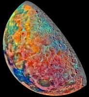
This mosaic of 53 images was recorded by the Jupiter-bound Galileo spacecraft as it passed near our own large natural satellite in 1992. The pictures were recorded through three spectral filters and combined in an exaggerated false-color scheme to explore the composition of the lunar surface as changes in mineral content produce subtle color differences in reflected light. Familiar to Earth dwellers, the lunar near side is on the left, but the space-based view looks down on the Moon's north pole located in the upper half of the image near the shadow line. Blue to orange shades indicate volcanic lava flows. The dark blue Mare Tranquillitatis at the lower left is richer in titanium bearing minerals than the green and orange maria above it. Near the bottom of the image and to the right of Tranquillitatis is the dark oval-shaped Mare Crisium surrounded by shocking pink colors indicating material of the lunar highlands. Credit: Galileo Project, JPL, NASA
When India's space agency launches its first mission to the Moon in 2008, the spacecraft will carry an instrument provided by NASA to map the mineral composition of the lunar surface.
The Moon Mineralogy Mapper (M3) is a state-of-the-art imaging spectrometer which will give scientists their first opportunity to examine lunar mineralogy at high spatial and spectral resolution. It will map the entire lunar surface from an altitude of 100 km at 140 m spatial sampling and 40 nm spectral sampling, with selected targets mapped at 70 m spatial and 10 nm spectral resolution. Targets will include such features as outcrops exposed at the walls and central peaks of large craters, complex volcanic terrain, boundaries where different kinds of rocks converge, unusual or rare compositions, and polar regions.
This information will be important both for scientific and exploration purposes. A detailed characterization of lunar surface mineralogy can dramatically improve our understanding of the Moon's origin and geologic evolution, as well as the early development of the terrestrial planets (the rocky planets Mercury, Venus, Earth, and Mars).
Of course, a detailed map of lunar resources, possibly including water, will be of great practical use to future astronauts who may live and work on the Moon for extended periods of time -- and perhaps to those in the more distant future, for whom the Moon may be a way station en route to other planets.
M3 will be launched aboard India's Chandrayaan-1 (Chandrayaan means "journey to the Moon") spacecraft in March, 2008. The mapping mission will last two years, with active data collection concentrated into four 2-month periods during which lighting conditions will be optimal for this purpose. Global mapping will be given top priority, with the remaining time spent on targeted mapping at M3's highest resolution. Operations, science analysis, and public outreach and education activities will continue through 2010.