Aqua
Full Name: Aqua
Phase: Operating
Launch Date: May 04, 2002
Mission Project Home Page: http://aqua.nasa.gov/
Program(s): Earth Systematic Missions
NASA's commitment to studying the Earth as a global system continues with the Aqua spacecraft (originally called EOS PM-1), representing a key contribution by NASA to the U.S. Global Change Research Program. Aqua carries six state-of-the-art instruments to observe the Earth's oceans, atmosphere, land, ice and snow covers, and vegetation, providing high measurement accuracy, spatial detail, and temporal frequency. This comprehensive approach to data collection enables scientists to study the interactions among the four spheres of the Earth system--the oceans, land, atmosphere, and biosphere.

The National Space Development Agency of Japan's Advanced Microwave Scanning Radiometer - EOS (AMSR-E) is one of six key Earth-observing instruments on board Aqua and has recently been used to obtain images of the sea ice covers of both polar regions, showing their changes from the June 2-4 period to the July 21-22 period. In these images, white indicates the area of sea ice cover and gray indicates land. Because of the time period covered (late spring to summer in the Northern Hemisphere; late fall to winter in the Southern Hemisphere), the area of the ice cover in the Arctic region is decreasing while the area of ice cover in the Antarctic region is increasing, a fact captured very well in these images.
Aqua, Latin for "water," is named for the large amount of information that the Aqua spacecraft will collect about the Earth's water cycle. In particular, the Aqua data will include information on water vapor and clouds in the atmosphere, precipitation from the atmosphere, soil wetness on the land, glacial ice on the land, sea ice in the oceans, snow cover on both land and sea ice, and surface waters throughout the world's oceans, bays, and lakes. Such information will help scientists improve the quantification of the global water cycle and examine such issues as whether or not the cycling of water might be accelerating.
In addition to information about the water cycle, Aqua will also provide information on many additional elements of the Earth system. For instance, Aqua will enable studies of the fluxes of radiation from the Sun and from the Earth that combine to constitute the Earth's radiation balance. It will also enable studies of small particles in the atmosphere termed "aerosols" and such trace gases in the atmosphere as ozone, carbon monoxide, carbon dioxide and methane. The trace gases each have a potential contribution to global warming, whereas the aerosols are more likely to have a cooling effect. See a movie showing global CO2 concentrations at 5 miles above the Earth's surface.
Aqua will also provide observations on vegetation cover on the land, phytoplankton and dissolved organic matter in the oceans, and the temperatures of the air, land, and water. All of these measurements will have the potential to contribute to improved understanding of the changes occurring in the global climate and the role of the interactions among the various elements of the climate system.
One of the most exciting of the potential practical benefits likely to derive from the Aqua data is improved weather forecasting. Aqua will carry a sophisticated sounding system that will allow determination of atmospheric temperatures around the world to an accuracy of 1° Celsius in 1-km-thick layers throughout the troposphere, the lowest portion of the atmosphere. The troposphere extends to an altitude of about 10–15 km, depending on location, and contains most of the global cloud cover. The anticipated 1° Celsius accuracy far exceeds current accuracies from satellite observations and, in conjunction with the moisture profiles also obtainable from the Aqua sounding system, will offer the potential of improved weather forecasting. NASA is working with the U.S. National Oceanic and Atmospheric Administration and the European Centre for Medium-Range Weather Forecasts to facilitate the incorporation of the Aqua data in their weather forecasting efforts.
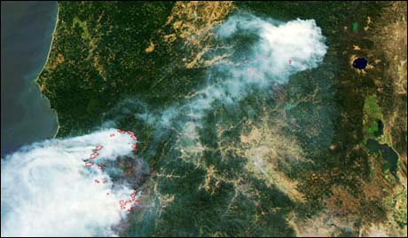
AQUA image of the 2002 Biscuit Fire in the Klamath Mountains, Oregon. Aqua increases the likelihood of getting cloud-free images of fire activity, which helps scientists better predict the rate and direction in which fires will spread. It also helps them anticipate how fires will affect the air quality of cities and towns that are downwind.
Aqua is one of a series of space based platforms that are central to NASA Earth Science, a long-term study of the scope, dynamics and implications of global change. Aqua is a joint project of the United States, Japan, and Brazil. The Aqua program is composed of Aqua and other spacecraft (including Terra and Aura) and a data distribution system (ESDIS, and Mission Operations Center Implementation Team). Multidisciplinary teams of scientists and researchers from North and South America, Asia, Australia and Europe will put this data to work.