|
|
|
 |
|
NRCS Home
|
|
|
CEAP National Assessment: Grazing LandsThe Grazing Lands component of the CEAP National Assessment (CEAP-Grazing Lands) will quantify the environmental effects of conservation practices used on pastureland and rangeland. 
What is Grazing Land?“Grazing land” is a collective term used by the USDA-Natural Resources Conservation Service (NRCS) for rangeland, pastureland, grazed forestland, native and naturalized pasture, hayland, and grazed cropland. Although grazing is generally a predominant use on grazing lands, the term is also applied independently of any actual use for grazing. Grazing land is also described as land used primarily for production of forage plants maintained or manipulated primarily through grazing management. It includes all lands having plants harvestable by grazing without reference to land tenure, other land uses, management, or treatment practices. (USDA NRCS National Range and Pasture Handbook 2006). There are 588 million acres of grazing lands in the U.S. (USDA-NRCS National Resources Inventory). The ecology and use of rangelands in the West are intertwined for non-federal and federal lands when it comes to wildlife habitat, grazing operations, water quality, and water quantity issues. Management at many levels transcends ownership boundaries. These documents require Acrobat Reader.
CEAP Grazing Lands Assessment Fact Sheet (PDF; 1.5 MB) High resolution version of the grazing lands dot map (PDF; 10.5 MB) 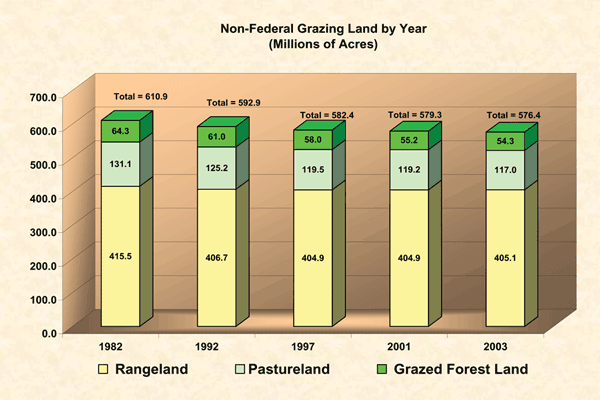
ApproachIn 2004, a group of rangeland and pastureland scientists and conservation experts provided early advice to the CEAP-Grazing Lands effort. Their guidance included the overall objectives, data availability, USDA-Agriculture Research Service (ARS) research, and a possible analytical framework. Based on the input of these experts, CEAP-Grazing Lands will comprise several complementary facets to quantify environmental effects. CEAP-Grazing Lands will begin with a comprehensive literature review of what is currently known about the effects of the dominant conservation practices on pastureland and rangeland. It will be informed by watershed studies which contain rangeland, pastureland, grazeable forest, and cropland. This national assessment will also use data collected for the National Resources Inventory (NRI) Rangeland Field Study to populate the WEPP/SPUR (Water Erosion Prediction Project/Simulation, Production, and Utilization of Rangeland) model. Because of the very diverse ecosystems represented by grazing lands, a broad regional approach will be considered to set up sideboards for future studies. Projects
BibliographyEnvironmental Effects of Conservation Practices on Grazing Lands, September 2006. LinksCEAP-Grazing lands will involve cooperation and coordination with multiple entities. This document requires Acrobat Reader. The American Forage and Grassland Council will be consulted on pastureland effects in the central and eastern states. The Rangelands West web site is a valuable portal into the wealth of information available on rangelands through lands grant universities and others. The Society for Range Management will be involved in the literature synthesis of the effects of conservation practices on grazing lands. State of the Nation's Ecosystems by The Heinz Center is an important effort to develop indicators for ecological values of what they call grasslands and shrublands. The Sustainable Rangeland Roundtable focuses on identification of social, ecological, and economic indicators of rangeland sustainability. USDA Agricultural Research Service National Program: Rangeland, Pasture, and Forages USDA Agricultural Research Service National Program: Water Resource Management Contact |
|
|
|