RFK Stadium Site Redevelopment Study
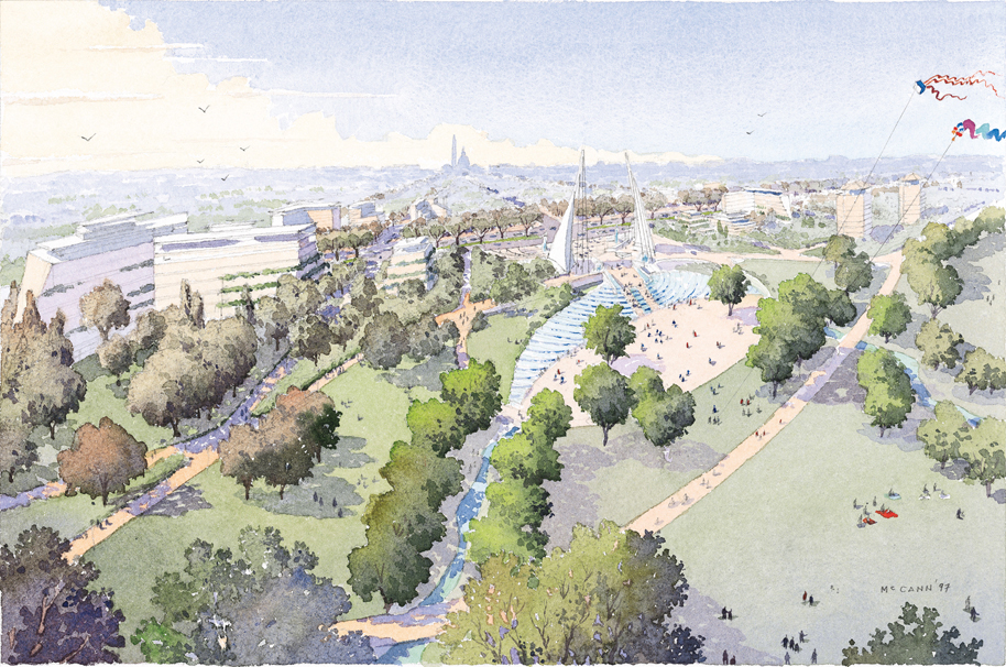
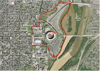
RFK Stadium, built by the federal government in 1961, sits on 190 acres of federal land on East Capitol Street along the banks of the Anacostia River. The federal government leases the site to the District of Columbia for use as a stadium. However, with the Washington Nationals baseball team opening its 2008 season in a brand new stadium on South Capitol Street, and D.C. United seeking a new soccer venue, the stadium may soon be empty. Anticipating this eventuality in 2006, NCPC studied potential uses for the site, which is depicted as a grand gateway to the city in NCPC's 1997 Legacy plan. As the RFK study progressed, NCPC planners shared their vision for the site in three public meetings that helped shape the study. Released in December 2006, the RFK Stadium Site: Redevelopment Study, envisions the site as a lively destination for visitors and residents and offers specific recommendations for the site's future. NCPC recommends that the interior of the site include residential and mixed-use development. A new commemorative site across from the D.C. Armory, which is adjacent to the stadium, would encompass a 15-acre superblock surrounded by a well-designed landscape. The revitalized area also would feature restaurants and cafes as well as services such as dry cleaners and bookstores.
With proper planning, the site could feature a large waterfront park, recreational fields, and open space. Commemorative works would enhance the site, which could be connected to surrounding neighborhoods by pedestrian and bicycle paths. Among other recommendations, the study calls for upgrading the street network to make Constitution, Independence, and East Capitol the main axial streets. Currently, Independence Avenue and C Street, NE, act as the main roadways feeding into RFK Stadium. The RFK Stadium site is an important part of the District’s Anacostia Waterfront Initiative, which is aimed at transforming the Anacostia River into a viable waterfront. NCPC planners would like to improve environmental conditions at the site and in the river, which currently receives a substantial amount of untreated run-off from the stadium's paved surfaces. NCPC produced its plan with input from numerous stakeholders including the U.S. Commission of Fine Arts, the District’s Office of Planning and Department of Transportation, National Park Service, Washington Metropolitan Transit Authority, and the general public. In addition to a public meeting on October 19, 2006, NCPC hosted a public comment session in July 2006, and staff presented the draft RFK Stadium Site Redevelopment Study at a public Commission meeting on October 5, 2006. |
401 9th Street, NW
North Lobby, Suite 500
Washington D.C. 20004
Phone: (202) 482-7200
Fax: (202) 482-7272
Email: info@ncpc.gov
North Lobby, Suite 500
Washington D.C. 20004
Phone: (202) 482-7200
Fax: (202) 482-7272
Email: info@ncpc.gov