| |

Madison Wetland Management District
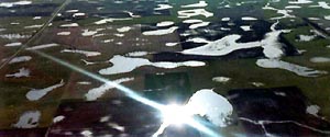
The Madison Wetland Management District (WMD) was established to preserve wetlands and manage habitat for waterfowl and other wildlife. Headquartered in Madison, South Dakota, the District staff manages 38,500 acres of upland and wetland areas, called waterfowl production areas (WPA). The wetlands found on WPAs also help prevent flooding in rainy years by storing the water while it slowly percolates into the ground. The northeast portion of the District (Deuel County) lies within the "Coteau des Prairie" or tall grass prairie region of South Dakota.
The District staff also administer two easement programs with private landowners. One is a wetland easement program consisting of 52,200 acres of wetlands that are protected from drainage. The second is a grassland easement program that protects 39,000 acres of grasslands from plowing.
Lands are acquired, in part, by the U.S. Fish and Wildlife Service (Service) with funds from the sale of Federal Duck Stamps.
Getting There . . .
The District headquarters is located 2 miles east of the town of Madison, South Dakota, and 3/4 miles south of the junction of Highway 34 and Highway 19.
Get Google map and directions to this refuge/WMD from a specified address: |
|
|
|

Environmental Education
Fishing
Hunting
Interpretation
Photography
Wildlife Observation
Learn
More >>


WPAs are actively managed to improve habitat for nesting and migrating waterfowl and for wildlife in general. Wetlands may be restored, or they may be created by plugging a ditch or constructing a low dam.
Uplands, previously farmed, are planted to native grass stands. All remaining tracts of native prairie are protected and made more attractive to nesting birds using periodic haying, grazing, and prescribed burning. These management tools mimic the historic patterns of wildfires and large herds of grazing bison and other ungulates. Invasive weeds are controlled through chemical, mechanical, and biological means. Local farmers assist the District in carrying out management activities through cooperative agreements.
|
|