Surface Temperature Field Campaign - Day 3
28 November 2007
More schools have entered data onto the GLOBE Web site for the surface temperature field campaign. It is great to see the participation from all over the world:
| Roswell Kent Middle School, Akron, Ohio, USA Chartiers-Houston Jr./Sr. High School, Houston, PA Kilingi-Nomme Gymnasium, Parnumaa, Estonia Polaris Career Center, Middleburg Heights, Ohio, USA White Cloud Public, White Cloud, Michigan, USA Ingomar Middle School, Pittsburgh, Pennsylvania, USA Lorain Community College Early College High School, Elyria, Ohio, USA Kilingi-Nomme Gymnasium, Parnumaa, Estonia White Cloud Public, White Cloud, Michigan, USA Blue Valley High School, Stilwell, Kansas, USA Roxboro Middle School, Cleveland Heights, Ohio, USA Bowling Green State University, Bowling Green, Ohio, USA Ida Elementary School, Ida, Michigan, USA Whitehall High School, Whitehall, Michigan, USA Birchwood School, Cleveland, Ohio, USA Gimnazium in Toszek, Toszek, Poland Waynesboro Senior High School, Waynesboro, Pennsylvania, USA |
The only snow observations that have been recorded along with the surface temperature observations have come from White Cloud School in White Cloud, Michigan. I think that will change over the next few days. The middle of Michigan was getting snow this evening and is expected to get more lake effect snow tomorrow. (See map below to locate states).
I really enjoy reading the comments that you are leaving on your observations. Lorain County Community College Early College High School in Elyria, Ohio is measuring the surface temperature on leaves and is measuring the depth of the leaves. That’s very innovative.
Today, I wanted to look at snow coverage in the Northern Hemisphere. Can you tell that I am obsessed with snow? As you can see in the image below of snow and ice coverage in the Northern Hemisphere for today, 28 November 2007 (Figure 3), much of Russia and Canada were covered with snow and parts of Europe and the United States are starting to get covered in snow. And, ice is forming in the Arctic Ocean (yellow is ice).
In winter, large areas of northern Asia and northern North America get covered with snow. Cold high pressure systems called Arctic Highs, form over these large, uniform areas and the air takes on the characteristics of the surface. In this case it will be cold and dry. The skies become clear and the winds calm which leads to the very cold temperatures that are often associated with these locations. As the snow pack grows along its southern border, the cold air masses can get large enough to move from the Arctic south into the United States in North America and south into Mongolia and China in Asia. What happens once the air mass gets south of the snow? The air mass is warmed by the ground surface. The air is still cold – but not as cold as before. If you go to the main Web site from NOAA, you can see a time series of snow cover in the world. You can see how the snow is laid down and when. Quite a bit of snow cover is now present in Canada. That means that cold air masses can come through Canada down into the United States without being modified, i.e. without having their air temperature or humidity changed.
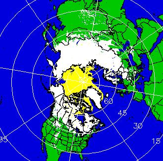
Figure 1. Snow depth for 28 November, 2007 from the NOAA Satellite and Information Service Web page.
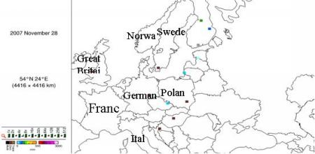
Figure 2. Map created on the GLOBE Web site showing student snow depth observations for 27 November 2007. Do the student GLOBE data match the satellite derived snow cover? If not, why do you think it does not match.
You can see in the GLOBE student data map that on 27 November 2007, there is snow in Czech Republic, Latvia.
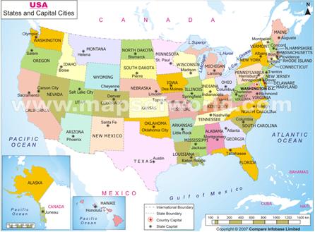
Figure 3. Map of the USA, to locate the states mentioned in the blog.
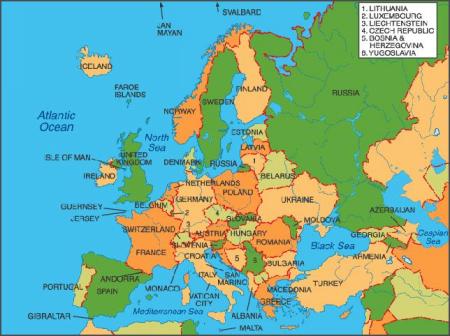
Figure 4. Map of Europe to locate countries mentioned in the blog.
Dr. C