Archive for February, 2007

Local Climate Part 4. Human Metabolism — What is that?

Friday, February 23rd, 2007

Human metabolism isn’t the largest term in Figure 4 in the last blog, but you probably don’t think that you are a source of warming! David Sailor, of the Portland State University in Oregon, uses the number of calories we eat to estimate how much heat we give out. Basically, when we eat, we are stoking our furnaces!

If you have been to a large event in an indoor auditorium, you have experienced the effects of “human metabolism.” Especially if you, like me, like to get there early to get a good seat.

I first really noticed this at a school event at Whittier Elementary, where my children went to school. The auditorium, when we arrived, was cold. We didn’t take our jackets off at first. But as people started coming in, it got warmer and warmer. By the time the program started, everyone was quite warm, and all our jackets were off.

We can follow Sailor’s reasoning to estimate how much people are heating the auditorium. Suppose each person releases on the average 100 kilocalories an hour (the “calories” people refer to when referring to “watching their calories” are really kilocalories), and there are 300 people in the auditorium. The volume of the auditorium is 30 m x 20 m x 10 m, or 6,000 cubic meters. I assume the air density is 1 kilogram per cubic meter.

We need a conversion factor to translate “heating” into temperature change – that conversion factor is called the “specific heat”, which for air, is about 1000 in metric units.

I need to convert the kilocalories to Watts (Joules per Second) by multiplying by 4186 (Joules/Kilocalorie) and dividing by 3600 (seconds per hour) – to get about 116 Watts.

So

Total Heating = 300 people x 116 Watts per person = 34,800 Watts

Total amount (mass) of air being heated:

= 6,000 cubic meters x 1 kg /(cubic meter)

= 6000 kilograms

Temperature change per second = Total Heating divided by (Specific Heat x Mass)

= 34,800 divided by (6000 x 1000)

= 0.006 Celsius each second.

Meaning the 300 people raise the temperature by 0.006 degrees each second! So in a minute, 300 people heat the auditorium by about a third of a degree Celsius.

This calculation is only approximate, of course. I’m not sure how many calories children give off. People will open the doors to the auditorium to cool things off. And – if it gets too hot, people will start getting warmer themselves.

Can you think of other examples of human heat? You notice how you can warm your hands by blowing on them on a cold day? And why do you think you feel so toasty warm when you are under the covers (or in a sleeping bag) on a cold night?

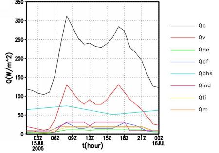
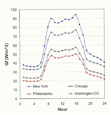
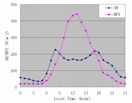
Acknowledgments. Thanks to Shiguang Miao for his help with the Beijing Figures, Joseph Zehnder with supplying me with material on Phoenix, Bob Harriss with supplying me with NASA web sites for images of cities, Fei Chen for informative discussions, and David Sailor for Figure 5 and other useful information.

More about how people heat up cities

Friday, February 16th, 2007

This is the third installment of a series on local climate.

To understand how people’s activities heat up a city, scientists use information on traffic, the energy used by homes, factories, and businesses, and where people live.

For example, Figure 4 shows the how the anthropogenic heat source is divided up during the day. This plot is for the 500 x 500 m area for which the anthropogenic heat source is largest in Beijing. This spot in Beijing has traffic-related peaks in the morning and evening, related to people riding or driving to and from work. So do Phoenix and Houston, and other cities with morning and evening rush hours. If you compare Figure 3 and 4, you will see that the anthropogenic heat source is bigger in winter. Can you guess why? Probably some of the difference is related to “domestic heating”, and some of the difference is because Figure 4 is for the place in Beijing with the largest anthropogenic heat source.

Estimated anthropogenic heat source for part of Beijing

Figure 4. Estimated in anthropogenic heat source for the part of Beijing with the largest values. Qa = total, Qv = vehicle heating (based on traffic), Qde = from domestic electricity, Qdf = from domestic fuel consumption, Qdhs = from district heating system, Qind and Qti = from industry, Qm = from human metabolism. (Courtesy Shiguang Miao)

How do cities compare? Figure 5 shows the estimated daily pattern of the anthropogenic heat source from four U.S. cities during January based on citywide human energy-use patterns. It is important to note that this figure represents the city-wide average heating rather than the local peak in the downtown areas (as illustrated in Figures 3 and 4 for Beijing). In New York City, the city-wide average reaches almost 100 Watts per square meter. Can you guess why the four cities differ? (Remember that the previous figures are only from a part of Beijing, so we can’t compare Beijing to New York with the information we have here.)

January human-generated heat for four U.S. cities
Figure 5. January human-generated heat for the four U.S. cities with the largest values. Figure courtesy of Prof. David Sailor, Portland State University.

Why Cities are Warmer than the Countryside

Wednesday, February 7th, 2007

(This continues from the previous posting, which compares surface temperatures at two cities to the surrounding areas.)

2. Why are cities warmer than their surroundings?

First, cities have much more concrete,asphalt and other man-made materials. When sunlight hits these surfaces, they absorb energy, heat up and warm the air above them. In contrast, some of the sunlight hitting a field of grass or crops is used to evaporate water from the soil and to draw water from the plants. Thus sidewalks can be too hot to walk barefoot on in the summertime (unless they are wet!) while it’s easy to walk barefoot on the grass.

Second, while buildings provide some shade during the day, they also trap infrared (”heat”) radiation at night. Have you ever used an infrared thermometer? (See GLOBE surface temperature protocol.) Try pointing an infrared thermometer at the side of a building. If you don’t have one, just feel the sides of buildings as you walk by. You will see that the buildings stay warm at night. Buildings radiate heat in all directions – including to buildings across the street, which radiate heat back to them. So the walls of buildings in a city are warmed by surrounding buildings.

You can observe the effect of warming of surfaces by buildings on a frosty night. If you have a car parked in the open but near a building, you will see that the windows facing the building have less frost (or no frost), while the windows on the opposite side have more frost, and the windshield, facing partially upward, probably has the most frost.

Third (and I think this one is the most fun), people are the sources of heat (so-called “anthropogenic heating”. When we use energy, we heat up the environment. For example:

  • Heating and air conditioning of our homes release heat to the outside air
  • When we use electricity we produce heat
  • Burning fuel in cars and trucks releases heat
  • Factories and oil refineries release heat
  • Businesses release heat
  • Our bodies produce heat

Think about the warm smoke coming out of power-plant chimneys, and cooling towers for nuclear power plants. Put your hand on your television or over an incandescent light bulb – it’s warm. Have you ever felt the air coming out of the tailpipe of a car? It’s hot. Once a car operates for awhile, its tailpipe becomes too hot to touch.

How important is anthropogenic heating (or heating due to people’s activities) compared to the effects of concrete and other urban ground cover?

Figure 3 compares the heat supplied to the air by the human activities listed above, for an urban part of Beijing to the heat supplied by the warm surface (concrete, asphalt, buildings, etc.). At noon, the anthropogenic heating in this part of Beijing almost half that due to the surface heating in this part of Beijing. Averaged over the whole day, the anthropogenic heating is over half that due to surface heating. The effect of both types of heating is probably less in other parts of Beijing.

The units are Watts per square meter. This is the same unit used for incandescent light bulbs. If you have an incandescent light bulb (this kind gets warm) nearby, look at the bulb and see how many Watts it radiates.

The “heating” in Figure 3 is “sensible heat” (we can feel it) carried by air currents (convection). The sensible heat transport above a field of green grass at noon in the summertime is of the order of 100 Watts per square meter. The heat transport above a field of harvested crop might be more like 300 Watts per square meter, and the amount of solar energy hitting Earth’s surface on a fair-weather summer day reaches slightly over 1000 Watts per square meter at noon on a clear day. For parts of Tokyo and Houston, the human-generated heat source reaches 1000 Watts per square meter.

Accounting for anthropogenic heat sources and trapping of heat by buildings improved forecasts of minimum temperatures in Phoenix and Philadelphia. In both cases, these effects led to warmer temperatures at night.

Infrared image of surface temperatures for Salt Lake City, Utah
Figure 3: For an urban part of Beijing, summer sensible heat flux (HFX) from the city surface, and the anthropogenic heat source (AH) from human activities. Figure courtesy of Shiguang Miao.Next time — more about how people heat up cities.

Climate — from your back yard to the globe. Local Climate

Friday, February 2nd, 2007

In the next few months, I will be writing about climate and climate change. My purpose is to discuss the various ways we influence climate both locally and globally. The plan is to start locally, with the effect of cities on climate. I will follow with a discussion of our effects on regional climate, and then close with a look at the global climate. This sequence will probably be interrupted by other topics if they come up.

1. Local climate

Local climate is probably the easiest for us to understand because we can see it in our daily lives. It has been known for decades that cities affect climate. Before air conditioning, the cities would get so hot in the summertime that people who had the money would leave the cities during the weekends for cooler weather in the countryside.

The figures show two examples. In Figure 1, an infrared image of Salt Lake City, notice how the urban area (yellow and red) is warmer than the suburbs (mixed greens and blues) which are warmer than the surrounding mountains. I’m not sure why some of the mountains (upper right) look warm – perhaps there are rocks there. Figure 2 is a satellite image from MODIS (MODerate Resolution Imaging Spectroradiometer) showing the surface temperatures in Beijing in the afternoon. The MODIS pixels are much larger, so the picture looks blurrier, but the message is the same: Bejing is also warmer than the surrounding area.

Infrared image of surface temperatures for Salt Lake City, Utah
Figure 1. High-resolution Infrared image of surface temperatures for Salt Lake City, Utah. The Wasatch Mountains are on the eastern side. NASA/Marshall Space Flight Center, from Science@NASA website. Quick look data form the Urban Heat Island Pilot Project, 1998. White areas are approximately 71C; Dark areas are 39-26 C.
MODIS land surface temperature for Beijing and surrounding area
Figure 2. MODIS land surface temperature for Beijing and surrounding area. Local time 12:45. The scale on the right is surface temperature in degrees Celsius. White is missing data or water bodies.