|
|

|
|
|
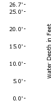
| 25.7 |
Water over Sam Usry Rd 1 mi east of US15. |
| 24.1 |
Flood of record - Sept. 6, 1996 - Hurricane Fran. |
| 20.7 |
Major Flooding - Water over railroad tracks 0.25 mi east of railroad bridge over Tar River. |
| 18.7 |
Moderate Flooding - Water over Tom Hunt Rd 1 mi west of NC96. |
| 17.7 |
Water over Tar river Rd 1.5 mi south of US15 at Aycock Creek. |
| 15.7 |
Flood Stage - Minor Flooding - Water approaches Tar River Rd and Hunt Rd. |
| 2.7 |
Bankfull |
|
|
|
|
Hydrologic Resources
|
Additional Resources
|
|
|
| |
|
|
|
|
The National Weather Service prepares its forecasts and other services in collaboration with agencies like the US Geological Survey, US Bureau of Reclamation, US Army Corps of Engineers, Natural Resource Conservation Service, National Park Service, ALERT Users Group, Bureau of Indian Affairs, and many state and local emergency managers across the country. For details, please click here. |
 |
NWS Information |
 |
|
|
|
|
|