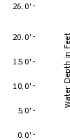
Advanced Hydrologic Prediction Service: Newport/Morehead City: Tar River at Greenville
Skip Navigation Linkweather.gov 
NOAA logo - Click to go to the NOAA homepage National Weather Service   NWS logo - Click to go to the NWS homepage
Advanced Hydrologic Prediction Service

Tar River at Greenville, NC (PGVN7)

Data Type


Inundation Levels
NAVD88 Stage

26.026.0
25.025.0
24.024.0
23.023.0
22.022.0
21.021.0
20.020.0
19.019.0

Major Flooding Begins

18.018.0
17.017.0

Moderate Flooding Begins

16.016.0
15.015.0
14.014.0
13.013.0

Flooding Begins

12.012.0
11.011.0
10.010.0
9.09.0
8.08.0
7.07.0
6.06.0


  Map Zoom In Map Zoom In Map Zoom In Map Zoom In Map Zoom In Map Zoom In Map Zoom In Map Zoom In Map Zoom In
Weather Forecast Office Newport/Morehead City, NC Southeast River Forecast Center

To see all current watches and warnings, click here.
Scale Map

Hydrograph River at a Glance Download Inundation
Mapping
Weekly Chance of
Exceeding Levels
Chance of Exceeding Levels
During Entire Period
Image Type:
Current Stage: 4.44 ft at 20:00 UTC 01/15
Map Zoom In Map Zoom In Map Zoom In Map Zoom In Map Zoom In Map Zoom In Map Zoom In Map Zoom In Map Zoom In
Please wait while the page loads.
  

Selected Inundation
NAVD88: N/A ft
Stage: N/A ft

Print / Save Image
About Inundation
Download Dataset(s)
FAQ
User Guide
Inundation Sites
Mouse Location*
Latitude: N/A N
Longitude: N/A W
* All mouse location values are estimates only.

Zoom InClick on the image to zoom in

Graphical representation of flood inundation for NWS flood categories are based on steady state hydraulic modeling of water surface elevations for incremented discharges. Map shows approximate inundation areas for given water surface elevations and should not be used for navigation or permitting or other legal purposes, but strictly as a planning reference tool.

North Arrow Flood Categories (in feet)
Major Flood Stage:19
Moderate Flood Stage:17
Flood Stage:13
Action Stage:12
Below Flood Stage:

USGS Gauge Location USGS Gauge Location

Extent of Inundation Study Boundaries Extent of Inundation Study Boundaries

Historical Crests
(1) 29.74 ft on 09/21/1999
(2) 24.50 ft on 07/28/1919
(3) 22.20 ft on 08/22/1940
(4) 19.70 ft on 03/14/1958
(5) 18.20 ft on 09/17/1996
Show More Historical Crests

Return to Area Map

Impacts & Photos Collapse
30.0 
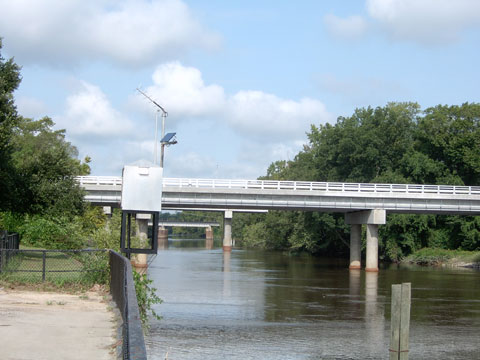
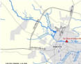
Numerous homes adjacent to the river in the city of Greenville will flood. All roads in and around Greenville become flooded and are impassable. Numerous homes and roads adjacent to the river will flood countywide.
24.0 Devastating flooding for all areas adjacent to the river and tributaries. Water will begin to flood the Pitt-Greenville Airport. Water will overflow into the city of Greenville. Nearly all major roads countywide will become flooded and impassable.
22.0 Water will overflow into the city of Greenville. Several secondary roads will also flood. Some homes along the river will flood. Evacuations will be needed. Water will begin to flood the Tar River Estates and Beech Street Villas next to the river. On the north side of the river...water will flood up to the intersection of Mumford Road and Highway 33. Numerous tributaries will flood roads and homes countywide.
20.0 Water will flood several homes near the river. Water will begin to flood Town Commons and adjacent areas in the city of Greenville. Many acres of farmland flooded.
19.0 Secondary roads adjacent to the river will flood. Water will begin to reach a few homes near the river. Many acres of farmland flooded.
18.0 Much of River Park North Flooded. River Drive, including Dockside Duplexes, in Greenville begins to flood. Seine Beach Road in Grimesland flooded.
17.0 Water will begin to flood some secondary roads near the river. Flooding will continue for low lands adjacent to the river. Residents who live in flood prone areas near the river should begin to move property to higher ground.
16.0 Widespread low land flooding adjacent to the river. Some farmland will begin to flood across Pitt county.
15.0 Low land flooding adjacent to the river can be expected.
14.0 Minor low land flooding adjacent to the river can be expected.
13.0 Minor flooding of low lying areas adjacent to the river can be expected.
Photos
(1) Gauge Site

Other Data Sources:
Corps of Engineers (COE) Info for Greenville
U.S. Geological Survey (USGS) Data and Site Info for Greenville

Additional Information Collapse

Gage Photos
Gage Photo
Inundation Map
Inundation Mapping


Resources Collapse
Hydrologic Resources
Additional Resources
   

Collaborative Agencies Collapse
The National Weather Service prepares its forecasts and other services in collaboration with agencies like the US Geological Survey, US Bureau of Reclamation, US Army Corps of Engineers, Natural Resource Conservation Service, National Park Service, ALERT Users Group, Bureau of Indian Affairs, and many state and local emergency managers across the country. For details, please click here.

NWS Information
National Weather Service
Newport/Morehead City Weather Forecast Office
533 Roberts Rd
Newport, NC 28570
(252) 223-5122
Ask Questions/Webmaster
Page last modified: 12-Jun-2008 4:20 PM
Disclaimer
Credits
Glossary
Privacy Policy
About Us
Career Opportunities