|
|
|
|
Hot Springs National Park
Sunset Trail
|
|
|
|
|
|
 |
 |
| NPS photo | |
 |
The Sunset Trail is the longest trail in Hot Springs National Park, covering more than 17 miles. Crossing all types of terrain, the trail passes by the highest elevation in the park as well as Ricks Pond and also makes its way through the most remote areas of the park. You can expect to find quite a variety of wildlife in these less frequented pockets, which serve as refuges for such seldom seen local species as wild turkey and white-tailed deer, most common in the fall months. Wildflowers are plentiful along the trails in late spring, summer, and fall.
Due to the length of the trail, visitors usually break the hike up into three separate sections. The first section traverses West Mountain and is probably the most popular. It is also the most recommended stretch due to its proximity to parking and the downtown area. It has several overlooks of the southern part of Hot Springs and Lake Hamilton. The second section is the most scenic, crossing through a beautiful mixed pine and hardwood forest on Sugarloaf Mountain and revealing views of such novaculite outcroppings as Balanced Rock. Old roadbeds make up portions of this section of Sunset Trail. The third section passes through land on Stonebridge Road that was once part of the Fordyce family estate. Purchased by the family years ago, the land is part of the crucial recharge area for the thermal springs. The trail crosses Fordyce Mountain. The waterworks for the city of Hot Springs are below the trail on the north side of the ridge.
There are two spurs that branch off the Sunset Trail: Balanced Rock Trail and Fordyce Peaks Trail.
Choose another trail.
|
 |
| Sunset Trail trailhead at West Mountain Summit |
 |
First Section of Sunset Trail: West Mountain (2.9 miles)
This part of the trail offers an overlook of West Mountain. It has ample parking and is close to the downtown area and the National Park Service visitor center. The trail leads to Blacksnake Road, just under 3 miles away. The trailhead is clearly marked at the summit with a map that includes distance and trail information. Two wooden benches provide a place to rest on the return trip. The trail begins as a smooth, gravel path turning into a narrow, rock-strewn trace just after crossing the Mountain Top Trail (approximately 100 yards past the trailhead). You’ll come to a concrete bench, beyond it, the Sunset Trail starts to climb West Mountain and narrows, passing the remains of an old trail shelter to the right. It was the only shelter ever built on this trail.
After a few hundred yards the trail passes an old concrete foundation on the left. Continue walking west on the trail until it crosses a clearing with a power line. Privately owned communication towers exist just ahead on West Mountain. The trail forks just below these towers. The path to the right is the “low” road, and the trail to the left is the “high” road. Take the right trail for ease and a pleasant natural setting. It can be confusing to find your way back to the Sunset Trail if you stray left. Stay on the trail and you will begin to descend at a old, wooden NPS sign. Continue down the trail and wind around towards Black Snake Toad.
The highest elevation in the park (1405 feet or 428 miles) is at the westernmost point of the Sunset Trail, on Music Mountain. The peak can be reached via an overgrown roadbed to your right, although there is not much of a view since the top has not been cleared. Another old NPS sigh with trail distances is here. Do not go left. It is a dead end trail leading out of the park boundaries. As the trail continues, it begins to descend, and the trees take on an eerie, gnarled appearance. Several hundred feet down, the twisting trail leads to a clearing and a view of the towers that were passed earlier. You will pass a metal shed to the left of the trail. The West Mountain section of the Sunset Trail ends at a parking area on Blacksnake Road.
|
 |
| Balanced Rock |
 |
Second Section of the Sunset Trail: Sugarloaf Mountain (2.8 mi.)
Like the first section, this part of the trail has parking at either end. Start by parking at the high point on Blacksnake Road and crossing the road to the trailhead. A private residence lies to the east; please be courteous and respect the privacy of the landowner. The trailhead sign gives the distance to the Balanced Rock Trail (1.4 miles).
The first 50 yards of the trail are smooth but steep as the descent down one side of Sugarloaf Mountain begins. Watch for wildflowers such as fire pinks and phlox in early spring. An old roadbed comes up to meet the trail from the lower left. Stay on the trail and keep an eye out for old trees serving as dens for forest animals such as raccoons and squirrels. Parts of this section pass through land once owned by Henry Massie Rector, the first Confederate Governor of Arkansas during the Civil War. After regaining the ridge, a sharp bend in the trail would appear to lead right, but stay on the left trail near a small pile of rocks. While hiking along this ridge notice how ferns and lichens live in and around novaculite rocks. The trail narrows here and is very rough.
A steep section of trail begins several hundred yards away, passing a deep ravine on the left just before crossing an old road. Stay on the trail, and a fantastic view of the Hot Springs Rehabilitation Center and the Mountain Tower will appear to the right. A power line crosses the trail three times before you reach the Balanced Rock Trail sign. From there it is but a 0.2-mile stroll to one of the most scenic vistas in the park.
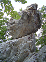
The last part of the trail leads to the Balanced Rock, which is a novaculite outcropping sitting precariously upon another novaculite boulder. After returning to the main trail, a sign states that the Cedar Glades trailhead is 1.2 miles northeast of here. This last part of the trail is a pleasant walk; however, it includes a short, steep, rocky section as it approaches Cedar Glades Road. Again, be careful. You’ll find room to park and an informative trailhead sign on Cedar Glades Road.
|
 |
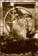
| Deborah Warren, 2006 Artist-In-Residence | | Water wheel used to generate electricity for Fordyce estate. |
 |
Third Section of Sunset Trail: Stonebridge Road (4.0 mi.)
The same gravel parking area on Cedar Glades road that serves the second leg of Sunset Trail can also be used at the start of the Stonebridge Road section. This path passes along the Reservoir Ridge, so named because the city water works are just north of the trail.
Old roadbeds make up the first part of this trail, and remnants of old structures are visible. To the left of the path, look for a large oak tree with branches covered in resurrection fern. An old roadbed and power line can confuse hikers on this part of the trail. Remember to stay to the left, avoiding the old gravel road. As the trail meanders down the ridge, an old roadbed crosses the path and another leads to the right. Stay on the main path by going right and later veering left.
The trail passes through a grassy glade and forks to the right. The left fork is a trail spur continuing for 1.5 miles within park boundaries. This portion, maintained by the NPS, ends on Fordyce Peak. When the underbrush clears in late fall and winter, the trail is easier to see than in summer, when it’s hard to spot among the Fordyce Peaks.
Beyond the fork the trail descends steeply. After approximately a half-mile, a false trail (actually an old disused road) appears on the right. Ignore it and stay on the main trail until it reached Ricks Pond on Stonebridge Road, an area once owned by the Fordyce family and Earl Ricks. This is an ideal area to spot beavers, green herons, other aquatic animals, and pine warblers. Listen for frogs calling near the pond during the spring and summer, especially near dark.
Continue along the trail hugging Stonebridge Road near the pond and past the old generator mill to Highway 7. Please do not climb in and around stone structures, and be careful around the pond. Cross Highway 7 and rejoin the trail behind the restaurant beyond the intersection. This section follows the old Gorge road, higher and narrower than the existing road below. Parts of the historic stone retaining wall remain along the mountainside. Novaculite walls and bluffs extend from the uphill side of the trail as it winds it way south, eventually meeting Gulpha Gorge Trail at the stone dam in the Gulpha Gorge Campground.
The campground is a great place to camp, picnic, or just relax after your hike. It has a day use area for picnicking and a self-registration campsite system for paying fees at any time. To return to the park visitor center from the campground, cross the creek to the Gulpha Gorge Trail. It joins the Dead Chief Trail, a 1.4 mile trail over Hot Springs Mountain. Please help us protect these beautiful natural and cultural resources for future generations by not littering.
|
|

|
 |
|
|


