Feature
It Takes a Village
02.17.05
| Who Are NASA's Earth Explorers? The elementary school student questioning if El Niño occurs anywhere besides the Pacific Ocean. The researcher investigating connections between Arctic ozone depletion and global climate change. The citizen scientist interested in how changing land cover and use affects animal migration patterns. And the businessperson projecting future needs for harvest, delivery and storage of crops. All of these people are Earth Explorers -- they are all connected by their curiosity about Earth system processes. This monthly series will introduce you to NASA Earth Explorers, young and old, with a variety of backgrounds and interests. Nominate an Earth Explorer! Tell us about the Earth Explorers you know. We're looking for students, teachers, scientists and others who are working with NASA Earth science data and imagery to better understand our home planet. Send your nominations to Dan Stillman: dan_stillman@strategies.org. |
In the hours after a massive earthquake rocked the bottom of the Indian Ocean on Dec. 26, some scientists monitoring the situation feared that a dangerous tsunami could follow. An inadequate international system for spreading word of the potential threat -- which soon became all too real -- hindered warning from reaching citizens of Sri Lanka, India and other south Asian countries, likely contributing to the death toll that now stands at more than 150,000.
Long before the deadly waves triggered renewed efforts to establish a global tsunami warning system and improve the way environmental information is communicated among nations, John Moore and Jens Jensen realized the importance of instilling in the next generation of scientists the value of sharing Earth-related data across international borders.
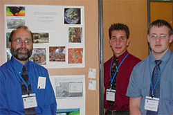
It was two years ago that Jensen, a high school geography teacher in Denmark, came to the United States to visit Moore, who teaches a class in geoscience and remote sensing at the Burlington County Institute of Technology in Medford, N.J. The two of them got to talking, and soon developed a plan for the following school year: Both would have their classes conduct topical Earth science investigations involving real-world data and geographic information systems. Then, each would travel with two students to the other teacher's school to present the work done back home.
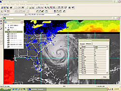
Moore's class examined how GIS, in conjunction with NASA satellite imagery, aerial photography, population data, topographic maps and weather observations, could aid decision-makers responding to a hypothetical tanker explosion. In a second study, the Burlington students tracked a hurricane using data from satellites, ocean buoys and other sources.
Meanwhile, in Denmark, Jensen's students combined GIS with soil, elevation, land-use and other data to determine whether agricultural activities were contaminating the local groundwater supply.
GIS -- tools that allow for the layering and visualization of diverse datasets -- provides the common thread needed to integrate the many forms of real-time data that now exist, according to Moore.

|
"Displaying data in a visual format is a user-friendly way to make decisions and communicate sometimes complicated problems to the public," he said.
While introducing students to the power of GIS was a major goal of the projects themselves, the most important lessons may have been learned after the projects were completed, during the students' visits abroad.
"It was a great inspiration to the students to meet each other and show what they had achieved and learned," Jensen said. "The educational value of sharing and collaboration can not be underestimated."
Justin Davison and Darryl Dorofy, the two high school seniors who accompanied Moore to Denmark, enjoyed demonstrating and seeing how similar kinds of data and tools could be applied to different scenarios in different countries.

|
"We would show [the Denmark students] our projects and also give them examples of how they could use GIS in their everyday life," Davison said.
"What we had the opportunity to do was actually show them another part of the world using tools and sources of data that they were familiar with," added Dorofy.
Moore credits GLOBE, sponsored by NASA and the National Science Foundation, in which students around the world gather environmental data and report their measurements via the World Wide Web, with providing an infrastructure for young scientists to collect data locally, and share globally. (GLOBE observations played a role in both of the Burlington projects, and Jensen used to coordinate the GLOBE program in Denmark.)
"It is well accepted that most environmental problems are of a global nature," Moore said. "Therefore, their solutions are also global."
After traveling back and forth across the Atlantic, Dorofy and Davison have learned to appreciate the need that Moore speaks of for international communication and collaboration in science.
"It's important that the generation of tomorrow -- the students of today -- interact and communicate with each other," said Dorofy, now a freshman and math major at Burlington Community College. "We have a responsibility to preserve the planet in which we live, and the only way we can do so effectively is not acting independently of each other, but rather as a global community."
"I feel that it's important to be able to share environmental data," echoed Davison, who intends to continue studying and working with GIS when he starts at Rowan University in the fall. "It will create a greater understanding [of the environment] for students not only in the United States, but all over the world."
Moore says that it is natural for students involved in international science collaborations to broaden their view of the world, and to be motivated toward careers in science, technology, engineering and math, which is why he and Jensen are pursuing funding to support similar student exchanges in the years to come.
"Students that return from these experiences consistently have doubled their efforts, and their enthusiasm spreads to the others in the class," Moore said. "Often, students who have in the past struggled with academics gain new insight and inspiration."
See previous Earth Explorers articles:
+ View site
Related Resources
Using GLOBE Data to Study the Earth System
+ View site
Event-Based Science: Remote Sensing Activities
+ View site
GLOBE
+ View site