Feature
A DEVELOPing Story
08.05.04
| Who are NASA's Earth Explorers? The elementary school student questioning if El Niño occurs anywhere besides the Pacific Ocean. The researcher investigating connections between Arctic ozone depletion and global climate change. The citizen scientist interested in how changing land cover and use affects animal migration patterns. And the businessperson projecting future needs for harvest, delivery and storage of crops. All of these people are Earth Explorers - they are all connected by their curiosity about Earth system processes. This monthly series will introduce you to NASA Earth Explorers, young and old, with a variety of backgrounds and interests. Nominate an Earth Explorer! Do you know someone who would be a good subject for this series? We're looking for students, teachers, scientists and others who are working with NASA Earth science data and imagery to better understand our home planet. Send your nominations to Dan Stillman: dan_stillman@strategies.org. |

|
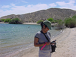
Image to right: Dyuti Sengupta, a member of the DEVELOP invasive species team and a geography student at San Jose State University, uses a handheld computer to mark the location of tamarisk in Nevada. Credit: NASA
Two research teams have been formed as part of DEVELOP, a NASA-sponsored internship program in which students conduct pilot projects that demonstrate to community leaders how Earth science data and technology can be applied to local policy issues.
Both teams are leveraging the power of NASA satellites, which can collect data over widespread and remote areas not easily observed by conventional means:
The Good and the Bad of Forest Fires

|
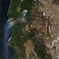
Image to left: Plumes of smoke from forest fires in Oregon stream southward over the Pacific Ocean. This image was acquired in August 2002 by the MODIS (Moderate Resolution Imaging Spectroradiometer) instrument on NASA's Terra satellite. Credit: NASA
Forests and fires play a significant role in the world's carbon cycle, and thus the phenomenon of global warming. By way of photosynthesis, trees, plants and other vegetation remove carbon from the air -- carbon that would otherwise combine with oxygen to form carbon dioxide, a greenhouse gas.
A burning forest, however, sends that carbon right back into the atmosphere, which is why small, purposely set fires are considered beneficial. Not only do they clear out the underbrush and dead vegetation that fuel massive, catastrophic wildfires capable of releasing large amounts of carbon, but they also recycle nutrients that restore the health of forest ecosystems.
The ability of a forest to store carbon is also affected by the age of the trees that are cut down, as younger trees absorb more carbon than older ones.

|
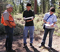
A DEVELOP team is assisting management at the Fremont-Winema National Forests in southern Oregon by generating predictions of carbon absorption and fire risk for different cutting and burn scenarios. The data and technology being used by the students include:
- Maps showing how much sunlight the forests are absorbing, produced by NASA's MODIS (Moderate Resolution Imaging Spectroradiometer) satellite instrument;
- Surface imagery from NASA's Landsat satellite;
- Regional climate data; and
- Computer models and decision support tools.
"It's interesting to see Earth science concepts applied to the real world, not just in the classroom or on a computer screen," said Kevin, who will start his freshman year at Stanford University this fall.
Battling Tamarisk

|
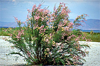
Image to left: The tamarisk may look friendly, but it's wreaking havoc with plant and animal life in Nevada and other parts of the southwestern United States. Credit: Steve Dewey, Utah State University
While its pink flowers and bright green branches may be aesthetically pleasing -- it was originally introduced as an ornamental plant from Asia -- the pesky weed drives out other vegetation and disrupts habitats by stealing water and depositing a salt residue into the soil. In addition, large concentrations of tamarisk increase the risk of fire and the intensity of downstream flooding.
All of this, combined with the plant's ability to spread quickly and survive in a variety of conditions, has land managers racing to stay one step ahead.
To help officials in the state of Nevada map, monitor and predict the spread of this invasive species, a DEVELOP team is integrating satellite observations, including Landsat imagery and data from NASA's MODIS and ASTER (Advanced Spaceborne Thermal Emission and Reflection Radiometer) instruments, with field data and soil measurements.
The resulting product will be a map showing the estimated present distribution of tamarisk throughout the study area. This information will then be incorporated into a national invasive species forecasting system being developed by the United States Geological Survey.
"It's fascinating to work with these technologies and see our work actually applied to real-world situations," said team member Shimon Kolkowitz, also a soon-to-be freshman at Stanford.
Both studies are scheduled to be completed in the fall and are being run out of DEVELOP's Western Regional Office at NASA Ames.
DEVELOP is a year-round program with projects conducted each academic term by teams across the country. Interested high school and college students must apply through the national program office at NASA Langley. Visit the Web site for more information: http://develop.larc.nasa.gov.
See previous Earth Explorers articles:
+ View site
Related Resources
Fire! Remote Sensing Activities
+ View site
Invasive Species Forecasting System
+ View site