Student Features
Into Africa
04.07.05
| Who Are NASA's Earth Explorers? The elementary school student wondering how El Niño will affect tomorrow's weather. The scientist studying connections between ozone and climate change. And the farmer using satellite pictures to keep track of crops. All of these people are Earth Explorers -- they are all curious about the Earth system. This monthly series will introduce you to NASA Earth Explorers, young and old, with many backgrounds and interests. Nominate an Earth Explorer! Tell us about the Earth Explorers you know. We're looking for students, teachers, scientists and others who are working with NASA Earth science data and imagery to better understand our home planet. Send your nominations to Dan Stillman: dan_stillman@strategies.org. |
 |
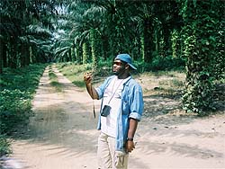
Image to left: Standing in a Ghanaian palm plantation, Johnson calculates his exact location with a global positioning system, or GPS receiver. Credit: Coppin State
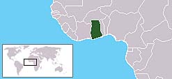
Unlike his ancestors, Adam Johnson visited the West African coast earlier this year by choice. Johnson is a student at Coppin State University in Baltimore, Md. He and his geography teacher, Douglas Reardon, traveled to Ghana. The two were there to get a close-up look at an area they had been studying from satellite images. Their trip was part of the school's "Middle Passage Project."
"Middle Passage" refers to the journey of slaves across the Atlantic Ocean. This voyage was considered the middle portion of a three-part trade route. In the first part, ships would carry goods from Europe to Africa. There, the goods were traded for slaves. Hundreds of slaves were packed like sardines onto a single ship. Next, it was off to the Americas -- the second part -- to drop off the slaves in exchange for other goods. The trip back to Europe was the third and final part.
 |
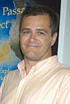
Image to right: Douglas Reardon is Adam Johnson's geography teacher. Credit: Coppin State
What have they found?
NASA satellite images show that many of the trees that once covered the land are now gone. They've been cut down to be used for wood. Farmers have replaced the trees with various plants and crops. An exception is Kakum National Park, which is still heavily forested. The park was created to protect the natural forest.
Satellites are pretty neat, but they don't always tell the whole story. Seeing the land in person helped Johnson and Reardon. It helped them distinguish between different kinds of plants and crops. As they walked around, they noted the exact location of certain types of land cover. A GPS unit helped them do this.
Back home, Johnson and Reardon are still hard at work. They're comparing satellite images with the data they collected in Ghana. Reardon plans to publish their findings in a science journal. He also plans to use the results to create lessons for his geography courses.
 |
This project is unique because it ties science together with black history. Many students at Coppin State are black. Reardon says that visiting Ghana was great for Johnson. He says that it gave Johnson a chance to see a place that played a key role in black history.
NASA's MU-SPIN sponsored the project. MU-SPIN stands for "Minority University-Space Interdisciplinary Project." It's a program that helps train minority students to be scientists and engineers.
It looks like Johnson will continue doing similar work after he graduates. Johnson is taking part in a program that will lead to a full-time job. He'll be working for the National Geospatial-Intelligence Agency.
Johnson says that he looks forward to a career in solving problems with satellites and other tools.
"The Earth is forever changing," he said. "We need people to constantly monitor those changes."
See previous Earth Explorers articles:
+ View site
Related Resources
Kids Science News Network™: How do satellites help us study Earth from space?
+ View site
Minority University-Space Interdisciplinary Project (MU-SPIN)
+ View site