- NASA Home
- | For Educators
- | Grades K-4
- | Featured Materials
Feature
The Chills and Thrills of Ice
08.27.07
Who Are NASA's Earth Explorers?
The elementary school student questioning if El Niño occurs anywhere besides the Pacific Ocean. The researcher investigating connections between Arctic ozone depletion and global climate change. The citizen scientist interested in how changing land cover and use affects animal migration patterns. And the businessperson projecting future needs for harvest, delivery and storage of crops. All of these people are Earth Explorers -- they are all connected by their curiosity about Earth system processes. This monthly series will introduce you to NASA Earth Explorers, young and old, with a variety of backgrounds and interests.
Nominate an Earth Explorer!
Tell us about the Earth Explorers you know. We're looking for students, teachers, scientists and others who are working with NASA Earth science data and imagery to better understand our home planet. Send your nominations to Dan Stillman: dan_stillman@strategies.org.
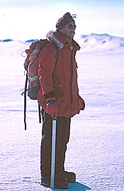
Few people know cold and ice like Robert Bindschadler does. As a leader of more than a dozen Antarctic field expeditions, the longtime NASA scientist has endured blizzards, slept in tents through bitter cold, and avoided falling into hidden cracks in glacial ice.

Robert Bindschadler explores ice all over the world.
Image Credit: Patricia Vornberger
"A lot of people think we're crazy for what we do," Bindschadler said. "Actually, the camping is a lot of fun, and I know of no other place so remote where you feel so close to nature."
Besides fulfilling his sense of adventure, Bindschadler has good reason for subjecting himself to such extreme elements. The study of icy environments has become one of the hottest fields in climate science. Warming global temperatures are melting ice at an alarming rate, in some cases faster and more suddenly than scientists expected.
This decade has seen the breaking or collapse of two major ice shelves -- the parts of glaciers that extend out over the ocean. In 2002, the Larsen B Ice Shelf, about the size of Rhode Island, broke off the Antarctic Peninsula's eastern coast. The piece of ice, which may have been around for 12,000 years, took just more than a month to disintegrate.
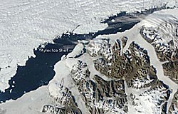
Also in 2002, the Ward Hunt Ice Shelf, along the north coast of Canada's Ellesmere Island, split in two. Ward Hunt is the largest ice shelf in the Arctic. Three years later, in 2005, the nearby Ayles Ice Shelf separated from Ellesmere. The Ayles Ice Shelf is now an island of ice, about the size of Manhattan, drifting in the Arctic Ocean.
Like many other polar scientists, Bindschadler seeks answers to important questions raised by a warming world: Where and how quickly will ice melt? How will this affect the movement of glaciers? How much and how fast will sea levels rise as a result? What will the impacts be on society, especially for coastal areas?
"We're getting closer to these answers. We know we’ll have less ice, but it'll be a few more years before we can predict the details," Bindschadler said. Already, the Intergovernmental Panel on Climate Change reports that glacial ice has likely contributed to an observed rise in global average sea level between 1961 and 2003.
The relationship between ice and sea level is not as simple as equating less ice to higher sea level. In fact, because ice shelves are already floating in the water, their melting does not cause sea level to rise, just like a melting ice cube doesn't raise the level of water in a glass. However, ice shelves do help to restrain downhill movement of the glaciers to which they are connected. Thus, the loss of an ice shelf allows glaciers to flow more quickly from land into the ocean, which raises sea level in the same way dropping an ice cube into a glass of water raises the height of the water.
Whether on land or at sea, the loss of ice due to warming can cause further warming and, consequently, additional melting of ice. This effect occurs because the land and ocean exposed under melted ice are darker in color than ice, so more solar radiation is absorbed and more heat is released into the atmosphere.
To investigate and better predict how ice is changing around the world, Bindschadler has explored glaciers in Washington state, Alaska, Switzerland and New Zealand, in addition to his trips to Antarctica. He has also traveled to Iceland and to the edge of Greenland's ice sheet.
When he's had enough of the bone-chilling cold, Bindschadler warms up in the cozy confines of NASA's Goddard Space Flight Center in Greenbelt, Md., where he uses satellites to learn more about glaciers and ice shelves. With satellites, Bindschadler can measure the movement of ice and changes in its area and thickness: Which begs the question, why brave the cold and ice in person when satellites can do the job remotely?

The MODIS instrument on NASA's Terra satellite captured this image of the Ayles Ice Shelf shortly after it separated from Canada's Ellesmere Island. Image Credit: NASA
The answer is that ground observations are needed periodically to validate satellite measurements. Moreover, some tasks are impossible to accomplish from space, such as drilling into ice to measure its thickness or sample the bedrock below, or using explosives to conduct seismic studies that reveal information about the geology of layers beneath the ice.Viewing ice from space and then from the ground is "a bit like seeing a fly with your eyes, wondering how it sees and flies, getting some ideas, but then having to look at it under a microscope to check out your ideas," Bindschadler said.
Antarctica's Pine Island Ice Shelf could be the next place to go under the proverbial microscope. A proposed project would take a team, led by Bindschadler, to what he calls "the most dangerous place I've ever worked," with lots of crevasses -- deep cracks in the ice -- and little room to land an airplane or set up camp.
The risks would be worth the reward, according to Bindschadler, whose team would melt a hole five inches in diameter through the 500-meter-thick ice shelf and drop down sensors to monitor the temperature, salinity and flow of the water below. Such data could help scientists improve their understanding of how heat is transferred from ocean waters to ice.
"When all is said and done, it is the scientific mysteries we are trying to solve that motivate me to make the trip and face the hazards," Bindschadler said.
NAME THAT ICE
Ice goes by different names depending on where and how it forms:Glaciers are large rivers of ice on land that move very slowly downhill. They form in snowy places that are cold enough year round to limit melting. As snow accumulates over many years, it packs down into thick masses of ice.
Extremely large glaciers -- more than 50,000 square kilometers (19,500 square miles) -- are called ice sheets. Only two ice sheets currently exist. One covers nearly all of Antarctica, with the other covering most of Greenland.
Ice shelves are those parts of glaciers that extend out over the ocean.
Icebergs are large pieces of ice floating in the ocean that have broken off from a glacier or ice shelf.
Sea ice is frozen ocean water.
Related Resources
NASA & the International Polar Year
POLAR-PALOOZA →
Tour of the Cryosphere
Previous Earth Explorers Articles
Dan Stillman, Institute for Global Environmental Strategies