 |
|---|
Data Access |
Data Production and Distribution Status
 |
All systems nominal
NOTE: FTP connections must be made in PASSIVE mode |
|
|
| Visually search the ocean color data archive. Directly download or order data from a single file to an entire mission. |
| Browse the entire global ocean color data set for many parameters and time periods and download PNG images or digital data in HDF format. |
| Time series plots of selected SeaWiFS, MODIS and OCTS Standard Mapped Images for a set of selected regions or the entire globe. |
| The FTP access to our most popular data products, including the complete Level 3 data archive. |
| Ocean Net Primary Productivity data products derived from MODIS and/or SeaWiFS data available from Oregon State University. |
| An easy-to-use, Web-based interface for the visualization and analysis of Earth Science data provided by the GES DISC DAAC. |
|
 |
|
 |
|---|
Ocean Color Web Feature |
Recent topics and imagery of interest to the OceanColor community.
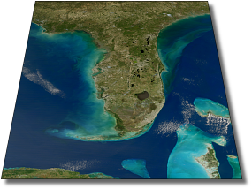
Southeastern United States

It is a rare day when the entire coastline of the southeastern United States
is cloud free at the same moment. January 9, 2009 was nearly such a day, and,
from the perspective of the MODIS instrument on the Aqua satellite, the ocean
also happened to be sunglint free at the same time. This is usually a winning
combination from the perspective of a remote-sensing, ocean-color scientist.
Click on the above image to see the coastal waters from Ocean City, Maryland
to New Orleans, Louisiana. A still higher resolution
35 megabyte version
is also available.
|
|
|
|
|
|
|
NOTE: All SeaWiFS images presented here are for research and educational use only. All commercial use of SeaWiFS data must be coordinated with GeoEye |
| |
|
 |
|---|
Support Services |
A comprehensive image analysis package for the processing, display, analysis, and quality control of ocean color data.
|
An archive of in situ oceanographic and atmospheric data for use in algorithm development and satellite data product validation.
|
Near Real-Time (NRT) Services: - NRT Data Subscriptions
Subscriptions allow users to specify regions for NRT data to be continually staged on our FTP server for download. Information Services: Other Services: |
|
|
|
|
|
 |
|


