

 / Climate Monitoring / 2006 / ENSO / Help / Climate Monitoring / 2006 / ENSO / Help

|

|
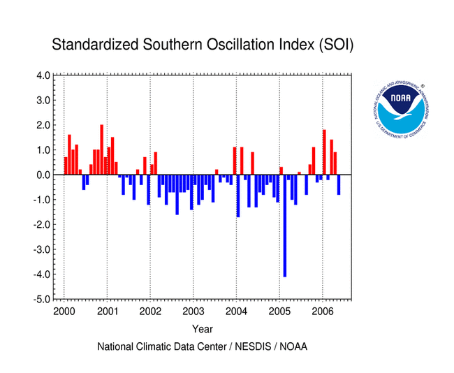
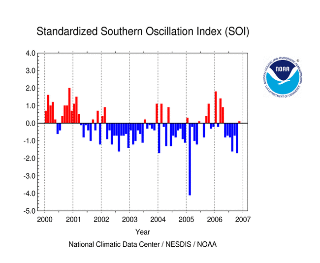
OCEANIC CONDITIONS: The El Niño/Southern Oscillation (ENSO) began 2006 in a weak cold phase (i.e., weak La Niña), which had begun developing during November and December of 2005. During the first four months of 2006, below average sea-surface temperature (SST) anomalies were observed in the central and eastern equatorial Pacific Ocean, with the coldest SST anomalies measured in January in the Niño 3.4 region. By April and May 2006, the near-equatorial SST anomalies had warmed to near-normal in the central Pacific region as the ENSO transitioned to a neutral phase. In the western equatorial Pacific, SST anomalies increased to above-average in May, and have continued to warm throughout the remainder of 2006. This can be seen in the monthly averaged SST anomalies in the Niño 4 region. By the beginning of September 2006, rapid warming in the upper-ocean along the equatorial zone in the Pacific basin was the first indicator that an ENSO warm event (i.e., El Niño) had begun to develop. This was clearly evident in the monthly averaged SSTs in the Niño 3.4 region where the September anomaly increased to above-normal. The pronounced warming of the upper ocean and mixed-layer temperatures during the latter half of 2006 was reflected in the classical El Niño region of the eastern Pacific and along the South American coast (i.e. the Niño 1+2 region). The warming of the eastern equatorial Pacific SSTs began as early as July, although there had been a temporary period of warming in late February and March as the 2005/2006 La Niña dissipated. Since April, four oceanic Kelvin wave events have propagated across the Pacific basin, with each subsequent Kelvin wave gaining amplitude. The two most recent Kelvin waves (visible in this Jason-1 sea level anomaly animation) have significantly aided in the suppression of equatorial upwelling in the eastern equatorial Pacific, allowing warm water anomalies to further develop at the surface and in the mixed-layer. By the end of November, these warm anomalies had increased to well above average, with SSTs significantly above normal in all of the Niño regions across the equatorial Pacific basin. By the end of 2006, the El Niño event had reached maturity. SST anomalies were greater than +1.0°C (+1.8°F) across the equatorial Pacific, with monthly averaged anomalies exceeding +1.5°C (+2.7°F) in parts of the central and eastern Pacific. Sub-surface temperature anomalies were significantly warmer than normal, although a layer of cooler water that developed just below the mixed-layer in the western Pacific in November spread eastward in December. SST anomalies in the Niño regions remained warmer than normal in December, although there was a significant decrease in the SST anomalies observed in the Niño 1+2 region along the South American coast during the month. This recent cooling in the Niño 1+2 region during December has prompted NOAA's Climate Prediction Center (CPC) to indicate in their most recent ENSO Diagnostic Discussion that the warm event had reached maturity and has shown signs of weakening at the end of the year. ATMOSPHERIC CONDITIONS: The Southern Oscillation Index (SOI) reflected the transition from a weak La Niña to a moderate El Niño during 2006. During the first half of the year, the SOI was primarily positive, reflecting the relatively weak La Niña conditions in the Pacific basin. The largest positive monthly SOI value was observed during January, when the SOI jumped near +2. However, this was relatively short-lived as the monthly SOI values fluctuated between near-neutral and positive over the next few months. Beginning in May, there were six consecutive months of negative SOI values in the equatorial Pacific, as ENSO transitioned from a neutral phase to an El Niño warm event. However, uncharacteristic of El Niño conditions, the November SOI was near-neutral, with a value of +0.1 for the monthly average. At the beginning of 2006, the Outgoing Longwave Radiation (OLR) Index was positive; tropical convection was suppressed across the equatorial Pacific in response to the cold SSTs that had developed in association with the weak La Niña present at that time. However, this changed significantly in June when the OLR Index had a negative value for the month, breaking a string of ten consecutive months with positive OLR Indices associated with the 2005/2006 La Niña. Subsequently, the OLR Index was negative for the next four months, and in October the index declined to -0.8, which was the lowest value for the year. The most recent monthly averaged OLR Index was again negative, but with a near-neutral value of -0.2 in November. At the end of 2006, as the El Niño event persisted in the oceanic mixed-layer, both the SOI and the OLR Index had lagged the warming ocean conditions. As of early January 2007, the atmospheric indicators had yet to respond basin-wide to the development of warmer-than-normal SSTs in the equatorial Pacific. In fact, both the OLR Index and the SOI were near-neutral during November. The situation remained similar in December, although the SOI had shifted sign back to a negative value representative of the warm event conditions. KEYWORDS: ENSO; Niño Regions; Southern Oscillation Index (SOI); Kelvin Waves; Thermocline; Sea-Surface Temperatures (SSTs); Madden-Julian Oscillation (MJO); Walker Circulation |
 ENSO Links
Questions?
| For all climate questions other than questions concerning this report, please contact the National Climatic Data Center's Climate Services Division: |
|
|
For further information on the historical climate perspective presented in this report, contact: |
-or-
|
NCDC / Climate Monitoring / 2006 / ENSO / Help


