MISSIONS
Mission Details
The agreement in 1987 between CNES and NASA to join resources and expertise on the
TOPEX/Poseidon Project culminated 20 years of development into using a spaceborne
radar altimeter to measure ocean-surface topography.
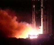 TOPEX/Poseidon was launched August 10, 1992 from the ESA launch facility at Kourou,
French Guiana, aboard an Ariane 42P launch vehicle.
TOPEX/Poseidon data has revolutionized the way the global ocean is studied.
For the first time, the seasonal cycle and other temporal variabilities of
the ocean have been determined globally with high accuracy, yielding fundamentally
important information for testing ocean circulation models. Many major observations
were made using TOPEX/Poseidon data.
TOPEX/Poseidon was launched August 10, 1992 from the ESA launch facility at Kourou,
French Guiana, aboard an Ariane 42P launch vehicle.
TOPEX/Poseidon data has revolutionized the way the global ocean is studied.
For the first time, the seasonal cycle and other temporal variabilities of
the ocean have been determined globally with high accuracy, yielding fundamentally
important information for testing ocean circulation models. Many major observations
were made using TOPEX/Poseidon data.
Recognizing the importance of continuing ocean surface topography measurement,
NASA and CNES approved Jason-1 as a joint follow-on to
TOPEX/Poseidon.
Nine years of scientific discovery by TOPEX/Poseidon broadened its original
list of science objectives.
 Jason-1 flies as a joint CNES/NASA follow-on to TOPEX/Poseidon. The CNES-supplied
spacecraft carries a payload of five instruments: the POSEIDON-2 altimeter, the
mission's main instrument, to measure altitude; the Jason Microwave Radiometer to
measure perturbations due to atmospheric water vapor; and the three location-finding
systems used so successfully in TOPEX/Poseidon: the DORIS Doppler orbitography beacon,
the laser retroreflector array, and the advanced-model TRSR, the "GPS-on-a-chip"
BlackJack GPS receiver. These instruments provide full redundancy and
measurements for at least 5 years. Jason-1 was launched from Vandenberg AFB
aboard a NASA-supplied Delta rocket on December 7, 2001.
After TOPEX/Poseidon was decommissioned in January 2006,
Jason-1 has continued the task of providing the important
oceanographic data time-series originated by its predecessor.
Jason-1 flies as a joint CNES/NASA follow-on to TOPEX/Poseidon. The CNES-supplied
spacecraft carries a payload of five instruments: the POSEIDON-2 altimeter, the
mission's main instrument, to measure altitude; the Jason Microwave Radiometer to
measure perturbations due to atmospheric water vapor; and the three location-finding
systems used so successfully in TOPEX/Poseidon: the DORIS Doppler orbitography beacon,
the laser retroreflector array, and the advanced-model TRSR, the "GPS-on-a-chip"
BlackJack GPS receiver. These instruments provide full redundancy and
measurements for at least 5 years. Jason-1 was launched from Vandenberg AFB
aboard a NASA-supplied Delta rocket on December 7, 2001.
After TOPEX/Poseidon was decommissioned in January 2006,
Jason-1 has continued the task of providing the important
oceanographic data time-series originated by its predecessor.
Jason-1 is the first in a 20-year series of satellites to continue the
TOPEX/Poseidon mission. Jason-1 is integrated into international climate-study
programs, provides near real-time data access, and marks the beginning of
the operational era of collecting these oceanographic parameters. The next in the altimeter series, the Ocean Surface Topography Mission, was launched in June 2008.
|