QuikSCAT
Full Name: Quick Scatterometer
Phase: Operating
Launch Date: June 19, 1999
Mission Project Home Page: http://winds.jpl.nasa.gov/missions/quikscat/
Program(s): Earth Systematic Missions
QuikSCAT mission is intended to record sea-surface wind speed and direction data under all weather and cloud conditions over Earth's oceans. QuikSCAT was initiated as a "quick recovery" mission to help reduce the ocean-wind vector data gap created by the loss of the NASA Scatterometer (NSCAT) on the Japanese Advanced Earth Observing Satellite (ADEOS), which ceased functioning when ADEOS failed on June 30, 1997. QuikSCAT was launched from Vandenberg Air Force Base, Calif., aboard a Titan II vehicle, reducing the data gap by about one-half.
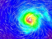
The QuikSCAT ocean-viewing satellite captured this image of Hurricane Dora in the eastern tropical Pacific Ocean on August 10, 1999 as it was blowing at speeds of nearly 40 meters per second (90 miles per hour). The image shows surface wind speed (colored background) and wind direction (arrows) in the vicinity of the hurricane, which was centered near 14.5 degrees north latitude and 117.8 degrees west longitude.
QuikSCAT operates in a near polar orbit. It flies in a circular orbit at an altitude of approximately 800 km (500 miles) above Earth's surface. It completes a full orbit in about 101 minutes, which translates to a little more than 14 orbits per day.
SeaWinds is the main instrument on the QuikSCAT satellite. SeaWinds is an active radar scatterometer. This scatterometer operates by transmitting high-frequency microwave pulses to the ocean surface and measuring the echoed radar pulses bounced back to the satellite. The scatterometer estimates wind speed and direction over the Earth's oceans at 10 m above the surface of the water. The instrument collects data over ocean, land, and ice in a continuous, 1,800-kilometer-wide band, making approximately 400,000 measurements and covering 90% of Earth's surface in one day. QuikSCAT can acquire hundreds of times more observations of surface wind velocity each day than can ships and buoys, and can provide continuous, accurate and high-resolution measurements of both wind speeds and direction regardless of weather conditions. This data is vital for global climate research, operational weather forecasting, and storm warning.
The SeaWinds scatterometer is providing unprecedented, frequent surface wind speed and direction measurements over the global oceans. Coupled with other satellite measurements of cloud patterns, water vapor and rain, the data are contributing to scientists' ability to predict the intensity, location and movements of hurricanes and other severe marine weather patterns.