Terra
Full Name: TERRA
Phase: Operating
Launch Date: December 18, 1999
Mission Project Home Page: http://terra.nasa.gov/
Program(s): Earth Systematic Missions
Terra (formerly EOS AM-1) is the flagship satellite of NASA's Earth observing systems. Terra is the first EOS (Earth Observing System) platform and provides global data on the state of the atmosphere, land, and oceans, as well as their interactions with solar radiation and with one another.
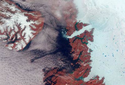
Vibrant reds, emerald greens, brilliant whites, and pastel blues adorn this view of the area surrounding the Jakobshavn Glacier on the western coast of Greenland. The image is a false-color (near-infrared, green, blue) view acquired by the MISR's nadir camera. The brightness of vegetation in the near-infrared contributes to the reddish hues; glacial silt gives rise to the green color of the water; and blue-colored melt ponds are visible in the bright white ice.
MODIS will measure the atmosphere, land and ocean processes, (including surface temperature of both the land and ocean), ocean color, global vegetation, cloud characteristics, temperature and moisture profiles, and snow cover. It will view the entire surface (land, oceans, clouds, aerosols, etc.) of the Earth every 1-2 days at a "moderate resolution" of one-quarter to one kilometer.
Since the 1950's, it has become increasingly clear that human activities are modifying the composition of the atmosphere on a global scale. As the result of industrialization, the concentration of carbon dioxide has increased by about 20% during this period. More recently, the stratospheric concentrations of chemically-active gases containing chlorine, bromine, and fluorine have dramatically increased. These trends have created issues of global interest including global warming and declining levels of ozone (both globally and in the ozone "hole" in the Antarctic). It has become increasingly clear, however, that these processes do not occur independently of one another and can only be understood in the context of a global system. Accurate and precise measurements are needed to unravel complex and interactive relationships between chemical, radiative, and dynamical processes in the atmosphere, ocean, and on land. As a result, in 1991 NASA initiated a comprehensive program to understand the Earth's atmosphere, oceans, land, and cryosphere (ice and snow) as a single, complex, interactive system. NASA's Earth Observing System (EOS) consists of a series of spaceborne instruments to monitor crucial components of the Earth system, an advanced data handling system, and teams of scientists who will evaluate on-going climate change and predict future changes. Ultimately, EOS will produce scientifically sound recommendations for environmental policy to national and international bodies to mitigate or prepare for these changes.
October 2003's massive wildfires in Southern California stripped the ground of the vegetation that holds dirt in place. The freshly exposed soil and the overlying ashes are vulnerable to winds, as this true color MODIS image shows. Here, a tan plume of dust and ash is blowing over the Pacific Ocean and San Clemente Island. In this image, newly burned areas are dark brown against the tan of the surrounding land. The sprawling grey patch along the coast is Los Angeles. Beneath the dust plume, a smaller grey area is the city of San Diego. The dust is clearly coming from the burn scar left by the Cedar fire near San Diego. The Terra satellite captured this image on November 27, 2003.
The MOPITT instrument, provided by the Canadian Space Agency, will map carbon monoxide and methane concentrations at altitudes between 10 miles and the ground. MOPITT is an infrared gas correlation radiometer and will produce maps over the entire globe every 4-16 days. From these measurements the sources, motions and sinks of these gases can be determined.
On February 24, 2000, Terra began collecting what will ultimately become a new, 15-year global data set on which to base scientific investigations about our complex home planet. Terra simultaneously studies clouds, water vapor, aerosol particles, trace gases, terrestrial and oceanic properties, the interaction between them and their effect on atmospheric radiation and climate. Moreover, Terra will observe changes in Earth's radiation budget (a measurement of all the inputs and outputs of the Earth's radiative energy), together with measurements of changes in land/ocean surface and interaction with the atmosphere through exchanges of energy, carbon, and water. Comprehending these interactive processes is essential to understanding global climate change.
A polar-orbiting spacecraft, Terra was launched aboard an Atlas-Centaur IIAS expendable launch vehicle from Vandenberg Air Force Base. Because Terra emphasizes observations of terrestrial surface features, its orbit is designed to cross the equator at this time when cloud cover, which obscures the land surface, is at its daily minimum. The orbit will be adjusted so that it covers the complete Earth every 16 days. This orbit will be maintained with periodic adjustments during the six-year life of the mission.
The five instruments onboard Terra include the Clouds and the Earth's Radiant Energy System (CERES), the Multi-angle Imaging SpectroRadiometer (MISR), the Moderate- Resolution Imaging Spectroradiometer (MODIS), the Measurements of Pollution in The Troposphere (MOPITT), and the Advanced Spaceborne Thermal Emission and Reflection Radiometer (ASTER) instrument.
The CERES instruments perform measurements of the Earth's "radiation budget," the process that maintains a balance between the energy that reaches the Earth from the Sun, and the energy that goes from Earth back out to space. The critical components that affect the Earth's energy balance are the planet's surface, atmosphere, aerosols, and clouds.
For the first time, policymakers and scientists now have a way to identify the major sources of air pollution and to closely track where the pollution goes, anywhere on Earth. The false colors in these images represent levels of carbon monoxide in the lower atmosphere, ranging from about 390 parts per billion (dark brown pixels), to 220 parts per billion (red pixels), to 50 parts per billion (blue pixels).
The ASTER instrument, provided by Japan's Ministry of International Trade and Industry, will measure cloud properties, vegetation index, surface mineralogy, soil properties, surface temperature, and surface topography for selected regions of the Earth.
CERES measured thermal radiation or heat emitted from the United States, as shown in this image from May 2001. The record-setting high temperatures experienced in Southern California and Nevada on May 9 are visible in the yellow areas where great amounts of thermal energy are escaping to space. The levels of energy increase from blue to red to yellow. This example illustrates one of the most basic stabilizing forces in the Earth's climate system: clear hot regions lose more energy to space than cold areas. The blue regions of low thermal emission over the northern U.S. are cold cloud tops. CERES data will be used to verify the ability of climate models to accurately predict this emission as our world experiences changes in surface reflectivity, clouds, atmospheric temperatures, and key greenhouse gases such as water vapor.
MISR will measure the variation of surface and cloud properties, and particles in the atmosphere, with cameras pointed in nine simultaneous different viewing directions. MISR will monitor monthly, seasonal, and long-term interactions between sunlight and these components of Earth's environment. Over a seven-minute period, points on the Earth within a 224 mile (360 kilometer) wide swath will be observed successively at all nine angles.
Every 1 to 2 days, Terra will use the unique perspective from space to observe the Earth's continents, oceans, and atmosphere with measurement accuracy and capability never before flown. Hundreds of scientists from the U.S. and abroad are prepared to take full advantage of Terra observations to address key scientific issues and their environmental policy impacts.
ASTER captured this image of the Old Fire/Grand Prix fire burning on either side of Interstate 15 near the Cajon Pass in the San Bernardino Mountains 80 km east of Los Angeles. The fire had burned over 80,000 acres, consumed 450 structures, and caused 2 fatalities. Most of the local communities were evacuated as the fire continued to spread.
The Terra Project Office, located at Goddard, manages Terra development for NASA's Office of Earth Science in Washington, D.C. Goddard is responsible for the development of the satellite and the development and operation of the ground operations system. Spacecraft operations will be performed at a Mission Operations Center at Goddard.