Clementine
Full Name: Clementine
Phase: Past
Launch Date: January 25, 1994
Mission Project Home Page: http://msl.jpl.nasa.gov/QuickLooks/clementineQL.html
Clementine was jointly sponsored by the Ballistic Missile Defense Organization (BMDO) and NASA as the Deep Space Program Science Experiment (DSPSE). The principal objective was to space qualify lightweight imaging sensors and component technologies for the next generation of Department of Defense (DOD) spacecraft. Intended targets for these sensors included the Moon, a near-Earth asteroid (1620 Geographos), and the spacecraft's interstage adapter.
After entering lunar orbit, Clementine providing over 1.6 million images of the Moon's surface. After the lunar mapping phase was completed, the spacecraft left lunar orbit for a planned encounter with Geographos, but was unable to rendezvous due to a spacecraft anomaly.
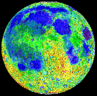
Image of the Moon's topography from Clementine's laser altimetry (red = high; purple = low). Image processing by Brian Fessler and Paul Spudis, LPIK
The Clementine imaging experiment revealed permanently shadowed areas at the bottom of deep craters near the Moon's south pole. In fact, it appears that approximately 6000 to 15,000 square kilometers (2300 to 5800 square miles) of area around the south pole is permanently shadowed. Much of the area around the south pole is within the South Pole-Aitken Basin (shown at left in blue on a lunar topography image), a giant impact crater 2500 km (1550 miles) in diameter and 12 km deep at its lowest point. Many smaller craters exist on the floor of this basin. Since they are down in this basin, the floors of many of these craters are never exposed to sunlight. Within these craters the temperatures would never rise above about 100 K (280 degrees below zero F). Any water ice at the bottom of the crater could probably exist for billions of years at these temperatures.
Image Credit: Ingersoll 1992
The mission had two phases. After two Earth flybys, lunar insertion was achieved approximately one month after launch. Lunar mapping took place over approximately two months, in two parts. The first part consisted of a five hour elliptical polar orbit with a periapsis of about 400 Km at 30 degrees south latitude and an apoapsis of 8300 Km. Each orbit consisted of an 80 minute lunar mapping phase near periapsis and 139 minutes of downlink at apoapsis.
After one month of mapping the orbit was rotated to a periapsis at 30 degrees north latitude, where it remained for one more month. This allowed global imaging and altimetry coverage from 60 degrees south to 60 degrees north, over a total of 300 orbits.
After a lunar/Earth transfer and two more Earth flybys, the spacecraft was to head for Geographos, arriving three months later for a flyby, with a nominal approach closer than 100 Km. Unfortunately, on May 7, 1994, after the first Earth transfer orbit, a malfunction aboard the craft caused one of the attitude control thrusters to fire for 11 minutes, using up its fuel supply and causing Clementine to spin at 80 rpm. Under these conditions, the asteroid flyby could not yield useful results, so the spacecraft was put into a geocentric orbit passing through the Van Allen radiation belts to test the various components on board.
The mission ended in June 1994 when the power level onboard dropped to a point where the telemetry from the spacecraft was no longer intelligible.
NASA funded a number of science grants using Clementine data.