 |
Stennis Space Center
2001 Phase 2
Web-Based Hurricane Storm Surge & Flood Forecasting
WorldWinds Inc.
Picayune, MS |
INNOVATION
- Automated software algorithm that produces bare earth Digital Elevation Models (DEM) using “variational analysis”
- Variational analysis computes the most probable estimate from a variety of data sources. It makes more accurate storm surge models possible
|
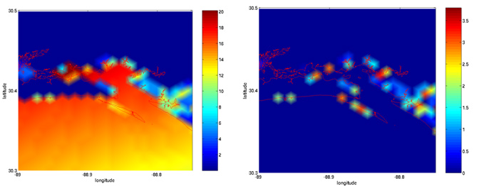
AD CIRC computed storm surge for
Hurricane Camille using optimized
bare-earth DEM for Eastern Biloxi Bay
|
Absolute difference (in feet) for the Hurricane Camille storm surge simulation using optimized bare-earth DEM vs. USGS DEM
|
|
ACCOMPLISHMENTS
- WorldWinds is currently incorporating the new bare earth results in the Coupled Ocean Atmosphere Mesoscal
- WorldWinds will replace the topographic datasets within COAMPS, coupled with ADCIRC, a storm surge model developed by the Army Corps of Engineers, to create new storm surge atlases
|
COMMERCIALIZATION
- WorldWinds is partnering with Intermap Technologies to incorporate its algorithm into Intermap products for the orthorectification of satellite and airborne imagery
- WorldWinds is selling output from the COAMPS weather model to be transmitted over XM Satellite via a subscription service, with mariners as the primary audience
|
GOVERNMENT/SCIENCE
APPLICATIONS- Variational analysis has been successfully applied to geosciences, meteorological, and engineering applications within the NASA Earth Science Directorate
- Federal and state agencies are evaluating the technology for use in evaluating rainfall effects, flash flood mapping, overlaid roads, and detailed coastline information
|
For more
information about this firm, please send e-mail to company
representative
Return
to NASA SBIR Success Listings
|
Software
Curator: SBIR
Support 12/08/08 |
