|

MONSOON, LA NINA BRING HEAVY RAINS,
FLOODING TO NORTHERN AUSTRALIA
Over the past two weeks, torrential rains have brought both drought relief as
well as severe flooding to parts of Queensland and the Northern Territory in
northern Australia. The wet weather was due primarily to the start of the
monsoon, a seasonal phenomenon wherein an area of low pressure forms over a
large land mass, in this case the Australian continent, during local summer.
Because of the large heat capacity of water, land heats up much faster than
water. This forces air to rise over the hotter land surface, which induces
low pressure to form at the surface. The low pressure in turn then draws
moist air in from the surrounding ocean, becoming a focus for shower and rain
activity.
|

(Click to see improved resolution)
|
|
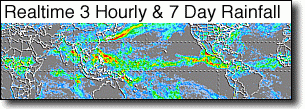
Armed with an array of active and passive sensors, the primary objective of
the Tropical Rainfall Measuring Mission satellite (better known as TRMM) is to
measure rainfall from space. For increased coverage, TRMM can be used to
calibrate rainfall estimates from other additional satellites. The TRMM-based,
near-real time Multi-satellite Precipitation Analysis (TMPA) at the NASA
Goddard Space Flight Center monitors rainfall over the global Tropics. TMPA
rainfall totals are shown here for the 2-week period 24 December 2008 to 7
January 2009 for Australia and the surrounding region. The most prominent
feature is an northwest-southeast band of very heavy rain that lies just inland
from the coast across central northern Australia. The band extends from the
western edge of the Northern Territory in the west to the base of the York
Peninsula in the east. Rainfall totals within this band are regularly in
excess of 300 mm (~12 inches, shown in orange) with embedded areas of even
higher amounts on the order of 400 mm (~16 inches, shown in red).
|

(Click to see improved resolution)
|
|
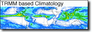
In addition to the monsoon, there is another key phenomenon at work: La Nina,
the counterpart to El Nino. Instead of above normal ocean temperatures in the
central and eastern Pacific and below normal values in the western Pacific,
La Nina brings the opposite. This results in enhanced rainfall over the western
Pacific, Maritime Continent, and northern and eastern Australia as enhanced
trade winds pile up even warmer waters in the West Pacific region. The last
image shows TMPA rainfall anomalies for this same 2-week period in relation to
the 10-year average for the same portion of the seasonal cycle. Above average
rainfall (shown in green and blue) extends from northern and eastern Australia
northward towards the Maritime Continent. This pattern is consistent with the
broad-scale rainfall signature for La Nina. The strong positive rain anomalies
(shown in bright blue) indicate that this rain event is rather significant for
this time of year.
|
Images by Hal Pierce(SSAI/NASA GSFC) and Captions by Steve Lang(SSAI/NASA GSFC)
SEE EXTREME EVENTS ARCHIVES
|


(July 9, 2007) Google Earth Downloads
|


