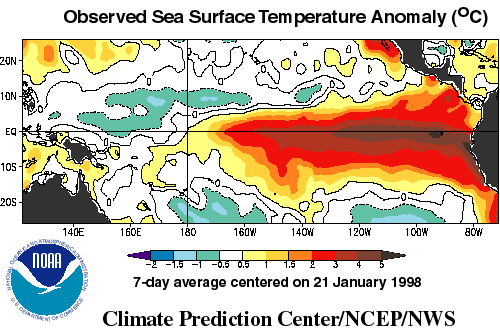
 Altimeter data is being used in long term forecasting as part of a
suite of data used as input into models. Other data sources are
satellite sea surface temperature measurements, and in-situ
measurements from buoys and drifters. Sea surface height data,
obtained by altimeters, relates to the temperature of the ocean
in that a 1 cm change in the height corresponds to a one degree
Celsius change in the ocean temperature over 50 meters. Changes
in the distribution of heat in the ocean affects the pattern of
evaporation and resultant precipitation. Because of the size of
the ocean, and its slow rate of change, the ocean affects climate
as well as weather (weather refers to short term events and
climate refers to long term trends.)
Altimeter data is being used in long term forecasting as part of a
suite of data used as input into models. Other data sources are
satellite sea surface temperature measurements, and in-situ
measurements from buoys and drifters. Sea surface height data,
obtained by altimeters, relates to the temperature of the ocean
in that a 1 cm change in the height corresponds to a one degree
Celsius change in the ocean temperature over 50 meters. Changes
in the distribution of heat in the ocean affects the pattern of
evaporation and resultant precipitation. Because of the size of
the ocean, and its slow rate of change, the ocean affects climate
as well as weather (weather refers to short term events and
climate refers to long term trends.)
NOAA and the International Research Institute for Climate Prediction
 Work on climate change is being done by NOAA
at their Climate Diagnostics Center,
in conjunction with the
NOAA Laboratory for Satellite Altimetry . Work is also in progress
at the International Research Institute for Climate Prediction,
a consortium that also involves NOAA.
Work on climate change is being done by NOAA
at their Climate Diagnostics Center,
in conjunction with the
NOAA Laboratory for Satellite Altimetry . Work is also in progress
at the International Research Institute for Climate Prediction,
a consortium that also involves NOAA.
Value of Predictions
The value of these predictions is that El
Niño and La Niña conditions, phenomena
where there are large scale changes in the distribution of
heat in the ocean, are associated with disruptions in weather
and climate. Knowing this ahead of time, appropriate
precautions can be taken such as clearing drainage channels
in areas likely to flood, or planting drought resistant crops
in areas likely to experience drought.