|


Mission |
 |
||||||||||||||||||||||||||||||||||||||||||||||||||||||||||||||||||||||||||||||||||||||||||
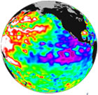
TOPEX/Poseidon observation of La Niña 2000 January 08. |
|||||||||||||||||||||||||||||||||||||||||||||||||||||||||||||||||||||||||||||||||||||||||||
| ANNOUNCEMENT: Congratulations to NASA, NOAA, CNES & Eumetsat on Its' Successful Launch of OSTM/Jason2! | |||||||||||||||||||||||||||||||||||||||||||||||||||||||||||||||||||||||||||||||||||||||||||
|
|||||||||||||||||||||||||||||||||||||||||||||||||||||||||||||||||||||||||||||||||||||||||||
| Back to top | |||||||||||||||||||||||||||||||||||||||||||||||||||||||||||||||||||||||||||||||||||||||||||
Announcements |
|||||||||||||||||||||||||||||||||||||||||||||||||||||||||||||||||||||||||||||||||||||||||||
| Back to top | |||||||||||||||||||||||||||||||||||||||||||||||||||||||||||||||||||||||||||||||||||||||||||
| Temporal Resolution It takes approximately 10 days for TOPEX/Poseidon to complete a cycle that surveys the entire Earth. Each cycle consists of 254 passes, which is half an orbit around the Earth and contains ~56 minutes of data. There is ~1 second between measurements. Spatial resolution |
|||||||||||||||||||||||||||||||||||||||||||||||||||||||||||||||||||||||||||||||||||||||||||
| Back to top | |||||||||||||||||||||||||||||||||||||||||||||||||||||||||||||||||||||||||||||||||||||||||||
| Documentation TOPEX/Poseidon Mission: http://topex-www.jpl.nasa.gov/mission/topex.html Altimeter Ocean Pathfinder (NASA/GSFC): ftp://podaac.jpl.nasa.gov/pub/documents/dataset_docs/altimeter_ocean_pathfinder.html |
|||||||||||||||||||||||||||||||||||||||||||||||||||||||||||||||||||||||||||||||||||||||||||
| Back to top | |||||||||||||||||||||||||||||||||||||||||||||||||||||||||||||||||||||||||||||||||||||||||||
| Known Problems and Issues There are times when the TOPEX/Poseidon satellite entered safehold-mode, and no data was collected as a result. A list of safing events is available at http://podaac.jpl.nasa.gov/DATA_CATALOG/tpsafehold.txt. The satellite also performed a series of maneuvers to ensure orbital accuracy. A list of maneuvers is available at http://podaac.jpl.nasa.gov/DATA_CATALOG/tp_maneuver.txt Various conditions, such as heavy rain or ice, may affect altimetric measurements. Known environmental and geophysical problems are flagged to allow researchers to easily evaluate these measurements. A description of the TOPEX/Poseidon flags is available in the TOPEX/Poseidon IGDR and GDR. ftp://podaac.jpl.nasa.gov/pub/sea_surface_height/topex_poseidon/mgdrb/doc/uhmgdrb/html/uhsec03.htm TOPEX-A altimeter operated from cycles 1-235. In mid 1997, it was determined that there was a degradation in the point target response which impacted the significant wave height. In February 1999, TOPEX-A was turned off and the redundant backup input titleimeter, TOPEX-B altimeter, was turned on. Subsequent calibration to assess the data resulted in keeping TOPEX-B on for cycle 236 and all subsequent cycles. Cycle 235 was the last cycle using TOPEX-A.
Early Pointing Angle Problems |
|||||||||||||||||||||||||||||||||||||||||||||||||||||||||||||||||||||||||||||||||||||||||||
| Back to top | |||||||||||||||||||||||||||||||||||||||||||||||||||||||||||||||||||||||||||||||||||||||||||
| Frequently Asked Questions http://podaac.jpl.nasa.gov/FAQ/index.html#altimetry |
|||||||||||||||||||||||||||||||||||||||||||||||||||||||||||||||||||||||||||||||||||||||||||
| Back to top | |||||||||||||||||||||||||||||||||||||||||||||||||||||||||||||||||||||||||||||||||||||||||||
Citations/References |
|||||||||||||||||||||||||||||||||||||||||||||||||||||||||||||||||||||||||||||||||||||||||||
| Back to top | |||||||||||||||||||||||||||||||||||||||||||||||||||||||||||||||||||||||||||||||||||||||||||
")
 (157)")
| Privacy/Copyright | User Services: podaac@podaac.jpl.nasa.gov | ||||
| Freedom of Information Act | All users publishing with PO.DAAC data from our providers and partners, please add a citation as outlined here. | ||||
|
|
|||||