|
|
|
|
 |
Mission
Jason-1 is an altimetric mission that measures significant wave height, mean sea surface, sigma0 (which can be converted to wind speed), and all the parameters needed to calculate sea surface height anomalies. It launched December 7, 2001 and began collecting data January 15, 2002 ( cycle 1). As of December 2007, Jason-1 has an orbit accuracy of ~2.5 cm and measures sea surface height with an accuracy of ~3.9 cm. A list of the Jason-1 cycles by date is available at: http://podaac.jpl.nasa.gov/DATA_CATALOG/j1_cyclelist.txt |
|
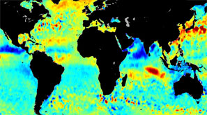 |
Sea Surface Height Anomalies during October
based on 6 years of Jason-1 Data (2002-2007).
|
|
|
|
|
|
|
|
|
 |
ANNOUNCEMENTS |
|
- Jason-1 Manuever Announcement |
| - Jason-1 IGDRs have a 1-second time tag error. Click here for more information. |
| - Temporary fix until entire Jason-1 mission is reprocessed to version C |
 |
JASON-1 Table
|
 |
 |
 |
 |
 |
 |
|
") |
FTP / HEFT |
s/w |
4-6 weeks |
x |
calc |
x |
Documentation:
User Manual / Abstract / References |
Comments: |
Most accurate and detailed product from Jason-1. Does not include SSHA, but this parameter can be calculated per the instructions in the Handbook. |
|
") |
FTP / HEFT |
s/w |
6 weeks |
x |
x |
x |
Documentation:
User Manual / Abstract / References
|
Comments: |
SSHA derived from the GDR product.
Data was adjusted to exclude values flagged in the GDR. |
|
") |
|
|
6 weeks |
- |
x |
- |
Documentation:
User Manual / Abstract / References |
Comments: |
An along track gridded version of the SSHA |
|
") |
|
|
2-3 days |
x |
calc |
x |
Documentation:
User Manual / Abstract / References
|
Comments: |
Similar to GDR. However, data are obtained in near real time and contain fewer corrections. Therefore, this product is less accurate than the GDR and should only be used if the GDR file is not yet available. |
|
") |
|
|
2-3 hr |
x |
- |
- |
Documentation:
User Manual / Abstract / References |
Comments: |
Near real time data intended for meteorological use. This product has the fewest corrections of the Jason-1 products. |
|
|
|
|
| Back to top |
|
Announcements
PO.DAAC Jason-1 Maneuver Announcement:
After more than 7 years of service on the nominal ground track, the Jason-1 satellite will be moved to a new interleaved orbit with OSTM/Jason-2 at the end of repeat cycle 259. The OSTM/Jason-2 satellite will continue the long term climate data record on the primary TOPEX/Poseidon--Jason-1--OSTM/Jason-2 ground track. Interleaving Jason-1 with OSTM/Jason-2 orbits will provide significant advantages for operational applications.
Beginning on 26 January 2009, several Jason-1 maneuvers will be performed to reach the new interleaved orbit by 9 February 2009. Due to altimeter limitations, no Jason-1 science data will acquired during this maneuver period and repeat cycles 260 and 261 will be lost.
Repeat cycle 262 will be the first Jason-1 cycle on the new interleaved ground track. The new orbit will be phased 162-degrees ahead of OSTM/Jason-2 with a time lag of approximately five days. This is the same interleaved orbit that was used by TOPEX/Poseidon from 2002-2005. The pass numbering within the cycle will also change to the pass numbering system that TOPEX/Poseidon used during its interleaved orbit phase.
Jason-1 OSDR production will resume shortly after the maneuvers are completed. Jason-1 IGDR and GDR products will become available after February 9, once the Project is confident of the accuracy of the new orbit calculations and tuning of POE models.
If you have any questions, please direct them to podaac@podaac.jpl.nasa.gov
Jason-1 IDGDRs tag error:
Please be advised that the JMR data on the Jason-1 IGDRs have a 1-second
time tag error from Cycle 241 Pass 181 to Cycle 248 Pass 187.
This error is caused by the Proteus platform GPS on Jason-1 erroneously
applying the upcoming leap second on July 29, 2008 instead of January 1, 2009.
Our thanks to Graham Quartly for observing this effect in comparisons
between JMR and AMR measurements.
This error will be corrected on the Jason-1 GDRs. Application of the
correction has caused a temporary delay in GDR-C processing for
Cycles 241 onwards.
Regards,
Shailen Desai
Nicolas Picot
Temporary fix until entire Jason-1 mission is reprocessed to version C:
Users are advised to note the following primary differences between the version B and version C Jason-1 GDRs.
1) Use of ITRF2005 reference frame and time variable gravity in precise orbits.
2) In improved sea state bias model that is consistent with the MLE4 retracked altimeter data.
3) Updated altimeter instrument corrections.
4) Recalibrated JMR measurements using data from cycles 1-227. Details on the impact of these changes are provided in version 4.1 of the Jason-1 user handbook
(ftp://podaac.jpl.nasa.gov/pub/sea_surface_height/jason/gdr/doc/Handbook_Jason_v4-1.pdf).
Given the schedule for reprocessing version C GDRs, the OST science team is providing users with an interim means to correct the version B Jason-1 GDRs for these primary changes, as follows:
1) GDR-C precise orbit ephemerids are provided as sp1 files on the following ftp server.
ftp://avisoftp.cnes.fr/AVISO/pub/jason-1/gdr_c_aux_files/poe
2) The sea state bias model used on the version C GDRs is provided on the following ftp server:
ftp://avisoftp.cnes.fr/AVISO/pub/jason-1/gdr_c_aux_files
3) Tables of the altimeter instrument corrections used on the version C GDRs are provides on the following ftp server: ftp://avisoftp.cnes.fr/AVISO/pub/jason-1/gdr_c_aux_files
4) A JMR replacement product that adopts the JMR calibration parameters used to generate the version C GDRs is available on the following ftp server: ftp://podaac.jpl.nasa.gov/pub/sea_surface_height/jason/jmr_replacement
|
| Back to top |
|
Temporal Resolution
It takes approximately 10 days for Jason-1 to complete a cycle that surveys the entire Earth. Each cycle consists of 254 passes, which is half an orbit around the Earth and contains ~56 minutes of data. There is ~1 second between measurements.
Spatial resolution
Jason-1 surveys from 66.15° to -66.15°. The along track resolution is 0.0001° in latitude and 0.05° in longitude. A table showing the equator crossing for each pass is available at: ftp://podaac.jpl.nasa.gov/pub/sea_surface_height/jason/gdr/doc/
Handbook_Jason_v3-0.pdf |
| Back to top |
|
Documentation
Jason-1 Mission:
http://topex-www.jpl.nasa.gov/mission/jason-1.html
Picot, N., K. Case, S. Desai and P. Vincent, 2006, “AVISO and PODAAC User Handbook.
IGDR and GDR Jason Products”, SMM-MU-M5-OP-13184-CN (AVISO), JPL D-21352 (PODAAC). ftp://podaac.jpl.nasa.gov/pub/sea_surface_height/jason/gdr/doc/Handbook_Jason_v3-0.pdfBerwin, Robert. W, "PO.DAAC Jason-1 Sea Surface Height Anomaly Product User's Reference Manual"
ftp://podaac.jpl.nasa.gov/pub/sea_surface_height/jason/j1_ssha/doc/j1ssha_manual_v2.html Berwin, Robert. W. "PO.DAAC Along-Track Gridded Sea Surface Height Anomaly for TOPEX/Poseidon and Jason-1, User's Reference Manual" ftp://podaac.jpl.nasa.gov/pub/sea_surface_height/jason/j1_atg/doc/along_track_gridded_manual_v2.html
|
| Back to top |
|
Known Problems and Issues
There are times when the JASON-1 satellite entered safehold-mode, and no data was collected as a result. A list of safing events is available at http://podaac.jpl.nasa.gov/DATA_CATALOG/j1_safehold.txt
The satellite also performed a series of maneuvers to ensure orbital accuracy. A list of maneuvers is available at http://podaac.jpl.nasa.gov/DATA_CATALOG /j1_maneuver.txt Various conditions, such as heavy rain or ice, may affect input titleimetric measurements. Known environmental and geophysical problems are flagged to allow researchers to easily evaluate these measurements. A description of the Jason-1 flags is available in the Jason-1 IGDR and GDR. ftp://podaac.jpl.nasa.gov/pub/sea_surface_height/jason/gdr/doc/Handbook_Jason_v3-0.pdf |
| Back to top |
|
Frequently Asked Questions
http://podaac.jpl.nasa.gov/FAQ/index.html#altimetry
Q: What are the differences between Jason-1 GDR-b and GDR-c?
A: The GDR-c has a different file naming convention and has improved corrections.
- The file extension .NASA and .CNES are not added to the GDR-c file names
- There are two new parameters, pseudo_datation_bias_corr_ku and mdt
- Better orbit, sea stat bias, ionospheric range, inverse barometer, and tidal corrections
- Improved rain and ice flags
For more details please refer to the handbook. |
| Back to top |
|
Citations/References
Menard, Y. and B. Haines, 2001. “Jason-1 CALVAL Plan”, JPL Ref: TP2-J0-PL-974-CN (PO.DAAC).
http://podaac.jpl.nasa.gov/jason/documents/calval4.0.pdfVincent, P., M.Ablain, J.Donrandeu, S.Desai, and K.Case. “Jason-1 Calval results”.
http://www.jason.oceanobs.com/html/kiosque/newsletter/news10/vincent_uk.htmlChambers, D.P., J. C. Roes, T.J. Urban. 2003. Calibration and verification of Jason-1 using along-track residual with TOPEX. Marine Geodesy. Vol. 26, no. 3-4, pg. 305-317. MacMillan, D., Y. Bock, P. Fang, B. Beckely, C. Ma. Calibration of the TOPEX and Jason-1 Altimeter microwave radiometers using VLBI and GPS derived tropospheric delays. http://sealevel.jpl.nasa.gov/science/invest-macmillan.html
|
| Back to top |
|
|
|