OVERVIEW
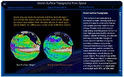 Ocean Surface Topography
(Flash required to view this module.
Download Flash)
Earth's oceans are the greatest influence on global climate. Only from space can we
observe our vast oceans on a global scale and monitor critical changes in ocean currents
and heat storage. Continuous data from satellites like TOPEX/Poseidon and Jason help us
understand and foresee the effects of the changing oceans on our climate and on
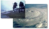
catastrophic climate events such as El Niño and La Niña. View this
interactive Flash module about Ocean Surface Topography to understand the important role
the oceans play in our daily lives. This wonderful new tool was developed by NASA Oceanography.
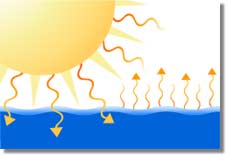
 Our home, the Earth, experiences some of the most varied and interesting weather
in the Solar System. This is because the Earth is actually a water-world, with
some 70% of its surface covered by a vast, deep ocean. The world-ocean is a huge
sink for solar energy. Through currents the ocean transports this energy as heat,
and releases it back into the atmosphere as water vapor, which is then returned back to the
oceans and land as rain or snow. This completes the hydrologic cycle.
Our home, the Earth, experiences some of the most varied and interesting weather
in the Solar System. This is because the Earth is actually a water-world, with
some 70% of its surface covered by a vast, deep ocean. The world-ocean is a huge
sink for solar energy. Through currents the ocean transports this energy as heat,
and releases it back into the atmosphere as water vapor, which is then returned back to the
oceans and land as rain or snow. This completes the hydrologic cycle.
 How can we measure and track changes in the oceanic heat-budget? We need
to know both ocean currents and heat storage of the ocean. Like winds blow
around the highs and lows of atmospheric pressure, ocean currents flow
around highs and lows of oceanic pressure that can be determined from the
height of sea surface, called ocean surface topography. Ocean current
velocity can thus be computed from the slope of the ocean surface.
Furthermore, as water heats up, it expands, and as it cools, it contracts,
affecting the height of sea surface as well. Measuring the ocean surface
topography thus gives the required information for studying global
ocean circulation and the oceans heat budget. Regular scanning of the ocean surface to
maintain a database of ocean surface topography can help predict short-term
changes in weather and longer-term patterns of climate.
How can we measure and track changes in the oceanic heat-budget? We need
to know both ocean currents and heat storage of the ocean. Like winds blow
around the highs and lows of atmospheric pressure, ocean currents flow
around highs and lows of oceanic pressure that can be determined from the
height of sea surface, called ocean surface topography. Ocean current
velocity can thus be computed from the slope of the ocean surface.
Furthermore, as water heats up, it expands, and as it cools, it contracts,
affecting the height of sea surface as well. Measuring the ocean surface
topography thus gives the required information for studying global
ocean circulation and the oceans heat budget. Regular scanning of the ocean surface to
maintain a database of ocean surface topography can help predict short-term
changes in weather and longer-term patterns of climate.
|