Examples for PNS/Service Change Notice 06-06
Tropical Cyclone Probabilistic Surface Wind Speed Text
(Operational Effective May 15, 2006)
Click image above for full product example.
List of Cities by Basin: Atlantic – Eastern Pacific –
Central Pacific – Western Pacific
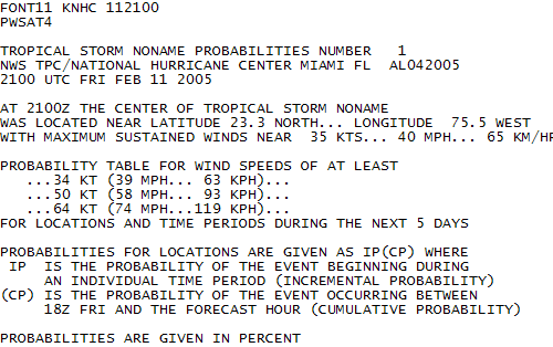
These products provide probabilities of surface wind speeds of at least 34 kt (39 mph, tropical storm force),
50 kt (58 mph), and 64 kt (74 mph, hurricane force) at several locations along the coastlines of the United States
and other countries in the Atlantic and eastern North Pacific basins. The probabilities are based on
errors during recent years in the official track and intensity
forecasts issued by the NHC. Variability in tropical cyclone size
(wind radii) is also incorporated. The NHC issues one separate text product with each advisory package for
each active tropical cyclone in the Atlantic and eastern Pacific basins. Each individual text product contains
probabilities for all three wind speed thresholds.
Tropical Cyclone Probabilistic Surface Wind Speed Graphic
(Operational Effective May 15, 2006)
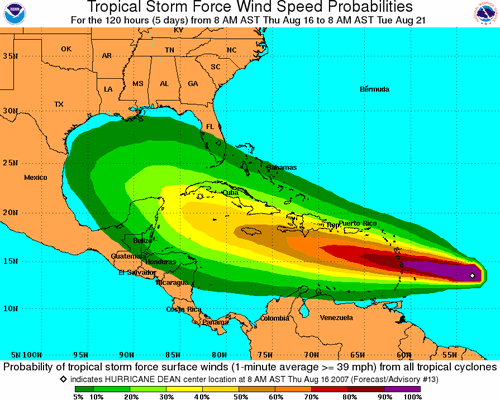
Each wind speed probability graphic provides probabilities (in percent) that wind speeds of at least 34 kt
(39 mph, tropical storm force), 50 kt (58 mph), or 64 kt (74 mph, hurricane force) will occur during cumulative
time periods at each specific point on the map. The probabilities are based on
errors during recent years in the official track and intensity
forecasts issued by the NHC. Variability in tropical cyclone size (wind radii) is also incorporated.
The cumulative periods extend into the 5-day forecast period
at 6-hour intervals (that is, 0-6 h, 0-12 h, 0-18 h, ... , 0-120 h). An individual graphic is produced for
each active tropical cyclone for each cumulative time period and for each wind speed threshold.
The capability to animate through the periods is also provided. These cumulative probabilities
indicate the overall chances that the indicated wind speed will occur at any specific location on the
map during the period between hour 0 and the forecast hour.
In other words, these cumulative probabilities tell decision-makers the chances that the event will
happen at any point on the map within the time period stated on each graphic.
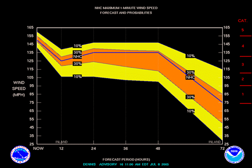
Tropical Cyclone Wind Speed Probability Table
(Operational Effective May 15, 2006)

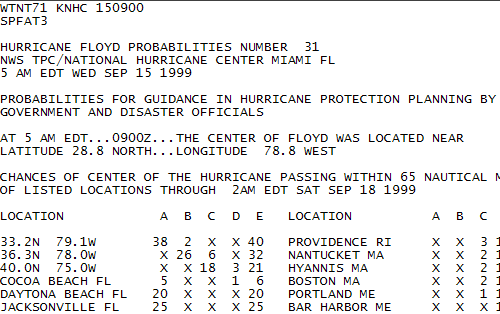
The table shows the probability that
the maximum 1-minute wind speed of the tropical cyclone will be within any
of eight intensity ranges during the next 72 hours. It is based on the
outcomes of similar NHC wind speed forecasts during the period 1988-1997.
The data base excludes unnamed tropical depressions. NA indicates
data not available. TF indicates too few (<10) similar forecasts
during 1988-1997 to yield reliable results.
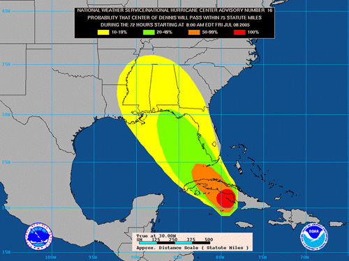
Tropical Cyclone Strike Probability Text
(Discontinued)
Click image above for full product example.
Tropical Cyclone Strike Probability Graphic
(Discontinued)
Tropical Cyclone Wind Speed Forecast and Probability Chart
(Discontinued)
| 


