| Subject Areas |
|
Art and Culture
|
| |
Architecture |
|
History and Social Studies
|
| |
U.S. History - Colonial America and the New Nation |
| |
World History - Europe |
| |
| Time Required |
| | Lesson 1: 1 class period or less
Lesson 2: 1 class period or less
Lesson 3: 1 class period to introduce, more for student research and presentations
Lesson 4: 1 class period
|
| |
| Skills |
| | primary document analysis
critical thinking
presentation/public speaking
collaboration
information gathering
|
| |
| Date Posted |
| | 4/15/2002 |
| |
| Feedback |
| |
Send us your thoughts about this lesson! |
| |
| Email this Lesson |
| |
Send this lesson to friends or colleagues |
| |
|

|
What They Left Behind: Early Multi-National Influences in the United States
Introduction
Beginning with Columbus's first
landing in the New World, European nations laid claim
to what would become the United States. Vestiges of
that history are part of the American landscape. Spanish
missions from Florida to California, the distinctive
architecture of the French Quarter in New Orleans, place
names like New London, Lake Bayou D'Arbonne, Harlem,
Las Cruces....
The lessons in this unit are
designed to help your students make connections between
European voyages of discovery, colonial spheres of influence,
and various aspects of American culture.
Learning Objectives
After completing the lessons
in this unit, students will be able to:
- Map 18th-century Europe's
impact on what is now the United States.
- List remnants of European
influence that remain today.
- Connect marks of European
influence with specific explorers.
Guiding Question: How
did England, France, Holland, Russia, and Spain come
to make claims on territory in North America? What was
the impact of these multi-national influences on the
settlement of North America?
Preparing to Teach this Lesson
- Review each lesson in the
unit. Print out and duplicate and/or bookmark any
images included in the lessons.
- For the purposes of clearly
explaining the activities, the lessons below assume
a class size of 25 students. Adjust the group assignments
as needed to fit your class.
- As background material on
the 1482 map used to introduce Lesson
1, print out and duplicate and/or bookmark the
information about the World
Map (In [Donnus Nicolaus Germanus] Cosmographia,
Claudius Ptolemaeus Ulm, 1482. Thacher Collection,
Rare Book and Special Collections Division), found
on the Library
of Congress website, a link from the EDSITEment
resource American
Memory. The entry is located about three-quarters
of the way down the page and is the second to the
last entry.
- To create the outline map
of European territories in the New World for Lessons
2 and 3,
use European
Territories in the New World from Encarta,
a link from the EDSITEment resource The
Internet Public Library. Outline maps of the U.S.
are also available from the EDSITEment-reviewed website
National
Geographic Society Xpeditions.
Draw in the outlines of the European territories.
The Netherlands' territory includes Manhattan. Though
this area is small, it is significant; if necessary,
mark the area solid black to increase its visibility.
Make five copies of the map.
Cut apart the territories to create a kind of jigsaw
puzzle and place the pieces in an envelope. If possible,
include Alaska and attach it to Russia's claims in the
northeastern United States.
To make the lesson more dramatic,
hang another large map on a bulletin board in class.
Do not mark off the territories or cut the map. When
each group makes its presentation, the students can
attach their territories to the blank map. In this way,
America will be put back together in your classroom!
Suggested ActivitiesLesson 1: What's
Wrong with This Picture? A Map of the World
Lesson 2: America
Divided
Lesson 3: Multi-National
Influences
Lesson 4: Picturing
the Events
Extending the
Lesson
Lesson 1 What's Wrong with This Picture?
A Map of the World
Share with the class the 1482
World Map from 1492:
An Ongoing Voyage, a link from the EDSITEment-reviewed
website American
Memory. Compare the map to a contemporary world
map. Ask the students to list elements that are "wrong
with this picture" in comparing the 1482 map to a contemporary
map. Students should note such points as:
- There is no North or South
America.
- The Indian Ocean is shown
surrounded by land.
Encourage discussion. Does the
1482 map indicate that people knew the world was round?
(Yes, the rounded portions of the map are a result of
the attempt to show a round, three-dimensional object
on a flat map.) Why are there "wind heads?" (They indicate
the dependence on the wind for travel.) What makes the
date of this map significant? (Columbus's first voyage,
only ten years later, would change the map of the world
forever.)
Lesson 2 America Divided
As a result of Columbus' voyage,
Spain made the first claims to the New World, but other
countries soon made claims of their own as a result
of the voyages of their explorers. By the 18th century,
North America had been divided on the basis of these
various claims.
Divide the class into five groups.
Give each group an envelope containing the "jigsaw puzzle"
map of the U.S., showing the territorial claims of England,
France, Holland, Russia, and Spain in the 18th century.
Have the groups remove the puzzle
pieces from the envelope and put together the America
of the 18th century. Tell the students that it would
have been accurate in the 18th century to think of America
not as one country but as separate territories controlled
by European powers, as indicated by the puzzle pieces.
Do the students know why those powers were in control?
Have the groups mix up the pieces
and put the puzzle back together at least once more.
Lesson 3 Multi-National Influences
European claims in the New World
were based on the exploits of a variety of explorers.
The temporary ownership of America by various European
powers—specifically, England, France, Holland,
Russia, and Spain—has left an enduring influence
in America as witnessed through architecture, place
names, music and other cultural touchstones.
Continuing from the activity
in Lesson 2,
have group members take one piece of the puzzle and
form new groups with other students holding the same
piece. (If the teacher wants to form the groups, each
puzzle piece could have a number on the back. The teacher
can pre-assign a specific number to each individual.)
Each group then uses the maps,
images and media listed below to explain to the class
what influence their assigned European nation had—or
continues to have—on the U.S. Groups will complete
research either in the library or online and make a
presentation based on their findings.
Each group should begin its presentation
by attaching its enlarged puzzle piece to the large
outline map on the bulletin board (as explained in Preparing
to Teach This Unit, above), so that the United States
is gradually put back together again.
Groups can divide the labor by
subject:
- Geography: What are
the present-day boundaries of states in the former
European territory?
- History, part 1: Tell
about the explorer.
- History, part 2: Explain
how the territory became part of the U.S.
- Archives: Discuss
the images provided to the group. Show the country's
influence.
- Music: Discuss the
songs/music provided to the group.
Or, groups could divide the labor
by skill, for example:
- Researcher(s)
- Writer(s)
- Artist(s)
- Presenter(s)
If groups are divided by skill,
a student "specialist" (or specialists) is primarily
responsible for that area but depends on group members
for assistance as needed. Researchers should not do
all the research, but rather manage that phase of the
work. Under any circumstances, the group should cover
all subject areas listed above—geography, history
(parts 1 and 2), archives, and music.
Instruct each group to regard
the assigned images as pieces of a puzzle. How do they
fit together to tell the story of the European territory
in the United States?
English Influences
- Explorer's Voyage:
Review Cabot's
Voyages, available through Discoverers
Web, a link from the EDSITEment-reviewed website
Columbus
and the Age of Discovery.
- Architecture: Compare
The
Four Courts, Dublin Ireland, available via Britannica.com,
a link from the EDSITEment resource The
Internet Public Library, to The
Rotunda of the University of Virginia, Designed by
Thomas Jefferson, accessible through a link from
the EDSITEment resource Center
for the Liberal Arts. NOTE: For the University
of Virginia photo, move to the photograph at the top
of the page.
- Song Lyrics: Access the lyrics to the song "Sir William and Lady Margaret" by searching for the title on the EDSITEment resource American Memory. Is it an American song?
- Image: Why is an Englishman laying the corner stone of a new building at Dartmouth College in 1904? Find out by reading the story Go Big Green, available through a link from the EDSITEment resource American Memory.
- Place Name: New York. Why New? What's the origin of the name?
French Influences
Influences from Holland
- Explorer's Voyage:
Review Hudson,
Map of Third Voyage, available through Discoverers
Web, a link from the EDSITEment resource Columbus
and the Age of Discovery. In the frame to the
left, select "Third Voyage: Map."
- Images: Find the following
posters, depicting events that took place from 1656
to 1658, on the EDSITEment resource American
Memory (each image can be found by searching by
title):
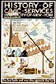
- History of civic services
in the city of New York: Water supply No. 1: The
first public well was dug opposite the fort.
- History of civic services
in the city of New York: Fire Department No. 1:
Fire department founded by Petrus Stuyvesant.
- History of civic services
in the city of New York: Police No. 1: The rattle
watch.
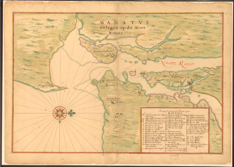
- Additional Maps: Review
the following maps available on the Library
of Congress website, a link from the EDSITEment
resource American
Memory:
- Manatus
gelegen op de Noot Rivier, 1639 Johannes Vingboons's
manuscript map on vellum in pen and ink and watercolor
wash. (Background
information)
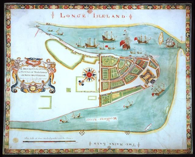
- Description
of the Towne of Mannados or New Amsterdam as it
was in September 1661, 1664 This map was created
with writing in English, less than three years
after a map written in Dutch. Why do students
think this happened? (The English had taken over
the territory.) The following background information
is provided by the Library of Congress:
This map of New York City was presented to James,
Duke of York (1633-1701), the future James II,
shortly after the English captured New Amsterdam
from the Dutch in 1664. Probably copied from a
map made for Dutch authorities in 1661 by Jacques
Cortelyou, the map shows the town walls from which
the name "Wall Street" is derived as well as the
Battery.
- Sinter Klaas Song:
Read the lyrics to this traditional song from the
Netherlands (For background information on Sinter
Klaas, visit Encarta
and Christmas.com,
two links from the EDSITEment resource The
Internet Public Library.):
| Hoor De Wind Waait Door de
Bomen / |
Listen How the Wind Blows
Through the Trees |
| |
| Hoor de wind waait door de
bomen |
Listen how the wind blows
through the trees |
| hier in huis daar waait de
wind. |
even here in the house the
wind is blowing |
| Zou de goede Sint wel komen, |
You think Santa Claus is still
coming |
| nu hij het weer zo lelijk
vindt? |
since the weather is so nasty? |
| Nu hij het weer zo lelijk
vindt. |
Since the weather is so nasty. |
| Als hij komt in donkere nachten, |
He travels in dark nights, |
| op zijn paardje o zo snel. |
on his horsey, oh so fast. |
| Als hij wist hoe zeer wij
wachten, |
If he knew how much we long
to see him, |
| ja gewis dan kwam hij wel, |
then for sure he will come, |
| ja gewis dan kwam hij wel. |
then
for sure he will come. |
- Place Name:
Harlem (also spelled Haarlem). What is the origin of this name?
Russian Influences
- Explorer's Voyage:
Review a Map of Bering's 2nd Expedition, available via Discoverers Web, a link from the EDSITEment resource Columbus and the Age of Discovery.
- Images:
Compare the following photographs:
- "Signal Corps Photographic Unit with American Expeditionary Forces North Russia. Lieutenant Charles I. Reid at the left; Master Signal Electrician Grier M. Shotwell at the right. In the background is the Monastery Church of Archangel" can be accessed by searching for the exact title in the digital copies section of NAIL on the EDSITEment-reviewed website The Digital Classroom. Note the building in the background.
- Photograph. St. Michael's Cathedral, Novoarkhangelsk [Sitka], ca. 1895. Geographic File, Alaska, Prints and Photographs Division (19), available from The Library of Congress, a link from the EDSITEment resource American Memory. Note the building highlighted by the sunlight.
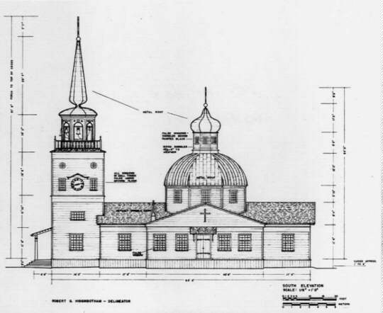
- Silkscreen image from a photostat of a measured drawing, silhouetted. South elevation, St. Michael's Cathedral, Sitka (Novoarkhangelsk), Alaska. HABS Collection, Prints and Photographs Division (23), available from The Library of Congress, a link from American Memory.
- History and Images:
Read about the Purchase of Alaska: March 30, 1867, available through a link from the EDSITEment resource American Memory.
- Audio:
Obtain information about and link to a recording of Russian promyshlenniki's song from Alaska (right-hand side of the page), available on The Library of Congress, a link from the EDSITEment resource American Memory.
- Place Name:
Baranof Island (also spelled Baranov). After whom is the island named?
Spanish Influences
Lesson 4 Picturing the Events
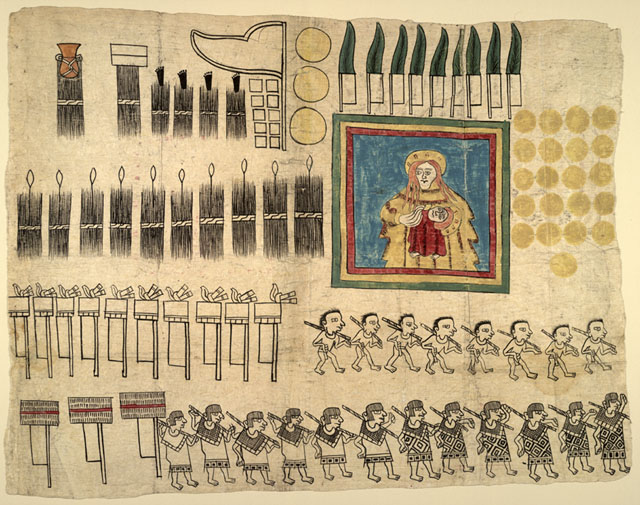
Native Americans were greatly affected by the arrival of Europeans in the New World. In the Codex, available through a link from the EDSITEment resource American Memory, the people of Huejotzingo told the story of their encounter with the Spanish. Background information about the Codex is also available through a link from American Memory. See the fourth segment on the page, titled "Testimony from Huejotzingo."
Share one or more pages from the Huejotzingo Codex with the class. The first page illustrates the products and services provided as tribute to the Spanish. Judging from the Codex, what were these products and services?
Challenge the students to use images, as the people of Huejotzingo did, to illustrate the information previously presented by the groups (England, France, Holland, Russia, Spain). Using pictures as much as possible, students should be sure to:
- Identify the territory claimed by the European country.
- Illustrate the influence of the Europeans in the U.S., such as in architecture.
- Provide information about an explorer from the European country.
Extending the Lesson
- Students interested in learning about other explorers should check out Discoverers Web, a link from the EDSITEment resource Columbus and the Age of Discovery, for an alphabetical listing of explorers and many useful related links.
- The EDSITEment unit On This Day with Lewis and Clark discusses the Louisiana Purchase, a major step in "putting America together again." The EDSITEment unit What Was Columbus Thinking? discusses the effects of European exploration on Native Americans and, to a lesser degree, the effect of Native American culture on the Europeans.
- Sprocket Works, a link from the EDSITEment-reviewed website The Internet Public Library, features an interactive timemap showing the U.S. borders at various points in history.
- Students can research place names in their own state that appear to be from a language other than English. Students also can research place names beginning with "New." Where is the "old" place?
Selected EDSITEment Websites
-
American Association of Teachers of French
http://aatf.utsa.edu/
-
Paris.org
http://www.paris.org/
-
American Memory Project, Library of Congress
http://memory.loc.gov/
-
The Library of Congress
http://www.loc.gov
-
-
1492: An Ongoing Voyage
http://lcweb.loc.gov/exhibits/1492/intro.html
-
America's Library
http://www.americaslibrary.gov
-
Center for the Liberal Arts
http://www.virginia.edu/cla/
-
Columbus and the Age of Discovery
http://muweb.millersville.edu/~columbus/
-
Discoverers Web
http://www.win.tue.nl/~engels/discovery/
-
-
The Virtual Museum of New-France
http://www.civilization.ca/vmnf/vmnfe.asp
-
Digital Classroom
http://www.nara.gov/education/
-
The Internet Public Library
http://www.ipl.org
-
AltaVista Translation Service
http://babelfish.altavista.digital.com/
-
National Geographic Society Xpeditions
http://www.nationalgeographic.com/xpeditions/
-
Map Machine
http://plasma.nationalgeographic.com/mapmachine/
-
River of Song
http://www.pbs.org/riverofsong/
Other Resources
Recommended reading from The Library of Congress, a link from American Memory
- Winchester, Faith. Hispanic Holidays. Mankato, MN: Bridgestone Books, 1996.
Recommended readings from Carol Hurst's Children's Literature Site, a link from The Internet Public Library
- Costabel, Eva Deutsch. The Jews of New Amsterdam. Atheneum, 1988. ISBN: 0-689-31351-9. Grades 2+
- Fradin, Dennis. The Thirteen Colonies (series). Children's Press, 1990. ISBN: 0516003852. Grades 2+
- Fritz, Jean. The Double Life of Pocahontas. Putnam, 1983. ISBN 0-399-21016-4. Grades 3+
- Lobel, Arnold. On the Day Peter Stuyvesant Sailed into Town. Harper, 1971. ISBN 0-06-443144-4. Grades 1+
- McGovern, Ann. If You Sailed on the Mayflower in 1620. Illustrated by Anna DiVito. Scholastic, 1991. ISBN 0-590-45161-8. Grades 2+
- Sewall, Marcia. People of the Breaking Day. Atheneum, 1990. ISBN 0-689-31407-8. Grades 2+
- Sewell, Marcia. Pilgrims of Plimouth. Macmillan, 1986. ISBN 0-689-31250-4. Grades 2+
- Sewall, Marcia. Thunder From the Clear Sky. Atheneum, 1995. ISBN 0-689-31775-1. Grades 2+
Recommended reading from The Reading Corner, a link from The Internet Public Library
- Fritz, Jean, Katherine Patterson, Patricia and Frederick McKissack, Margaret Mahy, and Jamake Highwater. The World in 1492. New York: Holt, 1992.
Standards Alignment
View your state’s standards
|


![Photograph. St. Michael's Cathedral, Novoarkhangelsk [Sitka], ca. 1895. Geographic File, Alaska, Prints and Photographs Division (19)](https://webarchive.library.unt.edu/eot2008/20090117052804/http://lcweb.loc.gov/exhibits/russian/mtns.jpg)