
 Feeds & Data
Magnitude 7.7 - ANTOFAGASTA, CHILE
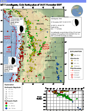
2007 November 14 15:40:50 UTC
Earthquake Details
| Magnitude | 7.7 |
|---|---|
| Date-Time |
|
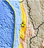
| Location | 22.204°S, 69.869°W |
| Depth | 40 km (24.9 miles) set by location program |
| Region | ANTOFAGASTA, CHILE |
| Distances | 35 km (25 miles) ESE of Tocopilla, Chile 100 km (65 miles) WNW of Calama, Chile 165 km (105 miles) NNE of Antofagasta, Chile 1245 km (770 miles) N of SANTIAGO, Chile |
| Location Uncertainty | horizontal +/- 6.1 km (3.8 miles); depth fixed by location program |
| Parameters | NST=323, Nph=323, Dmin=108.4 km, Rmss=1.09 sec, Gp= 40°, M-type=moment magnitude (Mw), Version=V |
| Source |
|
| Event ID | us2007jsat |
- This event has been reviewed by a seismologist.
- Did you feel it? Report shaking and damage at your location. You can also view a map displaying accumulated data from your report and others.
Earthquake Summary

The following is a release by the United States Geological Survey, National Earthquake Information Center: An earthquake occurred about 40 km (25 mi) east-southeast of Tocopilla at 8:40 AM MST, Nov 14, 2007 (12:40 PM local time in Chile). The magnitude and location may be revised when additional data and further analysis results are available.
Felt Reports
Two people killed, at least 45 injured and buildings damaged (VIII) at Tocopilla. Twenty people injured and buildings damaged (VII) at Maria Elena. Several thousand homes destroyed or damaged, displacing about 15,000 people in the Maria Elena-Tocopilla area. Buildings damaged (VII) at Antofagasta and Calama. Power and telephone outages occurred at Antofagasta and Iquique. Felt (VIII) at Quillagua; (VII) at Baquedano and Mejillones; (VI) at Alto Hospicio, Arica, Huara, Iquique and Taltal; (V) at Caldera, Chanaral, Copiapo and Tierra Amarilla; (III) at Alto del Carmen, Coquimbo, Freirina, Huasco, La Higuera, La Serena and Vallenar; (II) at Santiago, Valparaiso and Vina del Mar. Felt from Arica to Santiago. Felt (IV) at Arequipa; felt at Lima and in Moquegua and Tacna, Peru. Felt (III) at La Paz; felt at Cochabamba and in other parts of Bolivia. Felt at San Juan, Argentina. Also felt at Sao Paulo, Brazil. Tsunami wave heights in centimeters (peak-to-trough) were recorded at the following tide stations: 25.5 at Antofagasta, 19.5 at Arica, 9.5 at Caldera and 19.3 at Iquique.
Tectonic Summary
The earthquake near Antofagasta, Chile of November 14th 2007 results from the release of stresses generated by the subduction of the oceanic Nazca plate beneath the South American plate. In this region, known as the Peru-Chile subduction zone, the Nazca Plate thrusts beneath South America at a rate of approximately 79mm/year in an east-north-east direction. This earthquake indicates subduction-related thrusting, likely on the interface between these two plates.
This earthquake occurred near (and within) the southern end of the rupture area of the great magnitude 8.8 earthquake of 1877, which produced a destructive tsunami and whose source region has since the late 1970’s been recognized as a potentially dangerous seismic gap. In 1995, a magnitude 8.0 earthquake thrust-fault occurred in the same subduction zone approximately 200km further south of the November 14th event.
Earthquake Information for South America
Earthquake Information for Chile
 Tsunami Information
- NOAA West Coast & Alaska Tsunami Warning Center
- NOAA Pacific Tsunami Warning Center
- Tsunami Information Links
The earthquake locations and magnitudes cited in these NOAA tsunami bulletins are very preliminary and may be superceded by USGS locations and magnitudes computed using more extensive data sets.
Earthquake Maps


Scientific & Technical Information

- Preliminary Earthquake Report
- U.S. Geological Survey, National Earthquake Information Center:
World Data Center for Seismology, Denver
