 


|
|
|
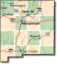
Whenever you plan to head out on to your public lands, it's always wise to call ahead to the Field Office or Ranger Station that oversees your destination to check on local conditions. Point and click at the interactive map above to search all of the state's recreation sites for phone numbers and other details. |
New Mexico Fire News
LATEST FIRE NEWS
NEW MEXICO RESTRICTIONS AND CLOSURES
SEEING SMOKE IN NEW MEXICO? MAYBE IT'S INTENTIONAL
Show all Agency releases for New Mexico
PRESS SECTION -- click here to read official agency Press Releases and/or Restriction and Closure Orders
Latest Fire News
|

Prescribed burns like this one help reduce fire danger, and so do following posted restrictions! Keep our public lands open this summer!
|
LATEST FIRE NEWS
After Labor Day, 2008
Opportunities for outdoor fun on public lands abound year round - even during the spring and summer "fire season." There is always some place where you can camp, hike, fish, visit historic sites or take a leisurely drive to enjoy the scenery.
Land management agencies, tribal governments, counties and cities pay particularly close attention to fire prevention and preparedness every year - regardless of moisture - to ensure that your outdoor experiences will be pleasant and safe.
YOUR bottom line? Always plan outdoor excursions wisely, call local authorities to check on any last-minute changes in conditions before you leave and BE CAREFUL OUT THERE! Remember, FIREWORKS are ALWAYS illegal on public lands!!
|
|

Grill at Big Arsenic campground.

Outdoor fun on the Rio Grande.
|
NEW MEXICO RESTRICTIONS AND CLOSURES
WHAT`S OPEN:
Most EVERYTHING!! except for the few areas listed below.
It`s always wise to call ahead to the Field Office or Ranger Station that oversees your destination to check on local conditions. Point-and-click your way around the interactive map of New Mexico above to search all of the state's recreation sites for phone numbers and other details.
WHAT`S RESTRICTED:
Different land managing agencies establish their fire restrictions for their lands in different ways. Some use national forest or ranger district boundaries, county lines or their agency-based administrative areas. Use the maps found throughout this website to clarify where you might be restricted from using fires. Start here to find county or national forest boundaries.
NATIONAL FORESTS and GRASSLANDS
NONE OF THE NATIONAL FORESTS IN NEW MEXICO ARE CURRENTLY OBSERVING ANY FIRE RESTRICTIONS.
NATIONAL PARKS AND MONUMENTS
NONE OF THE NATIONAL PARKS AND MONUMENTS IN NEW MEXICO ARE CURRENTLY OBSERVING ANY SEASONAL FIRE RESTRICTIONS.
However, individual National Parks and Monuments maintain differing restrictions on cooking and campfires year round - use the interactive map above to locate individual sites and check the NOTES at the bottom of a site's page for local restrictions.
BUREAU OF LAND MANAGEMENT (BLM)
NONE OF THE BLM FIELD OFFICES IN NEW MEXICO ARE CURRENTLY OBSERVING ANY FIRE RESTRICTIONS.
For a map of BLM Field Office boundaries in New Mexico, click here.
U. S. ARMY CORPS OF ENGINEERS Reservoirs
NEITHER OF THE ARMY CORPS LAKES IN NEW MEXICO ARE CURRENTLY OBSERVING ANY FIRE RESTRICTIONS.
Corps lakes at Abiquiu and Cochiti usually follow the lead of nearby national foests. Conchas Lake coordinates any restriction it might impose with the Conchas Lake State Park.
VALLES CALDERA NATIONAL PRESERVE
The unique Preserve west of Los Alamos maintains Level One restrictions year-round.
STATE PARKS and STATE LANDS
NONE OF THE STATE TRUST LANDS AND STATE PARKS IN NEW MEXICO ARE CURRENTLY OBSERVING ANY FIRE RESTRICTIONS.
BUREAU of INDIAN AFFAIRS (BIA)
The Navajo Reservation in Arizona and New Mexico entered restrictions on May 1st. They are allowing recreational campfires ONLY in developed recreation areas.
The Zuni Pueblo entered restrictions on May 11th. For details, call the Pueblo at (505)782-7238.
Stage I restrictions went into effect April 24th for the Pueblos of Acoma, Cochiti, Isleta, Jemez, Sandia, San Felipe, Santa Ana, Santo Domingo, and Zia. To read the official news release, click here.
The Mescalero Apache Reservation is also observing restrictions on open fires. Travel throughout the reservation is being restricted (no stopping or parking along roadway), including on US Highway 70 and State Road 244. Smoking is only allowed indoors and in vehicles. Other restriction apply primarily to residents of the reservation and contractors, but if you intend to visit the Mescalero Reservation, call toll free 888-324-0348 for details. To read the official order, click here.
Although Native American tribal governments cooperate in federal and state fire prevention plans and activities, one should always
remember that tribal lands are NOT public lands; please observe all tribal restrictions on access, photography, etc.
WHAT`S CLOSED:
Local conditions sometimes require land managers to close access or use of areas within their jurisdiction. ALWAYS check with local offices before venturing out on to New Mexico's public lands.
It's flood, not fire that has caused late July closure of a portion of the Lincoln National Forest near Ruidoso. (Read the official Press release by clicking here). SOME OF THESE AREAS RE-OPENED AUGUST 8th. TO READ THAT PRESS RELEASE, CLICK HERE.
The Cibola National Forest's MOUNTAINAIR RANGER DISTRICT re-opened Red Canyon and Fourth Of July Campgrounds July 11th. Please note the trail from Red Canyon Campground to the Crest Trail is now open BUT trails to the south and along the crest in the Ojo Fire area are closed. For details, click here or call the Ranger Station in Mountainair at 505-847-2990.
However, there is a newly closed area caused by the Big Spring fire on the Cibola National Forest's MOUNTAINAIR RANGER DISTRICT inside Forest Road 55 near the villages of Torreon and Tajique. Click here to view a map of the closed area or call the Ranger Station in Mountainair at 505-847-2990 for more information.
|
SEEING SMOKE IN NEW MEXICO? MAYBE IT'S INTENTIONAL
Many agencies and tribes practice prescribed burning to eliminate excess fuels and reduce fire danger. Weather and environmental conditions play a key role in the timing and accomplishment of these projects. People in these areas will see and smell smoke for the duration of the burn; smoke inversions may occur during nighttime hours. As always, firefighter and public safety are the top priority. For an example of an agency Press Release announcing a prescribed burn project, click here.
Sometimes, naturally caused wildfires are allowed to burn as "wildland fire use" (WFU)fires for the same reasons. The objective of any WFU fire is to protect, maintain and enhance resources, and, as nearly as possible, allow fire to function in its natural ecological role within defined boundaries.
Before a fire is put into WFU status, land managers evaluate several criteria. For example, archaeologists and wildlife biologists inspect the area to ensure wildlife habitats and archaeological sites will not be harmed as a result of the fire or management practices. Once a fire is put into WFU status, it is actively managed, meaning boundaries, weather and fuels conditions under which the fire will be allowed to burn are established. For an example of a Press Release for a WFU, click here.
In both cases, agency fire managers follow strict guidelines, monitoring burn conditions and the generation of smoke. If you are concerned about how wildfire smoke can affect your health, click here.
|
|

Fire managers use prescribed fire as a tool to reduce the risk of wildfire.
|
Fire Restriction Definitions
Remember, FIREWORKS are ALWAYS illegal on public lands!!
Agency and tribal Fire Restrictions and Closures apply to undeveloped lands as well as to their developed recreation sites. Some agencies do not use levels or stages of restrictions; they either are or are not in restrictions as posted above.
To view official Agency Press Releases and Restriction or Closure Orders in detail, click here.
Stage ONE Restrictions:
Open campfires, charcoal grills and stove fires are prohibited, except in developed camp and picnic grounds where agency-built fire rings or grills are provided - these are usually areas that charge campsite fees. Sometimes, getting a campfire permit from the Ranger in developed campgrounds is also required. Check postings at the campground before starting your fire.
Pressurized liquid or gas stoves, lanterns and heaters usually are allowed. Again, check local postings to be sure.
Smoking is restricted to enclosed buildings, within vehicles equipped with ashtrays and on paved or surfaced roads, within developed recreation sites or while stopped in an area at least three feet in diameter that is barren or cleared of all flammable material.
Open burning, i.e., burning of cropland, fields, rangeland, debris burning, slash piles, or weed burning, is prohibited. At this level of fire restrictions, fire managers may use prescribed fire as a tool to reduce the risk of unwanted wildfire.
Stage TWO Restrictions:
NO OPEN FIRES!!! Which means that "building, maintaining, attending or using a fire, campfire, charcoal, broiler, coal, or wood stove fire is prohibited" anywhere in the restricted jurisdiction- even in developed recreation sites. Public lands users are allowed to use pressurized liquid or gas stoves, lanterns, or space-heating devices - check your gear before heading out to be sure it operates safely.
Smoking is only allowed inside an enclosed vehicle.
NO motor vehicles can be taken off road, except when parking in an area devoid of vegetation within 10 feet of the roadway.
Parking overnight in developed campgrounds and trailheads is usually allowed.
Internal or external combustion engines must have properly installed, maintained, and working spark arrestors.
Explosives (including fireworks) are prohibited.
Operating chainsaws, other equipment powered by an internal
combustion engines, and welding is usually restricted as well.
Stage THREE Restrictions authorize partial closure of affected areas.
Stage FOUR Restrictions call for total closure of affected areas.
|
|
|


)
)
)
)