New Mexico Water Science Center
DATA CENTER
USGS IN YOUR STATEUSGS Water Science Centers are located in each state. 
|
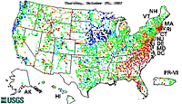
WaterWatch—Current Water Resources ConditionsWaterWatch is a U.S. Geological Survey (USGS) World Wide Web site that displays maps, graphs, and tables describing real-time, recent, and past streamflow conditions for the United States. The real-time information generally is updated on an hourly basis. WaterWatch provides streamgage-based maps that:
Current streamflow conditionsReal-time streamflow conditions: Map · Summary plot · Percent plot · Summary table · Map animation · Streamflow table · Google Earth KML Flood and high flow: Map · Locations above flood stage · Map animation Daily streamflow condition for day of year: Map · Summary plot · Percent plot · Summary table · Drainage basin (HUC) map Daily steamflow condition for all days of year: Map · Summary plot · Percent plot · Summary table · Drainage basin (HUC) map 7-day average streamflow conditions for day of year Map · Summary plot · Percent plot · Summary table · Drainage basin (HUC) map 7-day average streamflow conditions for all days of year Map · Summary plot · Percent plot · Summary table · Drainage basin (HUC) map 14-day average streamflow conditions for day of year Map · Drainage basin (HUC) map 28-day average streamflow conditions for day of year Map · Drainage basin (HUC) map FloodWatchMap of flood and high flow locations DroughtWatch7-day below normal streamflow for day of year Map · Summary plot · Drainage basin (HUC) map 7-day below normal streamflow for all days of year Map · Summary plot · Drainage basin (HUC) map 14-day below normal streamflow for day of year Map · Drainage basin (HUC) map 28-day below normal streamflow for day of year Map · Drainage basin (HUC) map Recent and Historical StreamFlowMaps of recent 1-day, 7-day, 14-day, and 28-day average streamflow Maps of recent monthly average streamflow Maps of historical annual and monthly runoff for hydrologic units Time-series plots of historical annual runoff for hydrologic units Annual Streamflow Summaries |

![]() U.S. Department of the Interior |
U.S. Geological Survey
U.S. Department of the Interior |
U.S. Geological Survey
URL: http://nm.water.usgs.gov/infodata/waterwatch.html
Page Contact Information: webmaster@nm.water.usgs.gov
Page Last Modified: Monday, 10-Dec-2007 08:06:21 EST
