Ground-Water Watch


New Mexico Climate Response Network
Hover mouse over site for information.
Click site to open page with county information and site selection.

NEW MEXICO 1. Site: 322323106314701


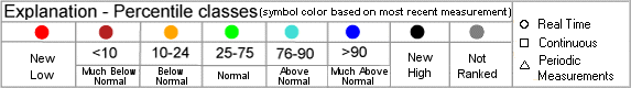
Map Created 1/15/2009 8:58:56 AM
Ground-Water Watch
Help Page
    Download Google
Earth Version
    Display
interactive map

New Mexico Climate Response Network wells depicted on the state location map
As of 1/15/2009 9:57:16 AM
Note: Color shading in the table below indicates multiple wells that plot as a single point on the state location map above.
Note: BLS = Water Level in Feet Below Land Surface, AVD = Water Level in Feet Above Vertical Datum
Map
Index
Site ID Site NameMost Recent
Measurement
DateWell
Depth
Local Aquifer
1 322323106314701 22S.04E.15.331 BLM WELL59.33 BLS 10/6/2008  295.0   Bolson Fill


AccessibilityFOIAPrivacyPolicies and Notices

Take Pride in America logoUSA.gov logoU.S. Department of the Interior |U.S. Geological Survey
URL: http://groundwaterwatch.usgs.gov/StateMapsNet.asp
Page Contact Information: OGW Webmaster
Last update: Wednesday, October 15, 2008 at 13:09