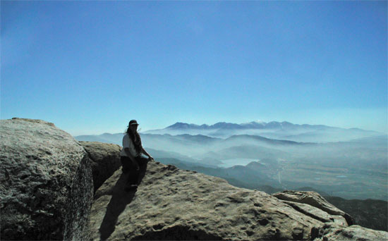
San Bernardino National Forest
San Bernardino
National Forest 909-382-2600 |
|
|
|
Hiking, Trails & Trailheads
|
|||||||||||||||||||||||||||||||||||||||||||||||||||||||||||||||||||||||||||||||||||||||||||||||||||||||||||||||||||||||||||||||||||||||||||||||||||||||||||||||||||||||||||||||||||||
| Pacific Crest
Trail - (160 miles and crosses all three Ranger Districts on the San Bernardino National Forest) The
Pacific Crest Trail (PCT) is the jewel in the crown of
America’s scenic trails, spanning 2,650 miles from Mexico to
Canada through three western states. It reveals the beauty
of the desert, unfolds the glaciated expanses of the Sierra
Nevada, and provides commanding vistas of volcanic peaks and
glaciers in the Cascade Range. The trail also passes through
historic mining sites and evidence of human’s endless quest
for natural resources. Thousands of hikers and equestrians
enjoy this national treasure each year. Some only travel a
few miles, while others complete every mile in a single season! The history of the Pacific Crest Trail started when the route was first explored in the late 1930s by teams of young men from the YMCA. Once proven feasible, trail pioneers Clinton Clarke and Warren Rogers lobbied the federal government to secure a border-to-border trail corridor. They had to settle, however, for several disconnected trails along the crest of each state. Largely through the efforts of hikers and equestrians, the PCT was eventually designated one of the first scenic trails in the National Trails System authorized by Congress in 1968, and was dedicated in 1993.
|
Cajon
|
Name |
Amenities and Activities |
| Cucamonga Peak 7W04 - The most accessible trailhead for hiking Cucamonga Peak is Icehouse Canyon (near Mount Baldy) Forest Service Trail 7W07 leads from here to Icehouse Saddle, from which the Cucamonga Peak Trail (7W04) leads to the summit. This route is 12 miles (19.3 km) round trip, with 4,300 feet (1,300 m) of elevation gain. |
|
| Cucamonga Canyon 7W05 - (2.3 miles, moderately difficult) Beginning elevation 2960 feet. This trail begins on Forest Road 1N35 approximately 1 1/2 miles west of the junction of Forest Road 1N35 and 1N34, north of the community of Rancho Cucamonga. The trail winds its way up Cucamonga Canyon through thick chaparral by a number of climbing turns which gradually gain in elevation. At the highest point on the trail you can look north and some distance away you will see Cucamonga Falls. The trail then descends with several switchbacks leading to the rocky streambed at the end of the trail. |
|
| Mormon Rocks Interpretive 6W04 - (1.0 mile, easy walk) Beginning elevation is 3360 feet. This trail was built by the Forest Service fire engine crew in 1975 to provide easy access to the many forest visitors wanting a closer look at the unique and historic Mormon Rocks (Rock Candy Mountains). These striking sandstone formations are riddled with small holes and caves; home of the owl, lizard, and pack rat. The trail begins at the Mormon Rocks fire station located on Highway 138 just west of Interstate 15. The historic Mormon Trail of the previous century passed through this valley of geological curiosity. |
|
| Chaparral Neighborhood 6W03 - (.3 mile, easy walk.) Beginning elevation 2720 feet. This trail begins at the Penny Pines plantation at the eastern edge of the Cajon Ranger Station parking lot. it can be easily walked in 15 minutes; you may want to take longer however to enjoy its features and setting. The trail weaves through a pine plantation planted in the 1960's, native chaparral of the canyon floor, and near the Starke Forest planted in 1935. |
|
| Baldy Mesa OHV - Closed due to railroad construction project, this includes OHV staging area at RR trestles. OHV users need to use 3N22 Summit Staging area, south of Highway 138, east of I-15. |
|
Arrowhead
|
Name |
Amenities and Activities |
| Little Green Valley 3W10 - (4.6 miles, difficult) This trail begins on the north side of Highway 18 between the two entrances to Snow Valley Ski area. Little Green Valley Trail climbs steeply to the north until you reach a meadow at Forest Service Road 2N19. This trail provides you with outstanding views of Snow Valley and Slide Peak. The trail ties into 1W26, then to 2N64 which the Forest Service tied into 2N20 and back around behind the Nordic Ski area to make a loop. This trail is mainly used by mountain bikes |
|
| Camp Creek National Recreation Trail 1W09 (2.9 miles) - closed due to lack of maintenance This trail begins .4 miles east of the Main Gate of the Snow Valley Ski Resort at the 2N97 Forest Road turnout. Signage at the trailhead will direct you to the Camp Creek Trail which 2N97 intersects in .3 miles. It is a very steep trail with an elevation change of 2,000 feet. It terminates at Bear Creek. |
|
| Children's Forest Trail of the Phoenix 2W09 - (0.8 mile, easy walk) This paved nature trail begins at the entrance of the National Children's Forest off Keller Peak Road. The trail is specifically designed and maintained to accommodate the needs of the visually and physically disabled. The trail maintains a grade of 5% or less. |
|
| Children's Forest Exploration Trail 2W09X - (4.38 miles) Parking at the bottom and at the top of the trail. Located off of Keller Peak. Road (1N96) in Arrowbear. Also excellent views as you are walking down from the top. Can be used by hikers and mountain bikers, but the bikes need to be careful of the switchbacks and the waterbars that stick up above the trail bed and riders remember, pedestrians have the right of way. |
|
| Seeley Creek / Heart Rock 4W07 - (.49 mile, easy walk) This short trail begins on Forest Service Road 2N03 - 1/4 mile south of the entrance to Camp Seeley on Highway 138. You must cross the creek. This easy hike follows Seeley Creek to an overlook called "Heart Rock" which marks the trail's end. The gentle grade of this trail makes it an excellent walk for all ages. |
|
| Hot Springs / Goat Trail 3W02 - (1.8 miles, difficult, 950 feet drop in elevation) This trail begins on the north edge of the forest near Bowen Ranch (where you are asked to pay a toll to cross private land) and leads south to Deep Creek. Directly south across Deep Creek you will find the Hot Springs pools for which this trail is named. More information is available in the Deep Creek Hot Springs Page. |
|
| Crab Creek / Fisherman's Camp 2W07 - (2.29 miles, moderately difficult) This trail begins 1.3 miles west of Crab Flats Campground on Forest Service Road 3N34; Crab Creek Trail provides the primary access to Fisherman's Camp (a group reservation trail camp) on Deep Creek. The trail descends moderately westward crossing Crab Creek 1.3 miles from Deep Creek. Deep Creek must be forded to reach Fisherman's Camp. Attempting to cross Deep Creek when it is running high can be dangerous. The scenery along this trail is exceptional; Camping at Fisherman's Camp is by group permit only. |
|
| Hawes Peak 2W08/2W14 (west) - (4.5 Miles, moderate) Hawes Peak Trail begins on 2W08, 2/10 miles West of Tent Peg Campground on 3N34. Travel 1.3 miles to Pacific Crest Trail. Follow PCT east 1/4 mile to 2W14, go north 3.3 miles. Trail ends at a yellow post site, on 3N41. No bicycles on the PCT. |
|
| Holcomb Crossing 2W08 (east) - (1.6 miles, moderately difficult) This trail begins 1/2 mile west of Crab Flats Campground on Forest Service Road 3N34, The trail descends rapidly until it intersects the Pacific Crest Trail approximately 1/4 mile west of Holcomb Crossing Trail Camp. This trail will provide you with a variety of forest settings in a relatively short hiking distance. Camping at Holcomb Crossing Trail Camp is available. bicycles are authorized on this trail but not on the PCT. |
|
| Heaps Peak Arboretum Sequoia 3W05 - (0.9 mile, easy walk) This interpretive trail is located 1.4 miles east of Skyforest on Highway 18. The trail is an easy walk for all ages that takes you through a self-guided tour with 24 points of interest about native plants and wildlife. The site was constructed and is maintained by volunteers from the Rim of the World Interpretive Association. |
|
| Splinters Cabin / Pacific Crest Trail - (40 miles moderately difficult) The Pacific Crest Trail extends 2600 miles from Canada to Mexico. Although a few marathon hikers have gone the length in one trip, most take the trail in segments over a period of years. It enters where Forest Service Road 3N16 crosses Holcomb Creek and exits at Boundary Ridge north of Cleghorn Mountain. The trail is for horse and foot traffic only; all motorized vehicles and bicycles are prohibited. Entry and exit points are numerous, which makes the trail ideal for short nature walks, half-day hikes or day hikes. Some highlights of the PC2000 as it winds through the San Bernardino Mountains are: the scenic quality of Holcomb Creek and Deep Creek, the granite gorge called Devil's Hole:, the hot springs, the outstanding views of Silverwood Lake and Little Horsethief Canyon. Overnight camping along Deep Creek is NOT permitted. |
|
| Northshore National Recreation Trail / Little Bear 3W12 -(1.9 miles, moderately difficult) This trail is best reached by starting at the beginning of Forest Service Road 2N25 between North Shore Campground and Papoose Lake. To reach 2N25, turn east on Torrey Road opposite the Lake Arrowhead Marina. Turn at first left and follow the dirt road 112 mile to where you reach the trail head on the east (right) side of 2N25. The trail descends gently through a mixed conifer forest and settles finally along Little Bear Creek where you will reach Forest Service Road 2N26Y after 1 mile. |
|
| Dogwood 3W04 - (1.2 Miles) Located in the Dogwood Campground |
|
| Enchanted Loop 3W18 - ( 0.29 miles) Located in the Dogwood Campground |
|
| Tunnel II 3W19 - ( 0.45 miles, easy trail) closed due to lack of maintenance Tunnel II Trail begins at Forest Service Road 2N34. Take Grass Valley Rd. to Clubhouse. Follow Clubhouse to Fairway, continue on Fairway, turning right on Brentwood. Turn left on Sonoma to 2N34. Go left on 2N34 follow to trailhead This trail enjoys views of Miller Canyon and Lake Silverwood. |
|
| Metate / Rock Camp 3W15 - (0.41 miles, easy walk) This trail begins immediately east of Rock Camp Station on Highway 173. The trail leads to bedrock mortars used by the Serrano Indians to grind acorns and to make flour. The Serrano came to this area each spring because of the plentiful acorn crop and the mild weather. Bedrock mortars were formed by the grinding action of mono and pestle stones. It was much easier to use these large bedrock slabs rather than carry a mortar stone with them, but they also did that in areas where such stones did not exist. A stone monument was placed on the site by the Lake Arrowhead Woman’s Club to designate the historical importance of this encampment to the Serrano Indians. |
|
| Pinnacles 3W16 - (1.8 miles, difficult) Pinnacles Trail Begins at the entrance to the Rifle Range on Highway 173, north of Rock Camp and ends at the top of the peak. From the top, on clear days you can look into Mojave desert. Along the trail there are steel posts and rock cairns to help you find the path as the trail travels over and around large boulders. At the summit there is a book to sign in at the top. |
|
| Pinnacles OHV - OHV Staging area on Highway 173 north of Lake Arrowhead |
|
Big Bear
|
Name |
Amenities and Activities |
| Alpine Pedal Path 1E50 - (3.2 miles long; very easy) The Alpine Pedal Path is an asphalt path that wanders along the north shore of Big Bear Lake. It is easily accessible for hikers, skaters, joggers and even strollers and wheelchairs. It starts at Stanfield Cutoff and ends at the Discovery Center. |
|
| Glory Ridge 1W02 - (0.7 miles) The turnout to the trailhead is 2 miles west of the Big Bear Lake dam on Highway 18, just after the Highway reduces from two lanes to one. Drive down rutted Forest Road 2N15. Turn right at the fork onto a dirt road. Drive slowly and park on a knoll at the road's end. Follow the trail .25 miles to the trailhead which marked by a "Fishermen" sign. Now the trail becomes very strenuous, dropping 1,100 feet in 1 mile. |
|
| Castle Rock 1W03 - (2.4 miles Strenuous) Park at a turnout along Highway 18, 1 mile East of the Big Bear Dam. There is a small sign marking the Castle Rock Trailhead. From here its 1/2 mile of steep well-marked trail then it levels out for another 1/2 mile of less steep trail. Castle Rock is a large 100 ft outcropping from which you will find 360 degree views. |
|
| Champion Lodgepole 1W11 - (.6-mile round trip; easy) The Lodgepole Pine Trail is on the south side of the lake and is a gentle walk down a path along a stream, ending up at the Champion Lodgepole Pine, one of the largest known Lodgepoles in California. Begin by driving up Mill Creek Road (Forest Road 2N10) for 4.5 miles, turn right on 2N11 and continue 1 mile to the trailhead. |
|
| Bluff Mesa 1W16 - (0.37 miles) The Bluff Mesa Trail
starts at the Champion Lodgepole Pine. It goes North .4 miles to the Bluff Mesa Group Camp. |
|
| Pineknot 1E01 - (3.14 Miles) Adjacent to Aspen Glen Picnic area off Mill Creek Road. Oaks, pines, wildflowers, and spectacular views of Big Bear Lake abound along the Pine Knot Trail, which starts at the Aspen Glen Picnic Area and continues in a primarily southerly direction until it approaches Grand View Point (7,784 ft. elev.- located about one-quarter mile beyond the intersection of the Pine Knot Trail and FS Road 2N10). |
|
| Sugarloaf National Recreation Trail 2E18 - From the south end of Stanfield Cutoff on Big Bear Boulevard (Highway 38), continue for 6 miles heading south toward Redlands. Turn right on 2N93 at the intersection of Highway 38 and Hatchery Road. Follow this dirt road until you reach the Sugarloaf Trail sign and park in the turnout. The first 2 miles follows an old, gated closed dirt road, which at times follows Green Creek. Although the view from the summit of Sugarloaf Mountain is mostly obscured by trees, you have climbed to an altitude of 9,952 feet, the highest point in the Big Bear Valley. |
|
| Cactus Flats OHV - Highway 18, north of Big Bear |
|
| Woodland 1E23 - (1.5-mile loop; easy) This is a unique nature trail with 19 posted stops. Pick up a pamphlet at the entrance and take the self-guided tour where you will learn about botany, geology and the wildlife of this dry woodland area. You can leave your car in the parking lot if you exhibit an Adventure Pass. |
|
| Hanna Flat 1W05 - ( 3.9 miles) to Grays Peak. closed due to Butler 2 Fire |
|
| Grays Peak 1W06 - (3.4 miles) Park at the Grays Peak Trailhead off off hwy 38, approx 1/2 mile west of Fawnskin. The trail starts with some steep climbing and flattens out to a gradual incline after 1/2 mile. Now Open! |
|
| Muddy Springs 2W02 - (3.2 Miles) closed due to lack of maintenance |
|
| Hawes Ranch 2W14 (4.84 miles) Starts at Forest Service Road 3N41 by Little Pine Flat and terminates at Holcomb Creek and the Pacific Crest Trail. Bicycles are not permitted on the PCT. |
|
| Cougar Crest 1E22 - (2.4 miles; moderate to difficult) The Cougar Crest Trail starts .6 mile west of the Discovery Center on Highway 38. On the Cougar Crest Trail you will walk through a wide variety of natural environments. The first mile is a gentle uphill climb, but after a mile or so you will realize you are gaining altitude. The Cougar Crest Trail ends at the juncture of the world famous 2,650-mile Pacific Crest Trail. Bicycles are not permitted on the PCT. |
|
San Gorgonio
|
Name |
Amenities and Activities |
| Aspen Grove Trail 2E05 - ( 1.98 miles ) Turn right (south) off Highway 38 about 6 miles past the Barton Flats Visitor Center on Forest Service Road 1N02. Follow 1N02 until it forks right to 1N05. Go right up 1N05 (this is a rough un-maintained road not intended for low-slung autos) to the signed Aspen Grove Trail parking (7,400'), 2.6 miles in from Highway 38. After crossing the creek, take the trail to the left. After 1.5 miles, the trail joins the Fish Creek Trail (8,180'). This trail offers quiet and the opportunity for the visitor to explore a small remnant grove of Quaking Aspens (Populus tremuloides), only found in one other location outside of the Sierra Nevada range. |
|
| Fish Creek Trail 1W07 - To reach the trailhead, turn right (south) off Highway 38 about 6 miles past the Barton Flats Visitor Center on Forest Service Road 1N02. Follow 1N02 until it forks right to 1N05. Follow 1N05 (not intended for low-slung autos) about 7 miles to the trailhead (8,180'). From the Fish Creek trailhead, it is 1.7 miles to Fish Creek Trail Camp (8,600'). Water is available (normally) approximately 1/2 mile beyond Fish Creek Trail Camp (Fish Creek crosses the trail). During early spring, water may be found flowing directly through camp. Three and three-tenths miles further is Fish Creek Saddle (no water-9,900'). Water is obtained from Lodgepole Spring (9,000'), seven-tenths of a mile down a trace trail to Dry Lake (9,000'), or packed up from Fish Creek. From Fish Creek Saddle, it is .9 mile to Mineshaft Saddle (9,960') where it meets the Sky High Trail. The summit of San Gorgonio (11,499') is 3.5 miles further. |
|
| Lost Creek Trail 1E09 - The Lost Creek trailhead is across Highway 38 from the South Fork Campground. Beginning at the parking lot (6,320'), it crosses under the bridge. The beginning of the Lost Creek Trail follows the Santa Ana River Trail (2E03). After approximately .5 mile, the Lost Creek Trail splits from the Santa Ana River trail and heads up an old jeep road for about 1 mile before heading off (south/west) on a trail towards Grinnell Ridge Camp (no water-8,500'). From the Grinnell Ridge Camp, the trail descends into South Fork Meadows and meets with the South Fork Trail. This trail is one of the most underused and offers solitude and good views north to Santa Ana Canyon and Sugarloaf Peak. |
|
| Big Falls 1E13 - The trailhead is reached by turning east off Highway 38 to Valley of the Falls Road in Forest Falls. Continue through the community to the top end of the road. Big Falls trailhead will be the first main parking lot on the left, immediately before the picnic area. Walk down the creek area about 5 minutes, then cross the wash and go up the trail about one tenth of a mile to the waterfall overlook. This area provides an excellent view of one of the tallest waterfalls in southern California. Because of the loose, slippery, and steep terrain it is not suggested to hike past the overlook. |
|
| Forsee Creek Trail 1E06 - Turn right (southeast) on Jenks Lake Road West off of Highway 38. One-quarter mile from Highway 38 is a signed dirt road on your right. This is a rough, rocky road not intended for low-slung autos, but is usually passable. Three-quarters to one mile up the trail is the cutoff for John's Meadow (heading to the west). John's Meadow (and camp) is located at 7,200' and 2.7 miles from the trailhead. Plenty of water is available here year-round. Four miles from the trailhead (6,400') is Jackstraw Camp. Jackstraw Camp (9,200') is located .2 miles to the right (west) of the trail and is supplied by a small and intermittent water source. One and nine-tenths miles beyond Jackstraw is Trail Fork Springs Camp (10,400'). Water is located about 100 yards southwest of the camp at the Spring. To the east along the Peak Divide Trail lie two additional camps. The first, Anderson Flat (no water-10,500'), is .4 miles up the trail. The second is Shields Flat (no water-10,400') 1.8 miles east of Anderson Flat, 2.3 miles east of Trail Fork, and only 1.2 miles west of High Meadow Spring (10,300') which is the preferred water source. This trail is mostly shaded up to Jackstraw Springs Camp, and offers outstanding sunset views west from Trail Fork Springs Camp. |
|
| Ponderosa Vista Nature Trail 1E19 - (0.3 mile loop and a 0.7 mile loop, easy/moderate walk.) This trail begins at the junction of Highway 38 and Jenks Lake Road West on the west side of the highway. There are two loops: a 0.3 mile loop and a 0.6 mile loop. Both loops pass a scenic overlook. interpretive signs tell the story of time and change on the mountain landscape. |
|
| Santa Ana River Trail 2E03 - (33 miles) A very unique element of the Santa Ana River Trail is its great diversity. The Santa Ana River Trail begins at the Pacific Crest Trail at 8,600 and Forest Road 1N37 (Bean Flat) east of Heart Bar. From there the trail crosses approximately 33 miles of National Forest traveling to the west towards Morton Peak. |
|
| Whispering Pines 1E33 (0.67 Miles) Highway 38 near Jenks Lake West. This lovely trail travels through an oak and pine forest that teems with wildflowers in the late spring and early summer (wallflower and wild iris were growing profusely when I visited the trail mid-June). A detailed nature guide, available for a small donation, is available at the trailhead in the summer months, and is useful in describing the significant species that are marked by ten separate signposts along the trail |
|
| Rio Monte 1E28 - (2.29 Miles) The hike up to Jenks Lake is a wonderful warm-up to more daring adventures in the San Gorgonio Wilderness. The trail, steep though short, provides an excellent cardiovascular workout along what was once a logging road. After a shady stream crossing surrounded by lush and verdant vegetation, the hiker is treated to an uphill climb with magnificent views predominantly of the southwestern San Gorgonio Wilderness and surrounding areas. |
|
| Jenks Lake 1E20 - (1.1 Miles) Barton Flats Visitor Center to Jenks Lake. Jenks Lake Trail begins at the Barton Flats Visitor Center on the Rio Monte Trail. It then follows Barton Road to an old logging road to Jenks Lake. Access from Jenks Lake just below the dam following on the west side of Frog Creek. |
|
| Momyer Creek 1E06 - The trailhead is reached by turning east off Highway 38 to Forest Falls. Continue up the road 3 miles to the large parking area (5,400') on your left 100 yards before the fire station. Alger Creek Camp (7,100') is 3.7 miles. The single site is located about .25 miles below the trail. Two miles further is Dobbs Camp (water available-7,200'). Another 1.5 miles is Saxton Camp (8,400'). Water here is obtained from a small spring .2 mile below the camp along the trail. Two miles further is Dollar Lake Saddle (no water-9,960'). This one of the most underused trails. This area offers the visitor solitude and good views of Mill Creek Canyon and Yucaipa Ridge from the upper end of the trail. |
|
| North Fork, Whitewater River - The best access to this trail is via the Fish Creek Trail (8,180'). Two camps are accessible from Mineshaft Saddle (9,960'). From Mineshaft Saddle, the trail descends northeast to Mineshaft Flats (1.8 miles-9,600'). The camp lies to the west of the trail. Water is available approximately .3 miles along the trail below the camp. One mile beyond (and below) Mineshaft Flats is Big Tree Camp (8,400'). Water is available from the North Fork of the Whitewater River. This area is remote and rugged and offers the visitor solitude and far-off views of Yucca Valley and Joshua Tree National Park. |
|
| Vivian Creek 1E08 - The trailhead is reached by turning east off Highway 38 to Forest Falls. Continue through Forest Falls to the top end (east end) of the picnic area at the end of the road (6,080'). The Vivian Creek Trail is the shortest and the steepest route to the summit of Mt. San Gorgonio. One and two-tenths miles from the trailhead is Vivian Creek Camp (7,100'). Campsites are located upslope to the right of the trail after reaching the stream: one is halfway up the slope, and the other is at the top of the slope (no camping within 200 feet of the trail or creek). One and three-tenths miles from Vivian Creek Camp is Halfway Camp (8,100'). Water is obtained from the creek 200 yards before camp. Two and three-tenths miles further is High Creek Camp (water available - 9,200'). The summit of San Gorgonio (11,499') is 3 miles beyond High Creek. The upper end of this trail offers outstanding views of Yucaipa Ridge and Galena Peak, as well as sweeping panoramic views from the top of Mt. San Gorgonio. After the South Fork Trail, this is the second most used trail in the Wilderness. |
|
| San Bernardino Peak 1W07 - The trailhead (5,960') leaves from behind the Camp Angelus Fire Station at Angelus Oaks. From Angelus Oaks, turn right off Highway 38 to Manzanita. Then turn to the immediate left onto the frontage road that parallels Highway 38. Turn right onto FS road 1W07 and stay to the right up the dirt road 300 yards. Columbine Camp (water available-8,000') is 4.7 miles from the trailhead just beyond Manzanita Flats. The camp is to the right (south) of the trail and .7 mile and 300 vertical feet below it. Two miles beyond Columbine Springs Junction is Limber Pine Bench Camp (9,200'). Water is obtained from a spring .3 mile beyond the camp. Two and two-tenths miles further beyond Limber Pine Camp located on the San Bernardino Peak Divide Trail is San Bernardino (10,624') and San Bernardino East Peaks. Another two mile east along the Peak Divide Trail is Trail Fork Springs (water available near trail junction-10,400'). The San Bernardino Peak Trail and the Divide Trail both offer outstanding views in all directions. The flatlands of the Inland Empire lay nearly 10,000 vertical feet below Limber Pine Camp and the trail above. |
|
| South Fork 1E04 - The South Fork Trailhead
is on Jenks Lake Road, 2.5 miles from Highway 38. The trail begins at the large
paved parking lot (6,900') on Jenks Lake Road East and climbs 2.5 miles where it
crosses the Wilderness boundary just beyond a short side trail (NE) to a photo
overlook (Poop-Out Hill, 7,740') and Wilderness information display. The trail
then crosses the Wilderness boundary and continues another 1.7 miles to South
Fork Meadows (8,200'). Here the trail forks: to the left (east) is Dry Lake (1.5
miles, 9,000') and to the right (west) is Dollar Lake (2 miles, 9,300').
The Dry Lake camping area (remember that camping is at least 200 feet from
meadows, streams, springs, trails, and other occupied sites) is spread through
two drainages. The first has only one or two good camping sites, the second, in
the largest draw, has almost all the sites as well as Lodgepole Spring (about
.25 mile up the trail towards Fish Creek Saddle-9,900'). One and
three-tenths miles beyond Dry Lake is Trail Flats Camp (no water, 9,700').
Three-tenths mile further on is Mineshaft Saddle (9,960'), from which the hiker
may choose to climb to the summit of San Gorgonio Mountain (11,499'). The 4.5 mile Sky High Trail from Mineshaft Saddle to the peak is occasionally steep, often rocky, and usually snow-covered in the early Fall, Winter, and late Spring. The climb should always be done with care. Warm garments are a necessity since the wind can and may pick up sharply at the peak. Just east of the true peak is Summit Camp, best reached by either the Sky High or Vivian Creek trail. Rocky and windswept, it presents a panoramic view of Southern California. Here you will find a few rock walled shelters to take protection from the frequent buffeting wind. Camping at Dollar Lake is at Dollar Lakes Forks Trail Camp (9,300'), located approximately .3 mile from the lake. Camping is prohibited within ¼ mile of Dollar lake, including camping on the ridges above the lake. Dollar Lake Saddle (9,960' - no camping here, no water) is located .7 mile beyond Dollar Lake. From the Saddle, it is 5 miles to the summit of San Gorgonio Mountain (11,499'). One popular camp accessible from Dollar Lake Saddle is Red Rock Flat (10,100'), ¼ mile west of the saddle. High Meadow Springs (10,400') is ½ mile further with water available for both camps. |
|
| Alder Creek 2W18 (4.2 Miles) Trail starts at the Santa Ana River just east of Government Peak, climbs north 2.25 miles to intersect City Creek Road. |
|
| Government Canyon 2W12 - (2 Miles) Trail starts at the Santa Ana River Road, climbs north through Government Canyon before turning west and climbing a ridge to intersect the Santa Ana Divide Road. |
|
| Wilshire Peak 1E10 - (3 miles) Trail starts at Pine Bench Road, climbs northeast 3.8 miles to intersect the Oak Glen Divide Trail about a half mile east of Wilshire Peak. |
|
| Wilson Creek 1W20 (2 Miles) Trail is on the Yucaipa Ridge |
|
| Oak Glen Divide 1W08 - (6 Miles) This trail starts at Yucaipa Ridge Road and heads east, following the spine of the San Gorgonio Front Range, passing Birch Mountain, Cedar Mountain, Oak Glen Peak, Wilshire Peak and terminating at Little San Gorgonio Peak. To the north, the lands drops away down to Mill Creek Canyon, while to the south the land drops away to Oak Glen, Yucaipa and the Banning Pass area. |
|
San Jacinto
|
Name |
Amenities and Activities |
| Black Mountain 2E35 - ( 3.6 miles Moderate ) This hike leaves from Highway 243, 1.3 miles south of the Vista Grande Fire Station. The trail begins in chaparral at 4480 ft. and ends on the forested slopes of Black Mountain, elevation 7772 ft. There are excellent views of the Banning Pass and Mt. San Gorgonio. This trail passes through a Research Natural Area containing ecosystems used for research and study purposes. |
|
| Fuller Ridge - (7.5 Miles Strenuous) This hike is actually part of the Pacific Crest Trail. Starling at 7600 ft., ft follows the high, timbered ridge above Snow Creek offering spectacular views of the desert. The trail joins Deer Springs Trail, at an elevation of 9200 ft., where a strenuous portion proceeds 2.5 miles to San Jacinto Peak (10,804 ft.). |
|
| Deer Springs Trail to Suicide Rock 3E17 to 3E33 - (3.3 miles Moderate) The Deer Springs Trail begins on Hwy 243 one mile north of Idyllwild. The first 2.3 mile section is to a junction, take the cutoff trail to the right 1 mile to the top of Suicide Rock with panoramic views of Strawberry Valley and Idyllwild. This route starts in oak trees at 5,600 feet, ascending to 7,300 feet in the pines on top of Suicide Rock. Back at the junction of Deer Springs Trail and Suicide Trail, the trail to the left continues to San Jacinto Peak. |
|
| Marion Mountain 2E14 - (6 miles Strenuous) Heavily forested, this strenuous trail is the shortest route to San Jacinto Peak. The trail begins from the road leading to, and shortly before, Marion Mountain Campground. The trail climbs the northwest flank of Marion Ridge offering far reaching vistas. Beginning elevation is 6480 ft., with an elevation change of 2300 ft. to the junction of Deer Springs Trail. |
|
| Seven Pines 2E13 - (1.2 Miles) This moderate trail is reached from Highway 243, approximately 5 miles north of Idyllwild. Across from the Alandale Station, turn north onto the road leading to the campgrounds of Stone Creek, Fern Basin, Marion Mountain and Dark Canyon. Follow the signs down to Dark Canyon Campground. Take the paved campground loop about halfway around, then turn right onto a dirt road and continue 1.5 miles to the trailhead. |
|
| Pinyon 5E03 - (4.9 Miles) This rolling, high desert trail, at approximately 4,000' elevation, is located off Highway 74. Look for the Pinyon Flats Campground sign. Parking in the campground requires payment of a day use or overnight fee, or park outside along Pinyon Drive. The trail heads west, crossing Palm Canyon Drive en route to meeting up with the Palm Canyon Trail. The area is within the Santa Rosa and San Jacinto Mountains National Monument. |
|
| Humber Park - Two trails at this site: Devils Slide Trail 3E05 and Ernie Maxwell Scenic Trail 3E07, see below. |
|
| Devils Slide Trail 3E05 This 2.5 mile moderately trail ascends from Humber Park to Saddle Junction with many switchbacks and far reaching views. Starting at 6,100 ft. the elevation gain is 1,700 ft. From Saddle Junction, a network of trails lead to San Jacinto Peak (10,804 ft.), the Palm Springs Aerial Tramway (8,516), and Tahquitz Peak Fire Lookout (8,828 ft.). The Pacific Crest Trail passes through Saddle Junction. |
|
| Ernie Maxwell Scenic Trail 3E07 - This easy, scenic, 2.6 mile hike beginning at 6100 ft. and crossing streams along the way, it descends 600 feet. It is a good walk for beginning botanists; many different species of trees can be found along the way. |
|
| Palm Canyon 4E01 - (9 Miles) This desert trail starts off Highway 74, west of the Pinyon Flats Campground, at the end of a short paved road. The trail starts on Forest Service land and heads north descending the length of Palm Canyon to Palm Springs; winding in and out of washes it can be difficult to follow. The trail ends up on Agua Caliente Band of Cahuilla Indians land, call them for permission to enter the Indian Canyons visitor area, 760-323-6018. |
|
| Sawmill 5E02 - (3.5 miles Strenuous) From Highway 74, across from the Pinyon Flats Campground, take the road south to the designated parking area (also for Cactus Spring Trail), just before the Pinyon area Riverside County Transfer Station. One can ride a horse or a bicycle, hike, or use a four-wheel drive vehicle up the first 5.5 miles of the rough Sawmill Truck Trail road. The trail starts at the top of the road and connects with Santa Rosa Truck Trail road. The road and trail ascend 3,000 ft. to 7,000 ft. and are within the Santa Rosa and San Jacinto Mountains National Monument, they offer views of the desert areas below. |
|
| South Fork 2E17 - (4 Miles) This moderately strenuous trail descends from Highway 74, trailhead elevation 3800 ft., to the South Fork of the San Jacinto River. The trail then ascends to 4600 ft. at Rouse Ridge Road (5S15). Park at the Caltrans cinder bin turnout on Highway 74, west of Mountain Center. The trail provides access to fishing at the River. |
|
| Ramona Trail 3E26 - (3.6 Miles) This moderate, trail climbs 1,500 feet., offering views of Garner Valley. Starting at 4400 ft., the hike ascends to Toolbox Spring on Thomas Mountain Road (6S13). Trailhead sign is about 3.5 miles south of Lake Hemet on Highway 74. |
|
| Fobes Trail 4E04 - (1.7 Miles) This is a moderate hike, with views, leaving Garner Valley from Fobes Ranch Road 6S05. The trail winds through chaparral and oaks to intersect with the Pacific Crest Trail, on the pine-covered Desert Divide, south of Spitler Peak and north of Palm View Peak. Beginning elevation is 5200 ft. with a gain of 800 ft. |
|
| Cahuilla Mountain Trail 2E45 - (2.5 miles) Moderately difficult, the trail begins at Cahuilla Saddle, elevation 4480 ft., on Forest Service Road 6S22 in Anza. It then proceeds up the northeast slope through thickets of chaparral, Live Oak, and Jeffrey pine. From the 5604 ft. summit are views of the area that Juan Bautista de Anza traveled through on his expedition in 1776. This trail passes through a Research Natural Area containing ecosystems used for research and study purposes. |
|
| Webster 2E16 - (2.5 miles ) Beginning on Forest Service Road 5S10 this trail descends west to the North Fork of the San Jacinto River. Jeffrey pines border the start of the Webster Trail which proceeds over a ridge, passes through chaparral, and terminates in streamside willows, offering excellent views of the San Jacinto and Hemet Valleys. Beginning elevation is 5400 ft. with an 1800 ft. elevation change. |
|
| Cedar Spring Trail 4EI7 - (3 Miles) Follow Morris Ranch Road in Garner Valley to the trailhead sign. The trail travels through private property; please respect private property rights and stay on the dirt road. This is a moderate hike, beginning at 5760 ft. The trail connects with the Pacific Crest Trail, along the Desert Divide, south of Palm View Peak at an elevation of 6400 ft. To Cedar Spring, take the branch trail off the PCT northeast for one mile. |
|
| Cactus Spring Trail 5E01 - (4.5 miles to the spring, moderately difficult) From Highway 74, across from the Pinyon Flats Campground, take the road south to the designated parking area (also for Sawmill Trail), just before the Pinyon area Riverside County Transfer Station. Take the access trail on the east end of the parking area and look for the trailhead sign. To enter the Santa Rosa Wilderness register at the sign-in box a short way beyond the trailhead sign, this is your Wilderness permit. A high desert trail, it begins in Pinyon Flat at 4,000 feet descending 2.5 miles to Horsethief Creek then continuing 2 miles to the spring that is difficult to find, the trail is fairly easy to follow to this point. The trail continues another 15 miles to Martinez Canyon and Highway 86 in the low desert and may be very difficult to follow. Much of the trail is within the Santa Rosa and San Jacinto Mountains National Monument. |
|
| South Ridge 3E08 - (4.1 Miles) This moderate trail proceeds to Tahquitz Peak Lookout. From both the trail and peak are spectacular views of the Desert Divide, Strawberry Valley and beyond. Beginning at 6800 feet, the elevation gain is 2000 feet. Recommended for morning hours during the summer; the trail can be warm and dry during other parts of the day. Follow signs on Saunders Meadow Road leading to South Ridge Trail and Forest access road 5S11. |
|
| Spitler Peak 3E22 - (4.8 Miles) This hike climbs from a trailhead elevation of 4920 feet to an elevation of 7000 feet. The trail intersects the Pacific Crest Trail (PCT) north of Spitler Peak, along the Desert Divide. Hiking may be warm during the summer as the trail travels through chaparral up to oaks and pines. Access to the trail is from Apple Canyon Road in Garner Valley. |
|
| Climbers Trail 3E06 - (1.5 Miles) This trail is used primarily by rock Climbers to access the base of Suicide Rock. The trail leaves from Fern Valley Road near Humber Park. The trail travels through private property; please respect private property rights and stay on the trail. For the Climbers Trail, register at the sign-in box a short way up the trail; this is your permit. |
|
| Palm Springs Aerial Tramway -area trails - Trails leave the Tramway (8615 feet.) for Round Valley, elevation gain 600 feet. San Jacinto Peak, elevation gain 2300 feet; and the National Forest Wilderness (closest point is Willow Creek crossing), elevation descent 900 feet. Contact the Mount San Jacinto State Park for more information. |
|
Recreation Symbol Descriptions
| Legend | ||
|---|---|---|
|
|
|
|
Staying Safe In the ForestThe most effective way to prevent mishaps is to adequately prepare for the trip. Knowledge of the area, weather, terrain, limitations of your body, plus a little common sense can help to ensure a safe and enjoyable trip.
|
| News & Contacts |
|---|
|
United States Forest Service
- San Bernardino National Forest
Last Modified:
Friday, 12 December 2008 at 14:59:22 EST