|
 |
 |
| Home | News | Organization |
|
|
Station List Observations Recent Historical Obs Search Ship Obs Report NOAA Obs APEX DART MMS ADCP TAO DODS HF Radar OSMC Dial-A-Buoy RSS Feeds Email Access Station Status NDBC Maintenance NDBC Platforms Partner Platforms Program Info About NDBC Met/Ocean Moored Buoy C-MAN TAO DART VOS CSP IOOS DAC Publications Hurricane Data Plots Mariners Weather Log Observing Handbook No. 1 Science Education FAQ Contact Us Links |
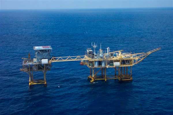
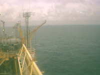
Station FGBL1 - High Island 334
|
||||||||||||||||||||||||||||||||||||||||||||||||||||||||||||||||||||||||||||||||||||||||||||||||||||||||||||||||||||||||||||||||||||||||||||||||||||||||||||||||||||||||||||||||||||||||||||||||||||||||||||||||||||||||||||||||||||||||||||||||||||||||||||||||||||||||||||||||||||||||||||||||||||||||||||||||||||||||||||||||||||||||||||||||||||||||||||||||||||||||||||||||||||||||||||||||||||||||||||||||||||||||||||||||||||||||||||||||||||||||||||||||||||||||||||||||||||||||||||||||||||||||||||||||||||||||||||||||||||||||||||||||||||||||||||||||||||||||||||||||||||||||||||||||||||||||||||||||||||||||||||||||||||||||||||||||||||||||||||||||||||||||||||||||||||||||||||||||||||||||||||||||||||||||||||||||||||||||||||||||||||||||||||||||||||||||||||||||||||||||||||||||||||||||||||||||||||||||||||||||||||||||||||||||||||||||||||||||||||||||||||||||||||||||||||||||||||||||||||||||||||||||||||||||||||||||||||||||||||||||||||||||||||||||||||||||||||||||||||||||||||||||||||||||||||||||||||||||||||||
Owned by Mariner Energy Inc. and maintained by Essi Corporation Latest NWS Marine Forecast 1 and Latest NWS Marine Forecast 2 |
|
Click on the graph icon in the table below to see a time series plot of the last five days of that observation. | ||
 | Wind Direction (WDIR): | NW ( 320 deg true ) |
| Wind Speed (WSPD): | 7.2 m/s |
| Wind Gust (GST): | 7.7 m/s |
| Air Temperature (ATMP): | 30.2 °C |
| Salinity (SAL): | 39.98 psu |
| Dew Point (DEWP): | 27.8 °C |
| Heat Index (HEAT): | 40.5 °C |
| Combined plot of Wind Speed, Gust, and Air Pressure | |
|
| | | | | | | | | | | | | | | ||||
| MM | DD | TIME (GMT) | WDIR | WSPD m/s |
GST m/s |
WVHT m |
DPD sec |
APD sec |
MWD | PRES mb |
PTDY mb |
ATMP °C |
WTMP °C |
DEWP °C |
SAL psu |
VIS km |
TIDE m | |
|---|---|---|---|---|---|---|---|---|---|---|---|---|---|---|---|---|---|---|
| 09 | 23 | 1850 | NW | 7.2 | 7.7 | - | - | - | - | - | - | 30.4 | - | 27.8 | 39.98 | - | - | |
| 09 | 23 | 1835 | NW | 6.7 | 7.7 | - | - | - | - | - | - | 30.5 | - | 27.9 | - | - | - | |
| 09 | 23 | 1820 | NW | 6.7 | 7.2 | - | - | - | - | - | - | 30.4 | - | 27.8 | - | - | - | |
| 09 | 23 | 1805 | NW | 7.7 | 8.2 | - | - | - | - | - | - | 30.5 | - | 27.8 | - | - | - | |
| 09 | 23 | 1750 | NW | 7.7 | 7.7 | - | - | - | - | - | - | 30.5 | - | 27.8 | - | - | - | |
| 09 | 23 | 1735 | NW | 7.2 | 7.7 | - | - | - | - | - | - | 30.9 | - | 28.3 | - | - | - | |
| 09 | 23 | 1718 | NW | 7.2 | 7.7 | - | - | - | - | - | - | 31.6 | - | 28.9 | 39.98 | - | - | |
| 09 | 23 | 1705 | NW | 7.7 | 8.2 | - | - | - | - | - | - | 30.9 | - | 28.3 | 39.98 | - | - | |
| 09 | 23 | 1650 | NW | 8.2 | 9.3 | - | - | - | - | - | - | 30.7 | - | 28.0 | - | - | - | |
| 09 | 23 | 1635 | NW | 7.2 | 8.2 | - | - | - | - | - | - | 30.8 | - | 28.2 | - | - | - | |
| 09 | 23 | 1605 | NW | 8.2 | 8.2 | - | - | - | - | - | - | 31.9 | - | 29.3 | - | - | - | |
| 09 | 23 | 1550 | NW | 7.7 | 8.2 | - | - | - | - | - | - | 31.0 | - | 28.4 | - | - | - | |
| 09 | 23 | 1530 | NNW | 7.2 | 8.2 | - | - | - | - | - | - | 31.5 | - | 28.7 | - | - | - | |
| 09 | 23 | 1520 | NNW | 7.7 | 8.8 | - | - | - | - | - | - | 31.4 | - | 28.4 | - | - | - | |
| 09 | 23 | 1505 | NNW | 8.2 | 9.3 | - | - | - | - | - | - | 31.3 | - | 28.7 | - | - | - | |
| 09 | 23 | 1450 | NW | 8.2 | 9.3 | - | - | - | - | - | - | 31.4 | - | 28.8 | - | - | - | |
| 09 | 23 | 1434 | NW | 8.2 | 9.3 | - | - | - | - | - | - | 31.4 | - | 28.8 | - | - | - | |
| 09 | 23 | 1409 | NNW | 8.2 | 9.3 | - | - | - | - | - | - | 31.2 | - | 28.5 | - | - | - | |
| 09 | 23 | 1405 | NW | 8.8 | 9.3 | - | - | - | - | - | - | 31.4 | - | 28.9 | - | - | - | |
| 09 | 23 | 1349 | NW | 9.3 | 9.8 | - | - | - | - | - | - | 31.3 | - | 28.7 | - | - | - | |
| 09 | 23 | 1335 | NW | 9.3 | 9.8 | - | - | - | - | - | - | 31.2 | - | 28.4 | - | - | - | |
| 09 | 23 | 1320 | NW | 9.8 | 10.8 | - | - | - | - | - | - | 32.0 | - | 28.7 | - | - | - | |
| 09 | 23 | 1305 | NW | 8.8 | 9.8 | - | - | - | - | - | - | 31.8 | - | 29.2 | 39.98 | - | - | |
| 09 | 23 | 1250 | NW | 8.8 | 9.8 | - | - | - | - | - | - | 31.6 | - | 29.1 | - | - | - | |
| 09 | 23 | 1235 | NW | 8.8 | 9.8 | - | - | - | - | - | - | 31.0 | - | 28.6 | - | - | - | |
| 09 | 23 | 1220 | NW | 9.3 | 9.8 | - | - | - | - | - | - | 31.3 | - | 29.0 | - | - | - | |
| 09 | 23 | 1205 | NW | 8.2 | 9.3 | - | - | - | - | - | - | 31.0 | - | 28.6 | - | - | - | |
| 09 | 23 | 1150 | NW | 9.8 | 10.3 | - | - | - | - | - | - | 30.9 | - | 28.4 | - | - | - | |
| 09 | 23 | 1135 | NW | 8.8 | 9.3 | - | - | - | - | - | - | - | - | - | - | - | - | |
| 09 | 23 | 1120 | NW | 8.2 | 9.3 | - | - | - | - | - | - | 32.6 | - | 30.2 | - | - | - | |
| 09 | 23 | 1026 | NW | 9.3 | 10.3 | - | - | - | - | - | - | 31.3 | - | 28.7 | - | - | - | |
| 09 | 23 | 1020 | NW | 9.3 | 10.3 | - | - | - | - | - | - | 31.4 | - | 28.8 | - | - | - | |
| 09 | 23 | 1005 | NW | 9.8 | 11.3 | - | - | - | - | - | - | 30.9 | - | 28.3 | - | - | - | |
| 09 | 23 | 0950 | NW | 10.8 | 11.3 | - | - | - | - | - | - | 30.8 | - | 28.0 | - | - | - | |
| 09 | 23 | 0935 | NW | 10.8 | 11.3 | - | - | - | - | - | - | 30.9 | - | 28.1 | - | - | - | |
| 09 | 23 | 0919 | NW | 10.3 | 11.3 | - | - | - | - | - | - | 30.7 | - | 28.1 | - | - | - | |
| 09 | 23 | 0903 | NW | 9.3 | 10.3 | - | - | - | - | - | - | 31.8 | - | 29.3 | 39.98 | - | - | |
| 09 | 23 | 0832 | NW | 9.8 | 10.8 | - | - | - | - | - | - | - | - | - | - | - | - | |
| 09 | 23 | 0811 | NW | 10.8 | 12.4 | - | - | - | - | - | - | 31.2 | - | 28.4 | - | - | - | |
| 09 | 23 | 0804 | NW | 11.3 | 12.4 | - | - | - | - | - | - | 31.5 | - | 28.7 | - | - | - | |
| 09 | 23 | 0741 | NW | 10.3 | 11.3 | - | - | - | - | - | - | 31.2 | - | 28.5 | - | - | - | |
| 09 | 23 | 0735 | NW | 10.8 | 12.4 | - | - | - | - | - | - | 31.0 | - | 28.2 | - | - | - | |
| 09 | 23 | 0720 | NW | 10.3 | 11.3 | - | - | - | - | - | - | 31.4 | - | 28.5 | - | - | - | |
| 09 | 23 | 0705 | NW | 10.8 | 11.3 | - | - | - | - | - | - | 30.9 | - | 28.1 | - | - | - | |
| 09 | 23 | 0650 | NW | 10.3 | 10.8 | - | - | - | - | - | - | 31.8 | - | 29.0 | - | - | - | |
| 09 | 23 | 0608 | NW | 10.3 | 11.3 | - | - | - | - | - | - | 32.0 | - | 29.4 | - | - | - | |
| 09 | 23 | 0604 | NW | 11.8 | 12.4 | - | - | - | - | - | - | 31.4 | - | 28.6 | - | - | - | |
| 09 | 23 | 0550 | NW | 11.3 | 12.4 | - | - | - | - | - | - | 31.6 | - | 29.0 | - | - | - | |
| 09 | 23 | 0535 | NW | 11.3 | 12.4 | - | - | - | - | - | - | - | - | - | - | - | - | |
| 09 | 23 | 0520 | NNW | 10.3 | 11.3 | - | - | - | - | - | - | 30.8 | - | 28.4 | - | - | - | |
| 09 | 23 | 0504 | NW | 10.3 | 11.3 | - | - | - | - | - | - | 31.6 | - | 28.8 | - | - | - | |
| 09 | 23 | 0450 | NNW | 9.3 | 10.8 | - | - | - | - | - | - | - | - | - | - | - | - | |
| 09 | 23 | 0435 | NNW | 10.3 | 11.3 | - | - | - | - | - | - | - | - | - | 39.98 | - | - | |
| 09 | 23 | 0419 | NW | 11.3 | 12.4 | - | - | - | - | - | - | 32.6 | - | 29.9 | - | - | - | |
| 09 | 23 | 0405 | NW | 11.3 | 12.4 | - | - | - | - | - | - | 31.8 | - | 29.1 | - | - | - | |
| 09 | 23 | 0350 | NW | 10.3 | 11.3 | - | - | - | - | - | - | 32.3 | - | 29.6 | - | - | - | |
| 09 | 23 | 0335 | NW | 11.3 | 11.8 | - | - | - | - | - | - | 32.8 | - | 29.4 | - | - | - | |
| 09 | 23 | 0320 | NW | 10.8 | 11.8 | - | - | - | - | - | - | 32.3 | - | 29.6 | - | - | - |
Disclaimer: Ocean current directions are measured to the nearest 10 degrees and speeds are measured to the nearest whole centimeter per second.
| 1920 GMT | 1905 GMT | 1850 GMT | 1835 GMT | 1820 GMT | 1805 GMT | 1750 GMT | 1735 GMT | |||||||||||||||||
|---|---|---|---|---|---|---|---|---|---|---|---|---|---|---|---|---|---|---|---|---|---|---|---|---|
| Depth m | Dir ° | Speed cm/s |
Dir ° | Speed cm/s |
Dir ° | Speed cm/s |
Dir ° | Speed cm/s |
Dir ° | Speed cm/s |
Dir ° | Speed cm/s |
Dir ° | Speed cm/s |
Dir ° | Speed cm/s |
||||||||
| 2 | 0 | 0.0 | 0 | 0.0 | 0 | 0.0 | 0 | 0.0 | 0 | 0.0 | 0 | 0.0 | 0 | 0.0 | 0 | 0.0 | ||||||||
Previous (up to 48) reports of ocean current data for FGBL1
Ocean Current Stick Plots are available in metric units only:
1-day plot
3-day plot
5-day plot
|
These oceanographic data are displayed in rounded times. Click on the graph icon in the table below to see a time series plot of the last five days of that observation. | ||
| Depth (DEPTH): | 2.0 m | |
| Ocean Temperature (OTMP): | 16.53 °C |
| Salinity (SAL): | 39.98 psu |
| | | | | | | | | ||||
| MM | DD | TIME (GMT) |
DEPTH m |
OTMP °C |
COND mS/cm |
SAL psu |
O2% % |
O2PPM ppm |
CLCON ug/l |
TURB FTU |
PH | EH mv |
|---|---|---|---|---|---|---|---|---|---|---|---|---|
| 09 | 23 | 1905 | 2.0 | 16.53 | - | 39.98 | - | - | - | - | - | - |
| 09 | 23 | 1850 | 2.0 | 16.53 | - | 39.98 | - | - | - | - | - | - |
| 09 | 23 | 1718 | 2.0 | 16.53 | - | 39.98 | - | - | - | - | - | - |
| 09 | 23 | 1305 | 2.0 | 16.47 | - | 39.98 | - | - | - | - | - | - |
| 09 | 23 | 0903 | 2.0 | 17.77 | - | 39.98 | - | - | - | - | - | - |
| 09 | 23 | 0435 | 2.0 | 16.42 | - | 39.98 | - | - | - | - | - | - |
Links which are specific to this station are listed below:
Real Time Data in tabular form for the last forty-five days.
Historical Data & Climatic Summaries for quality controlled data for the current month, previous months, and previous years.
| U.S. Dept. of Commerce National Oceanic and Atmospheric Administration National Weather Service National Data Buoy Center 1007 Balch Blvd. Stennis Space Center, MS 39529 Feedback Page last modified: September 18, 2008 |
Disclaimer Credits Glossary |
Privacy Policy About Us Career Opportunities |