

You are here: Home › Feature Stories › Nutrient Pollution of Coastal Waters—Too Much of a Good Thing
Nutrient Pollution of Coastal Waters—Too Much of a Good Thing
Nitrogen and phosphorous are essential nutrients for plant growth—from cash crops like corn and soybeans to the single–celled plants that inhabit the nation’s coastal waters. But too much of that growth in coastal water can cause harm, resulting in a type of pollution called eutrophication.

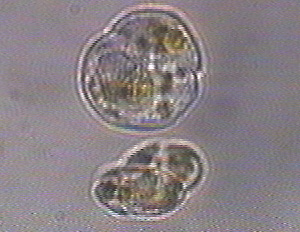
In coastal waters and in fresh water streams and lakes, excess nutrients cause explosive growth of suspended, drifting microscopic plants called algae. They can become so dense that they block sunlight needed for underwater grasses to grow. When the algae die, they drift to the bottom and decay, using up oxygen faster than it can be replenished from the surface. The results—oxygen poor conditions, called hypoxia, and completely depleted oxygen conditions, anoxia. Living things become stressed by those low–oxygen conditions: they simply cannot live without sufficient oxygen (See a diagram here). Areas where hypoxic conditions prevail often go by the popular vernacular "dead zones." (Scientists and experts often acknowledge that term as perhaps being more graphic and memorable than literal.)
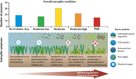
How serious is this problem for coastal waters? For many regions, nutrient pollution has emerged as the most widespread and measurable effect of pollution on living resources and biodiversity. A decade ago, NOAA’s first nationwide assessment of estuarine eutrophication found that more than 64 percent of estuaries had moderate to high levels of eutrophication typically associated with dense mats of algae. Some showed more serious symptoms, including loss of sea grasses, toxic algal blooms, and oxygen depletion.
More than half of U.S. estuaries experience hypoxia during the year, and the number of "dead zones" in the U.S. and worldwide is increasing. For example, 149 such areas were documented worldwide in 2004, and 200 in 2006.
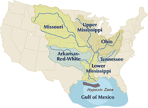
The largest and most widely publicized of the U.S. "dead zones," at the mouth of the Mississippi River, encompasses as much as 8,500 square miles in area, about the size of Massachusetts. The source of the nutrients? Over–fertilization of the Mississippi’s waters from farms, towns and factories in the nation’s midsection, many as much as 1,000 miles up stream. The nitrogen load to the northern Gulf of Mexico today is three times what it was 50 years ago. And the average size of the dead zone in the past decade is over twice the mean size measured in the 1980s.
Of the two elements, nitrogen is the chief culprit for eutrophication of temperate coastal waters. Comprising 78 percent of Earth’s atmosphere, nitrogen is a building block of both plant and animal tissue. It is also concentrated in human sewage and animal manure and in agricultural fertilizers, and it is a byproduct from combustion of fossil fuels.
Taming Pollution from Nonpoint Water Pollution Sources

Over the past three–plus decades, the U.S. has made substantial progress under the Clean Water Act and other programs in reducing nitrogen outputs from "point sources" such as sewage treatment plants and industrial discharge pipes. Water pollution experts see "nonpoint" sources as a remaining major challenge. These releases don’t come from single discernible discharge pipes, but rather from area–wide sources—agricultural practices, residences and numerous small businesses, and runoff from highways and roads and even sources such as golf courses. Collectively, they lead to discharges of nitrogen into ground water, surface waters, and also the air.
Tackling pollution from these diverse nonpoint sources—and also from nonpoint sources of atmospheric air pollutants—is especially difficult, even more so in coastal areas where populations tend to concentrate and where fragile coastal ecosystems may be highly vulnerable.
Nutrient Pollution: Nationwide, Global…and Growing
This past summer, ongoing NOAA research efforts into eutrophication and its various manifestations reported further evidence that coastal ecosystems are at risk from what happens on the land, often many miles upstream and beyond the typical domain of coastal and ocean managers. The research confirms that nutrient pollution of coastal waters is a nationwide and global problem showing no signs of abating.
These research efforts demonstrate also that the extent of ecosystem degradation from nutrient pollution varies from one location to the next and that it is dependent on numerous factors—with both healthy and highly degraded systems sometimes existing in close proximity within the same region.
Many estuaries in South Carolina, for example don’t show signs of severe eutrophication because of their large tidal range and flushing. Just up the coast, in North Carolina, micro–tidal estuaries in Pamlico Sound are very susceptible to eutrophication and receive heavy loads of nutrients from agricultural runoff.
Similarly, nutrient stimulated blooms of Karenia brevis are a seasonal problem for areas along Florida’s southwest coast, perhaps made more severe by the influx of nutrients from the Mississippi plume. By contrast, Karenia blooms in northwest Florida and off Texas are less frequent and less likely to reach the coast—despite their proximity to the same nutrient source.
NCCOS–sponsored research is helping to clarify what factors cause extreme eutrophication events in the nation’s estuaries. That research is leading to increasingly accurate forecasts of when and where these events will occur. National surveys, such as the recently updated estuarine eutrophication assessment, support action on a regional and national scale, for example to identify and target those areas most at risk.
National Reports…with Applications ‘Close to Home’
These same nationwide reports put information on individual estuaries into the hands of local managers so they can evaluate conditions close to home and evaluate those conditions relative to other areas in the region. Identifying those major sources of nutrients, explains estuarine eutrophication assessment report author Suzanne Bricker, "is the first step to development of potential management solutions."
In July 2007, NOAA’s Center for Coastal Monitoring and Assessment (CCMA) released a 10–year update to the national estuarine eutrophication assessment report.

"Observations have confirmed that our nation’s coastal waters are stressed," said retired Navy Vice Admiral Conrad C. Lautenbacher, Ph.D., Under Secretary of Commerce for Oceans and Atmosphere and NOAA Administrator, commenting on the significance of the Assessment. "One thing we have learned from this study is that while the accumulation of nutrients in our estuaries has been stable for most of our estuaries, conditions are likely to worsen. The potential for serious degradation in most of our estuaries necessitates that we reinvigorate efforts to address nutrient pollution, and this study helps confirm that an ecosystem approach is required for improving the health of estuaries."
The report, Effects of Nutrient Enrichment in the Nation’s Estuaries: A Decade of Change, National Estuarine Eutrophication Assessment Update, examines eutrophic conditions in 141 U.S. estuaries, and how and why conditions have changed in the decade since the first assessment was issued. Of the 99 estuaries with data adequate for evaluation, 64 have moderate to high level nutrient impacts.
The study’s conclusions: Nutrient pollution is a global problem, affecting every region in the U.S., and most estuaries are "highly influenced" by human activities. While conditions have remained stable over all, many estuaries risk serious degradation in the future as coastal populations continue to increase.
The most susceptible estuaries, according to the report, are those with high nitrogen loads relative to their dilution and flushing capacity. It attributed these high nitrogen loads largely to expanding and dense coastal human populations.
10 Year Estuaries Forecast Sees More Troubles Ahead
While each of the five regions in the study reported systems with moderate to high impacts, the Mid Atlantic region, stretching from Cape Cod to the Chesapeake Bay, was the most impaired. The North Atlantic Region, from Maine to Cape Cod, was the least impaired. According to the study, other less impaired regions exhibited conditions that could make them susceptible to future degradation, particularly as populations increase along the coast.
"The different physical characteristics of these systems—for instance freshwater inflow, depth and volume, stratification potential, tidal exchange and other factors—determine the amount of time water and nutrients remain in the system," Bricker explains. "In effect, the same amount of nutrient added to these two different types of systems would cause more serious problems in restricted systems having long water residence times than in systems with good exchange and short residence times."
In the next decade, the report says, conditions are likely to worsen in 65 percent of the nation’s estuaries—with only 20 percent showing improvement.
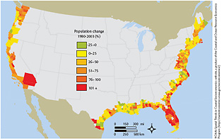
Why? The reason, quite simply, is people, says Bricker. "The study showed clearly that the main sources of nutrients were all related to human activities within the coastal watersheds. As coastal populations increase, they put an increased stress and pressure on the infrastructure that exists to deal with nutrient–related wastes. And we know that even now, that infrastructure is not keeping up with the load."
Case studies in the report, both from the U.S. and abroad, illustrate how impacts of eutrophication vary with the physical characteristics of each type of system, and how aggressive management measures, in a few isolated cases, have successfully reduced eutrophication.
In July, NCCOS researchers and CSCOR–sponsored researcher R. Eugene Turner of Louisiana State University predicted that the dead zone at the mouth of the Mississippi River would be relatively large—tied to record amounts of nitrogen from spring runoff.
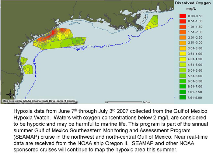
An NCCOS–sponsored survey cruise conducted by Nancy Rabelais, of the Louisiana Universities Marine Consortium, indicated that the dead zone was the third largest on record since annual measurements began in 1985. The observed area, 7,900 square miles, was just 7 percent smaller than Turner had predicted. The model is based on nitrate loads from the Mississippi and Atchafalaya rivers in May and incorporates the previous year’s load. The closeness of the model predictions in this and previous years suggests a consistent association between springtime nitrate loading and hypoxic zone area.
Over the past four years, NOAA and its collaborators have worked with two models to further strengthen dead zone forecasts. The LSU model is the most accurate, based on past performance. Further research is needed to turn these modeling efforts into an operational forecast.
The Northern Gulf of Mexico hypoxic zone is the focus of the largest inter–agency ecosystem management effort in the Nation to address the serious threat of nutrient pollution. Research and observations leading to these models are part of a larger NOAA sponsored effort to better understand the causes and effects of hypoxia on the northern Gulf of Mexico ecosystem, and better predict the extent of the hypoxic zone and its implications for commercially important aquatic species. NCCOS has a very active presence in the region—through its leadership and coordination of interagency efforts to better understand nutrient pollution, and through its research activities.

Previous research by NCCOS and others points to a clear link between nutrient loadings and the large hypoxic area in the northern Gulf of Mexico. Of particular interest to NCCOS scientists today are the water quality impacts of increased corn production driven by increased demand for corn as an ethanol feedstock. Measurements in the spring of 2007 reported record spring runoff into the Mississippi.
Why the concern? NCCOS/CSCOR Director Robert E. Magnien explains: "Experts in agriculture have called what we’re witnessing right now perhaps the most dramatic and swift change ever in the Nation’s agricultural landscape. Virtually overnight, the price of corn has almost doubled, and this is having profound effects on agricultural practices, including changes in crop rotations, use of marginal or retired lands, and increases in fertilizer application."
Expanding Applications for NCCOS’s ‘Ecological Forecasting’
The annual dead zone prediction is an example of the pioneering "ecological forecasting" capabilities of NOAA and its partners. Another example are the HAB Bulletins that use satellite imagery, field observations and buoy data to provide information on the location, extent, and potential for development or movement of Karenia brevis blooms in the Gulf of Mexico.
"We believe such forecasts will become important tools for coastal managers in the coming years," says David Whitall, a NOAA scientist involved in this project.
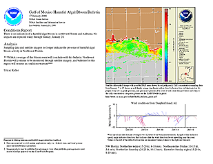
The same nutrient and sediment rich plume that lowers oxygen levels in the Gulf may manifest itself in other ways. Another group of NCCOS scientists reported on a proposed link between the nutrient–rich Mississippi plume and tides of toxic Karenia algal blooms that occur frequently along the west coast of Florida during late summer and fall. Those blooms cause serious health problems and shellfish harvesting closures, and they can wreak havoc on local tourism.
NCCOS researchers Richard P. Stumpf, R. Wayne Litaker, Lyon Lanerolle, and Patricia A. Tester have come up with the model to explain the development of blooms of the toxic dinoflagellates throughout the Gulf of Mexico. Their study (Hydrodynamic accumulation of Karenia off the west coast of Florida), published online at Continental Shelf Research and in print in January 2008, goes further than previous studies in showing a link between nutrient pollution from the Mississippi plume and Florida’s "red tides."
That linkage had not been previously established, explains Stumpf. "In the past, the effort has focused on the low salinity water. This study found that nutrients that fall out of the bloom and are remineralized travel further than the bloom itself."
The "hydrodynamic concentration model" presented in their work explains how various seasonal wind and circulation patterns combine with river inputs each year to produce toxic Karenia spp. blooms along Florida’s west coast. These blooms occur frequently during late summer to fall and can extend for hundreds to thousands of square kilometers.
According to the researchers’ hypothesis, nutrients from the Gulf of Mexico start the bloom process each summer, transported by circulation driven by normal summer northward winds. The Mississippi is the major source of these nutrients, particularly to subsurface waters. A change in wind direction each fall causes upwelling and transport of nutrients and vertically migrating Karenia cells towards the shore.
Stumpf and his colleagues see the study resulting in better predictions for those living along the affected coastline. The study results, Stumpf says, will improve the capability of the HAB bulletins to predict the onset of blooms, and the results may also pave the way for better forecasting the severity of a bloom season.
For NCCOS scientists and their collaborators probing the challenges posed by too much nitrogen and phosphorous in the nation’s coastal waters—indeed, much too much of a good thing—it’s all in a day’s, a week’s, a year’s and sometimes a career’s scientific research and work. The real satisfactions for many come in seeing the products of their research paying off and moving from the laboratory and the field to day–to–day practical applications at the local level.
Other recent articles
- NCCOS’s Energy Conservation Measures: What You Can’t See Matters A Whole Lot
- NCCOS’s Puzzle Piece in Solving the Oceans/Health Continuum
- From Research to Field Applications… Like Bridging Death Valley?
- Research from Atoms… to Ecosystems: New NMR Technology Shows Great Promise
- The NCCOS "S" Stands for Science: And It Also Stands for SAFETY
Related Links
- Nutrient Pollution Report Forecasts Worsening Health for Nation’s Estuaries
- Q&A: Rob Magnien Discusses Biofuel Energy Challenges
- Scientists Work for a Better Understanding of Gulf of Mexico Hypoxia Causes and Cures
- Gulf of Mexico Ecosystems & Hypoxia Assessment (NGOMEX)
- Hypoxia & Nutrient Pollution research overview