
Gobi Forage Project: An Early Warning System for Livestock in the Gobi Region of Mongolia
During the period from 1999 to 2002, Mongolia experienced a series of droughts and severe winters that significantly lowered livestock numbers. Specifically, livestock mortality in the Gobi region reached as much as 50% with many losing entire herds.
Learn more
Mali Livestock and Pastoralist Initiative
Global Livestock Collaborative Research Support Program (GL-CRSP) initiated the Mali Livestock and Pastoralist Initiative (MLPI) project. The objective of this effort was to take successful technologies and tools and transfer them to

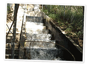
Verification of Impacts of BMPs on Water Quality
Richland-Chambers Reservoir is the largest reservoir maintained by Tarrant Regional Water District supplying water to a major portion of the 1.5 million people in north-central Texas. It is listed with high pH, nutrient enrichment, and algal growth due to excess nitrates.Learn more

Seamless Daily Precipitation and Temperature Spatial Data
Spatial time series of daily precipitation and temperature data sets were developed for the entire 48 conterminous states in the U.S. These data sets were developed to meet spatial and temporal requirements.Learn more

Landscape Inference Model (LSIM)
This project is designed to develop and test the utility of GIS mapping technology developed in previous projects for the North Bosque for performing NRCS soil surveys at the 1:24,000 scale used in detailed soil survey (county level) studies.Learn more

Modeling Water Issues in the North Bosque Watershed
This project, initiated in FY2005, is one of six nationally selected studies as part of the CEAP Special Emphasis Watersheds. The Shuttle Radar Terrain Mapping (SRTM) 30 meter elevation data and Thematic Mapper (TM) Satellite data are being used in this project.Learn more

Watershed Conservation on Grazing Lands in Central Texas: Cowhouse Creek Case Study
Rangelands continue to degrade at an accelerated pace. Drivers of these changes can include rising atmospheric CO2, desertification, woody plant encroachment, and invasion of non-native species.Learn more

Conservation Effects Assessment Project
The environmental benefits of the 1996 Farm Bill have not been previously quantified for reporting at the national scale; in addition, there are few research studies designed to measure the larger effects.Learn more

Fort Hood Water Quality Monitoring Program
Fort Hood’s most prevalent problem is training area soil erosion. The training areas are subject to heavy traffic volumes on grasslands during military maneuvers which results in compacted soils and vegetation loss leading to severe erosion and sedimentation of area streams and lakes.Learn more

Lampasas River Watershed Protection Plan
The Lampasas River above Stillhouse Hollow Lake is listed as impaired on the Texas Water Quality Inventory and 303(d) List due to elevated bacteria levels. Surface water quality monitoring also indicates a dissolved oxygen impairment on North Fork Rocky Creek.Learn more

Monitoring Water Quality in the Leon River Watershed
The Leon River Watershed in Central Texas feeds Lake Belton and supplies more than 250,000 residents with water resources. Texas AgriLife Research, Blackland Research and Extension Center (BREC) installed and maintains two main-stem river sampling sites located near Hamilton and Gatesville, and USDA-ARS installed and maintains nine field-scale and small watershed sites in the watershed.Learn more

Fort Hood Training Area Revegetation Program
Fort Hood, Texas, the Army’s pre-eminent armor training facility, currently supports the equivalent of two mechanized armored divisions plus a multitude of combat brigade teams from other military installations that utilize the post.Learn more
SWAT Model Simulation of the Arroyo Colorado Watershed
The Arroyo Colorado watershed has a history of poor water quality. The impairment of water quality is due to the presence of high levels of bacteria and low dissolved oxygen that is responsible for fish kills. The low Dissolved Oxygen (DO) is mainly attributed to the nutrient loading from the agricultural fields, wastewater treatment plants, and urban storm water flows.Learn more

Environmental Credits Trading
Carbon trading systems are already in place, yet, no standard mechanism is available to quantify environmental benefits of management practices at the individual farm or watershed level.Learn more
Verification of Impacts of BMPs on Water Quality
Richland-Chambers Reservoir is the largest reservoir maintained by Tarrant Regional Water District supplying water to a major portion of the 1.5 million people in north-central Texas. It is listed with high pH, nutrient enrichment, and algal growth due to excess nitrates.Learn more

Trinity River Basin Environmental Restoration Initiative
Watershed management through water modeling and water conservation education are some the most cost-effective practices available to ensure a safe and reliable public water supply.Learn more
Subscribe What's New
- Dyke leads stateside support team for Texas National Guard Agribusiness Development team
- Blackland Research and Extension Center Scientists Team up with Italian Scientists
- Study looks at impact of conservation
- Special Issue SWAT: A Review of Advances in Ecohydrological Modelling with SWAT
- A dirty job but someone gets to do it: Grassland lab receives $400,000 grant to study biosolid fertilizer
- Browse the archives

State Link Policy · Report Fraud, Waste and Abuse · Texas Homeland Security · Open Records/Public Information