
 Feeds & Data
Magnitude 7.4 - EAST OF THE KURIL ISLANDS
2009 January 15 17:49:39 UTC
Earthquake Details
| Magnitude | 7.4 |
|---|---|
| Date-Time |
|
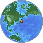
| Location | 46.862°N, 155.156°E |
| Depth | 36 km (22.4 miles) set by location program |
| Region | EAST OF THE KURIL ISLANDS |
| Distances | 435 km (270 miles) S of Severo-Kuril'sk, Kuril Islands, Russia 595 km (370 miles) ENE of Kuril'sk, Kuril Islands 1785 km (1110 miles) NE of TOKYO, Japan 7245 km (4500 miles) NE of MOSCOW, Russia |
| Location Uncertainty | horizontal +/- 3.6 km (2.2 miles); depth fixed by location program |
| Parameters | NST=369, Nph=369, Dmin=731.2 km, Rmss=0.87 sec, Gp= 14°, M-type=regional moment magnitude (Mw), Version=U |
| Source |
|
| Event ID | us2009bwa8 |
- This event has been reviewed by a seismologist.
- Did you feel it? Report shaking and damage at your location. You can also view a map displaying accumulated data from your report and others.
Earthquake Summary

Tectonic Summary
The Kuril Islands earthquake of January 15th, 2009 occurred as a result of thrust faulting within the Pacific plate. The event occurred near the outer-rise of the Pacific plate about 30 km to the east of where the Pacific plate subducts beneath the Okhotsk plate. In this region, the Pacific plate moves northwest with respect to the Okhotsk plate with a velocity of about 90 mm/yr.
Large and great earthquakes are not uncommon in this region. The location of this event is approximately 90 km to the northeast of the Mw 8.1 outer rise earthquake of January 13th 2007, which occurred as a result of normal faulting near the Pacific plate outer-rise. On November 15th 2006, an Mw 8.3 subduction-related thrust earthquake occurred approximately 160km to the southwest.
 Tsunami Information
- NOAA West Coast & Alaska Tsunami Warning Center
- NOAA Pacific Tsunami Warning Center
- Tsunami Information Links
The earthquake locations and magnitudes cited in these NOAA tsunami bulletins are very preliminary and may be superceded by USGS locations and magnitudes computed using more extensive data sets.
Earthquake Maps


Scientific & Technical Information

- Preliminary Earthquake Report
- U.S. Geological Survey, National Earthquake Information Center:
World Data Center for Seismology, Denver
