
 Feeds & Data
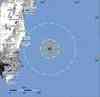
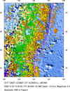
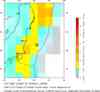
Magnitude 6.3 - OFF THE EAST COAST OF HONSHU, JAPAN
2008 December 20 10:29:21 UTC
Earthquake Details
| Magnitude | 6.3 |
|---|---|
| Date-Time |
|
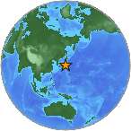
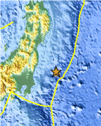
| Location | 36.538°N, 142.420°E |
| Depth | 10 km (6.2 miles) set by location program |
| Region | OFF THE EAST COAST OF HONSHU, JAPAN |
| Distances | 145 km (90 miles) ESE of Iwaki, Honshu, Japan 175 km (110 miles) E of Mito, Honshu, Japan 215 km (135 miles) SE of Fukushima, Honshu, Japan 260 km (160 miles) ENE of TOKYO, Japan |
| Location Uncertainty | horizontal +/- 3.9 km (2.4 miles); depth fixed by location program |
| Parameters | NST=273, Nph=273, Dmin=377.6 km, Rmss=0.87 sec, Gp= 29°, M-type=regional moment magnitude (Mw), Version=R |
| Source |
|
| Event ID | us2008avan |
- This event has been reviewed by a seismologist.
- Did you feel it? Report shaking and damage at your location. You can also view a map displaying accumulated data from your report and others.
Earthquake Summary
Felt Reports
Felt at Fukushima, Warabi and Yokohama.
 Tsunami Information
- NOAA West Coast & Alaska Tsunami Warning Center
- NOAA Pacific Tsunami Warning Center
- Tsunami Information Links
The earthquake locations and magnitudes cited in these NOAA tsunami bulletins are very preliminary and may be superceded by USGS locations and magnitudes computed using more extensive data sets.
Earthquake Maps

Scientific & Technical Information

- Preliminary Earthquake Report
- U.S. Geological Survey, National Earthquake Information Center:
World Data Center for Seismology, Denver
