
 Feeds & Data
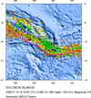
Magnitude 5.6 - SOLOMON ISLANDS
2009 January 15 16:15:01 UTC
Earthquake Details
| Magnitude | 5.6 |
|---|---|
| Date-Time |
|
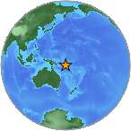
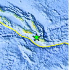
| Location | 10.327°S, 161.260°E |
| Depth | 112.1 km (69.7 miles) |
| Region | SOLOMON ISLANDS |
| Distances | 75 km (45 miles) W of Kira Kira, San Cristobal, Solomon Isl. 170 km (105 miles) ESE of HONIARA, Guadalcanal, Solomon Islands 185 km (115 miles) SSE of Auki, Malaita, Solomon Islands 2085 km (1300 miles) NNE of BRISBANE, Queensland, Australia |
| Location Uncertainty | horizontal +/- 6.4 km (4.0 miles); depth +/- 11.7 km (7.3 miles) |
| Parameters | NST=163, Nph=163, Dmin=174.7 km, Rmss=1 sec, Gp= 36°, M-type=regional moment magnitude (Mw), Version=Q |
| Source |
|
| Event ID | us2009bwaz |
- This event has been reviewed by a seismologist.
- Did you feel it? Report shaking and damage at your location. You can also view a map displaying accumulated data from your report and others.
Earthquake Summary
 Tsunami Information
- NOAA West Coast & Alaska Tsunami Warning Center
- NOAA Pacific Tsunami Warning Center
- Tsunami Information Links
The earthquake locations and magnitudes cited in these NOAA tsunami bulletins are very preliminary and may be superceded by USGS locations and magnitudes computed using more extensive data sets.
Earthquake Maps


Scientific & Technical Information

- Preliminary Earthquake Report
- U.S. Geological Survey, National Earthquake Information Center:
World Data Center for Seismology, Denver
