
 Feeds & Data
Magnitude 5.2 - BOUGAINVILLE REGION, PAPUA NEW GUINEA
2009 January 14 04:49:00 UTC
Earthquake Details
| Magnitude | 5.2 |
|---|---|
| Date-Time |
|
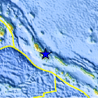
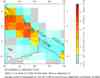
| Location | 6.502°S, 155.696°E |
| Depth | 180.3 km (112.0 miles) |
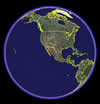
| Region | BOUGAINVILLE REGION, PAPUA NEW GUINEA |
| Distances | 35 km (20 miles) SSE of Arawa, Bougainville, PNG 105 km (65 miles) W of Chirovanga, Choiseul, Solomon Islands 990 km (620 miles) ENE of PORT MORESBY, Papua New Guinea 2340 km (1450 miles) N of BRISBANE, Queensland, Australia |
| Location Uncertainty | horizontal +/- 8 km (5.0 miles); depth +/- 15.4 km (9.6 miles) |
| Parameters | NST= 71, Nph= 71, Dmin=569.8 km, Rmss=0.94 sec, Gp= 65°, M-type=body magnitude (Mb), Version=7 |
| Source |
|
| Event ID | us2009bvam |
- This event has been reviewed by a seismologist.
- Did you feel it? Report shaking and damage at your location. You can also view a map displaying accumulated data from your report and others.
Earthquake Summary

Earthquake Information for Australia
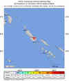
 Tsunami Information
- NOAA West Coast & Alaska Tsunami Warning Center
- NOAA Pacific Tsunami Warning Center
- Tsunami Information Links
The earthquake locations and magnitudes cited in these NOAA tsunami bulletins are very preliminary and may be superceded by USGS locations and magnitudes computed using more extensive data sets.
Earthquake Maps
Scientific & Technical Information
 Historic Moment Tensor Solutions
- Preliminary Earthquake Report
- U.S. Geological Survey, National Earthquake Information Center:
World Data Center for Seismology, Denver
