
 Feeds & Data
Magnitude 5.0 - FLORES SEA
2009 January 14 11:09:18 UTC
Earthquake Details
| Magnitude | 5.0 |
|---|---|
| Date-Time |
|
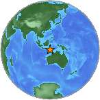
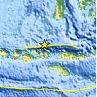
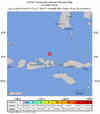
| Location | 7.755°S, 118.681°E |
| Depth | 35 km (21.7 miles) set by location program |
| Region | FLORES SEA |
| Distances | 75 km (50 miles) N of Raba, Sumbawa, Indonesia 300 km (185 miles) SSW of Ujung Pandang, Sulawesi, Indonesia 335 km (210 miles) ENE of Mataram, Lombok, Indonesia 1335 km (830 miles) E of JAKARTA, Java, Indonesia |
| Location Uncertainty | horizontal +/- 16.8 km (10.4 miles); depth fixed by location program |
| Parameters | NST= 23, Nph= 23, Dmin=325.4 km, Rmss=1.14 sec, Gp=122°, M-type=body magnitude (Mb), Version=7 |
| Source |
|
| Event ID | us2009bva7 |
- This event has been reviewed by a seismologist.
- Did you feel it? Report shaking and damage at your location. You can also view a map displaying accumulated data from your report and others.
Earthquake Summary
Earthquake Information for Asia
Earthquake Information for Indonesia
 Tsunami Information
- NOAA West Coast & Alaska Tsunami Warning Center
- NOAA Pacific Tsunami Warning Center
- Tsunami Information Links
The earthquake locations and magnitudes cited in these NOAA tsunami bulletins are very preliminary and may be superceded by USGS locations and magnitudes computed using more extensive data sets.
Earthquake Maps

Scientific & Technical Information
 Historic Moment Tensor Solutions
- Preliminary Earthquake Report
- U.S. Geological Survey, National Earthquake Information Center:
World Data Center for Seismology, Denver
