
 Feeds & Data
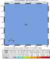
Magnitude 6.0 - MID-INDIAN RIDGE
2009 January 13 01:04:42 UTC
Earthquake Details
| Magnitude | 6.0 |
|---|---|
| Date-Time |
|
| Location | 13.194°S, 66.060°E |
| Depth | 10 km (6.2 miles) set by location program |
| Region | MID-INDIAN RIDGE |
| Distances | 775 km (480 miles) NNE of Rodrigues Island, Mauritius 945 km (590 miles) SW of Diego Garcia, Chagos Archipelago 1200 km (740 miles) NE of PORT LOUIS, Mauritius 2700 km (1670 miles) SW of COLOMBO, Sri Lanka |
| Location Uncertainty | horizontal +/- 10.5 km (6.5 miles); depth fixed by location program |
| Parameters | NST=157, Nph=157, Dmin=948.2 km, Rmss=1.25 sec, Gp= 68°, M-type=regional moment magnitude (Mw), Version=R |
| Source |
|
| Event ID | us2009buad |
- This event has been reviewed by a seismologist.
- Did you feel it? Report shaking and damage at your location. You can also view a map displaying accumulated data from your report and others.
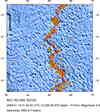
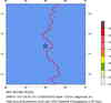
Earthquake Maps


Scientific & Technical Information

- Preliminary Earthquake Report
- U.S. Geological Survey, National Earthquake Information Center:
World Data Center for Seismology, Denver
