
 Feeds & Data
Magnitude 5.0 - OFF EAST COAST OF THE NORTH ISLAND, N.Z.
2009 January 10 11:53:21 UTC
Earthquake Details
| Magnitude | 5.0 |
|---|---|
| Date-Time |
|
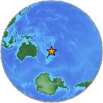
| Location | 35.364°S, 178.938°E |
| Depth | 175.7 km (109.2 miles) set by location program |
| Region | OFF EAST COAST OF THE NORTH ISLAND, N.Z. |
| Distances | 375 km (235 miles) NNE of Gisborne, New Zealand 385 km (240 miles) NE of Rotorua, New Zealand 410 km (255 miles) ENE of Auckland, New Zealand 750 km (465 miles) NNE of WELLINGTON, New Zealand |
| Location Uncertainty | horizontal +/- 13.3 km (8.3 miles); depth fixed by location program |
| Parameters | NST= 24, Nph= 23, Dmin=486.6 km, Rmss=1.03 sec, Gp=133°, M-type=body magnitude (Mb), Version=S |
| Source |
|
| Event ID | us2009bras |
- This event has been reviewed by a seismologist.
- Did you feel it? Report shaking and damage at your location. You can also view a map displaying accumulated data from your report and others.

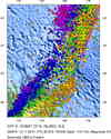
Earthquake Maps


Scientific & Technical Information
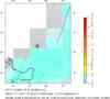
 Historic Moment Tensor Solutions
- Preliminary Earthquake Report
- U.S. Geological Survey, National Earthquake Information Center:
World Data Center for Seismology, Denver
