QUESTIONS
Ask New York USGS
DATA CENTER
ABOUT THE New York
WSC
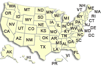
USGS IN YOUR STATE
USGS Water Science Centers are located in each state.
|
Water Resources of New York
Welcome to the U.S. Geological Survey (USGS) Web page for the water resources of New York; this is your direct link to all kinds of water-resource information. Here you'll find information on New York's rivers, lakes, and estuaries. You'll also find information about ground water, water quality, and many other topics. The USGS operates the most extensive satellite network of stream- and tide-gaging stations in the state, many of which form the backbone of flood-warning systems.
The USGS provides current ("real-time") stream stage and surface-water, water-quality, and ground-water levels for over 300 sites in New York.
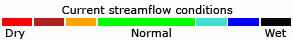
Streamflow Conditions in New York
Current Streamflow Conditions in New York

Coastal Conditions in Southeastern New York
|
News


Featured Projects
New York Water Quality Network
The New York District of the U.S. Geological Survey operates a water quality network throughout the New York City Watershed funded by New York City Department of Environmental Protection. The purpose of the network is to provide surface water stream flow and water quality data for selected streams throughout the Catskill Mountains within the New York City Watershed..... Find out more Find out more
What's in that Water? USGS Releases First Nationwide Look At Pharmaceuticals, Hormones And Other Organic Contaminants In U.S. Streams
Recent decades have brought increasing concerns for potential contamination of water resources that could result inadvertently during production, use, and disposal of the numerous chemicals offering improvements in industry, agriculture, medical treatment, and even common household conveniences. Increasing knowledge of the environmental occurrence or toxicological...Find out more
...Continued
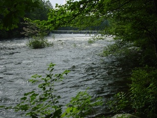
Effects of recreational flow releases on natural resources of the Indian and Hudson Rivers
The New York State Department of Environmental Conservation (NYSDEC) is developing a unit management plan/environmental impact statement (UMP/EIS) for the Hudson Gorge Primitive Area, an area of Forest Preserve land encompassing a scenic stretch of the Hudson River in the Adirondack Park......Find out more
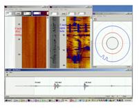
Borehole Geophysics
Borehole geophysics is the science of recording and analyzing measurements of physical properties made in wells or test holes. Probes that measure different properties are lowered into the borehole to collect continuous or.....Find out more
Recent Publications
- Benotti, M.J., 2008, Inventory of data sources used for watershed condition assessments of Fire Island National Seashore, Gateway National Recreation Area, and Sagamore Hill National Historic Site, New York and New Jersey: U.S. Geological Survey Open-File Report 2008–1298, 11 p., online only.
- Coon, W.F., 2008, Hydrologic Evidence of Climate Change in Monroe County, New York: U.S. Geological Survey Open-File Report 2008–1199, 12 p.
- Ernst, A.G., Baldigo, B.P., Schuler, G.E., Apse, C.D., Carter, J.L., and Lester, G.T., 2008, Effects of habitat characteristics and water quality on macroinvertebrate communities along the Neversink River in southeastern New York, 1991–2001: U.S. Geological Survey Scientific Investigations Report 2008–5024, 15 p.
- McHale, M.R., Murdoch, P.S., Burns, D.A., and Baldigo, B.P., 2008, Effects of forest harvesting on ecosystem health in the headwaters of the New York City water supply, Catskill Mountains, New York: U.S. Geological Survey Scientific Investigations Report 2008–5057, 22 p.
- Miller, T.S., Bugliosi, E.F., and Reddy, J.E., 2008, Geohydrology of the unconsolidated valley-fill aquifer in the Meads Creek valley, Schuyler and Steuben Counties, New York: U.S. Geological Survey Scientific Investigations Report 2008–5122, 32 p, online only.
|
|
| | | |