 |
 | |
  | |
|
|
|
|
Redwood National and State Parks
Directions
|
|
|
directions includes: | Maps
|  | | | |
|
|
|
 |
|
Arriving by plane: Crescent City Airport, 202 Dale Rupert Road, Crescent City, (707) 464-7311, United Express operated by SkyWest 800-864-8331 . Eureka-Arcata Airport, Arcata, Delta Air Lines operated by SkyWest, or Horizon Air, 800-547-9308 .
Arriving by car: From the north or south, use U.S. Highway 101. From the northeast, use U.S. Highway 199. From 101: Access additional park sites via the Bald Hills Road, Davison Road, Newton B. Drury Scenic Parkway, Coastal Drive, Requa Road, and Enderts Beach Road (south to north). From 199, take South Fork Road to Howland Hill Road.
Local public transportation: Redwood Coast Transit travels from Crescent City to Arcata, (707) 464-9314, Top of Page
Getting Around Drive to Redwood National and State Parks' many sites. Nearly 200 miles of walking and hiking trails await you. Horses are welcome on Little Bald Hills Trail, Mill Creek Horse Trails, and Orick Horse Trails. Bicycle on designated trails only. Pick up a visitor guide or stop by one of the five visitor centers and talk to a ranger about rules and regulations. *NOTE* There is no longer a shuttle bus that operates anywhere in the parks. Top of Page
|
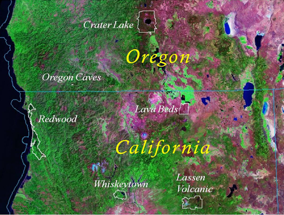
Plan to visit the Circle of Parks in the Klamath region of southern Oregon and northern California. See map below.
- National Park, 3½ hours from Crescent City, CA, 140 miles
- National Monument, 1½ hours from Crescent City, CA, 60 miles
- National Recreation Area, 4¼ hours from Crescent City, CA, 215 miles
- National Park, 5 hours from Crescent City, CA, 230 miles
- National Monument, 6 hours from Crescent City, CA
|

|
| NPS |
| The Klamath region covers northern California and southern Oregon including the "Circle of Parks" above. |
|
|  |  |

|
 |
|
|
|
|
|
 |
|
Did You Know?
Steller's jays are noisey campground residents and take advantage of unnatural human food sources. Normally feeding on seeds and nuts, jays also prey on the endangered marbled murrelet and their chicks. Please help to protect the robin-sized murrelet by not sharing your lunch with any wildlife.
|
|
|
|
Last Updated: January 15, 2009 at 18:31 EST |


