


)
National Mosaic & Q2 System
Accurate quantitative precipitation estimates (QPE) and very short-term quantitative precipitation forecasts (VSQPF) are critical to fresh water management in the United States and around the world. National Weather Service (NWS) forecasters have documented their need for better operational products. River Forecast Centers need more accurate QPE/VSQPF and better knowledge of QPE uncertainties and their impacts on river forecasts. Weather Forecast Offices require the same for improved flash flood warnings. NSSL addresses these issues by using their expertise to research and build on current operational tools.
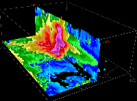
High-Res 3D Mosaic Project
As part of NMQ, NSSL has implemented a system that produces a national (CONUS) 3D radar mosaic grid with a 1-km horizontal resolution over 31 vertical levels and a 5-minute update cycle. The 3D reflectivity grid can be used for multi-sensor severe storm algorithms, regional rainfall products generation, aviation weather applications, and data assimilations for convective scale numerical weather modeling. More...
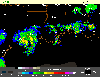
Next Generation Multisensor QPE (Q2)
Q2 continues NSSL's departure from radar-centric precipitation estimation and moves toward a multi-sensor approach focused on high-resolution integration of radar, satellite, model, and surface observations to produce very high-resolution precipitation estimates. More...

Q2 Verification System
QVS provides real-time and archived 3D Mosaic data and QPE products from a variety of sources, including Q2. A number of verification tools are available including product differences and performance statistics. Emphasis is placed on access to a variety of high-quality gauge networks (e.g., OK Mesonet, LCRA). More...