
The Library of Congress recently acquired six rare manuscript maps that were drawn by Michel Capitaine du Chesnoy, the skilled cartographer who served as the Marquis de Lafayette's aide-de-camp during the American Revolutionary War. Accompanying the largest map, which shows the Virginia Campaign, is a brief handwritten text summarizing the military maneuvers in that colony between April and October 1781.
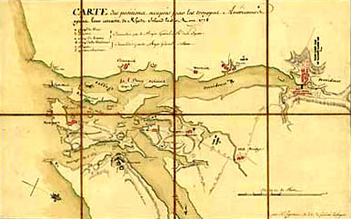
A portion of Capitaine's map of the Rhode Island Campaign.
The purchase of these maps was made possible by a generous gift from Mr. and Mrs. H.F. Lenfest, members of the Library's James Madison Council. Their funding of this acquisition is the Lenfests' contribution to the "Gifts to the Nation" program, which is part of the observance of the Library's Bicentennial. A major aspect of the program is to obtain private sector resources for collection development, including the purchase of historically significant items that the Library would otherwise not be able to purchase.
The Lenfest gift is the largest in the history of the Geography and Map Division. It has brought to the division's unsurpassed cartographic documentation of the American Revolution the rare items that record the role played by Lafayette in America's fight for independence. One of America's greatest heroes, Lafayette was mentioned by name on only two of the Library's almost 2,500 Revolutionary-era maps.
Idealistic, wealthy and just 19 years old when he arrived in America to join his hero George Washington in the fight for liberty, Lafayette was accompanied by his brilliant aide-de-camp and cartographer, Michel Capitaine du Chesnoy. Today Capitaine is recognized as one of the most skilled cartographers of the 18th century, because of the accuracy, insight and artistry that he brought to the science of cartography.
Each map in the group was drawn for a specific purpose. For example, the map of Ticonderoga and Saratoga (ca. 1777) in upstate New York contains new information about the location of the British army before and immediately after its stunning defeat at Saratoga, which resulted in bringing the French into the war. Lafayette's close ties to influential members of the French nobility were critical in gaining this desperately needed assistance.
While he was in France working to gain French support for the American cause, Lafayette showed samples of Capitaine's work in America, including two small, exquisitely drawn and colored maps of the Rhode Island Campaign, which are included in this group. Another map shows his ability as a military strategist near Germantown, Pa., where he camped by several possible escape routes to avert disaster at the hands of the much larger British forces. Even in retreat, Lafayette was brilliant, as is documented on this map (one of five known copies), the best known of Capitaine's manuscripts.
Lafayette's remarkable performance at Monmouth, N.J., greatly admired by Washington, won him a position in command of American troops in the Continental Army. The manuscript plan of the Battle of Monmouth, the last major engagement in the Northern Theater, shows the ravines and rugged terrain that were so influential in troop movements, as well as the outcome of this, the longest battle of the war.
Capitaine's large and detailed map of Virginia shows all of Lafayette's military skirmishes in Tidewater and Piedmont Virginia. It demonstrates Lafayette's skill in maneuvering, without engaging Cornwallis's army, up and down the peninsula between the James and York rivers while waiting for the arrival of the French troops under Rochambeau and the Americans led by Washington. Finally, when the rest of the forces were in place, Washington and Lafayette, aided by the French Expeditionary troops and the timely arrival of the French navy, backed Cornwallis into a position from which there was no escape. The final details leading to the American victory at Yorktown are recorded both on the map and in the journal.
The largest collection of Capitaine materials in any single repository, these historical treasures represent at least one-third of the known original maps drawn by Capitaine. They are the most exciting group of cartographic materials relating to the American Revolution to be available for purchase in more than a century. Drawn from the Americans' point of view, they add depth and new meaning to the other maps of that era already in the Library's collections.