Local weather forecast by
"City, St" or zip code |
Search by city or zip code. Press enter or select the go button to submit request |
|
To
NWS New Orleans/Baton Rouge Homepage
Top Weather Events of the 20th Century within the NWSFO New
Orleans/Baton Rouge Service Area
The National Weather Service Office in Slidell conducted a survey of its staff and past managers that were closely associated
and involved with the weather history of our area. A tally of the votes and comments by the panel of 17 meteorologists and
hydrologists made this a most interesting endeavor. Some of the events come as no surprise that they rate so high, as they
were the molders of some of our local history, good or bad. Some of our more notable weather episodes locally made the
national Top 10 list revealed by National Weather Service Headquarters before Christmas. The New Orleans/Baton Rouge
service area comprises of all parishes east of the Atchafalaya River, the Mississippi coastal counties of Hancock, Harrison
and Jackson, along with Pearl River, Walthall, Pike, Amite, and Wilkinson Counties.
What is considered a significant event? Some try to apply a formula of dollars lost, lives lost or harmed, or some other
measure. Perhaps the most important factor is the number of individual lives that are touched or affected from an event - a
loved one lost, an entire town destroyed, widespread ruin. In the case of approaching Hurricane Georges, an
unprecedentedly large portion of the population had to evacuate a vulnerable coastline, a memory that will linger on local
minds for quite some time. Several of the events were from generations past, but the stories still remind us of what can
happen in our area.
Throughout the 1900's, Southeast Louisiana and Southern Mississippi experienced a vast array of weather episodes. At the
close of this century, it helps to reflect on what has happened in the past, how much we have learned and improved upon,
and how to prepare for what can potentially happen in the future. Before revealing the list of top vote getters, many worthy
events were considered, none of which were least important for their impact on the local communities. Here are several of
those episodes for honorable mention, in chronological order.
September 27, 1906: Pascagoula, Mississippi Hurricane
A violent hurricane moved onshore near the Pascagoula River, producing a storm surge in excess of 10 feet from
Jackson County, MS to the westernmost Florida peninsula. A total of 134 lives were lost from Pascagoula to
Pensacola, FL during this hurricane.
September 24, 1956: Hurricane Flossy
This hurricane completely submerged Grand Isle with its
surge and beared down on the Greater New Orleans area. Local residents
remember evacuating to shelters with fear of the 1947 hurricane
on their minds.
- October 3, 1964: Hurricane Hilda
Hilda reached maximum strength about 350 miles south of New Orleans and headed into Southeast Louisiana. Winds
to 135 mph were recorded at Franklin, LA. Despite a massive evacuation effort, 38 fatalities were accounted. Most
notable was the killer tornado spawned at Larose, LA, claiming 22 of the 38 lives and injuring 200 others.
Spring 1973: Mississippi River Flood
A heavy snow thaw in the Ohio River and upper Mississippi River Valleys sent the Lower Mississippi River into
extensive flood. The City of New Orleans was threatened, thereby prompting the opening of the Bonnet Carre and
Morganza Spillways - a first.
April 1979 and 1983: Pearl River Floods
These two major floods inundated many towns and cities along the Pearl River for weeks at a time. In both instances,
portions of Interstate 10 over the Pearl River basin was covered by flood waters between Slidell and the Mississippi
State Line.
Summer/Fall 1985: Hurricane Season
An unforgettably active season which saw an erratic moving Hurricane Elena threaten the Mississippi Gulf Coast, turn
towards Florida, only to loop back and make landfall at Ocean Springs, MS. That season also saw a minimal
Hurricane Juan spin erratically across south Louisiana soaking the region with flooding rains and storm surge
inundation for several days. Many parishes in southeast Louisiana were declared federal disaster areas.
August 26, 1992: Hurricane Andrew
After striking lower Florida as a Category 4 hurricane, it moved into south Louisiana. While approaching Louisiana,
Andrew spawned a deadly tornado in Laplace, LA, killing 2 people and causing $1.5 million damage several hours
prior to Andrew's landfall.
December 31, 1996: Dense Fog pile-up
Dense sea fog over the coastal region provided hazardous driving conditions that resulted in a 100 vehicle chain
reaction pile-up on the I-10 twin spans over eastern Lake Pontchartrain. The pile-up claimed one life with 47 others
injured. The Interstate was closed down all day, impacting the arrival of Sugar Bowl attendees from Florida into the
Crescent City.
September 27, 1998: Hurricane Georges
Large scale evacuation of the City of New Orleans and the Mississippi Gulf coast as Georges approaches the mouth of
the Mississippi River, ultimately making landfall at Biloxi, MS. That evacuation effort was the largest effort in U.S.
history at the time, overwhelming the infrastructure of the region for several hundred miles. The Louisiana Superdome
was used as a last resort evacuation shelter for the first time.
Top Ten
In the interest of minimizing subjectivity the following listing is broken into what were considered events number 6 through
10 in chronological order and events 1 through 5 in chronological order.
September 19, 1947: Mississippi Gulf Coast and New Orleans Area Hurricane
This Category 4 hurricane in south Florida proceeded towards the Mississippi and Louisiana coast as a Category 3
hurricane, moving into Lake Borgne and over downtown New Orleans. Tides rose to 12 feet at Biloxi, Bay Saint
Louis and Gulfport, MS. A total of 51 lives were lost, 17 in Florida, 12 in Louisiana and 22 in Mississippi. Total
damage in 1990 dollars was more than $700 million. A storm surge of 16 feet occurred in the Slidell area of Lake
Pontchartrain while most of downtown New Orleans was flooded extensively due to tidal surges from Lake
Pontchartrain.
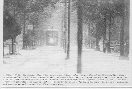
December 31, 1963: New Orleans Area Heavy Snow
A most unusual weather event for the otherwise balmy and mild climate of the Gulf Coast. A low pressure system that
developed in the southern Gulf of Mexico and moving towards the Florida peninsula interacted with intruding cold air
across the Deep South to produce heavy snow along the Gulf Coast. New Orleans Audubon Park measured four and a
half inches of snow while the Slidell area measured nine inches. This was the greatest snowfall to occur in the Greater
New Orleans area this century. Portions of the region became snowbound due to a lack of snow removal equipment.
May 3, 1978: New Orleans Flash Flood
A squall line approaches the Greater New Orleans area from the west, intersecting a stationary front that was settled
over the city. The result was a morning of torrential rains in excess of 10 inches, with rates of 2 inches per hour at
times. Coffins were lifted from ground level tombs, along with empty gasoline tanks at service stations in the New
Orleans area. The city's population was at a virtual standstill as nearly all main arteries were flooded or inaccessible
well into the evening hours.
 December 22-26, 1989: Arctic Outbreak December 22-26, 1989: Arctic Outbreak
The most significant cold spell of the century for the Deep South.
New Orleans experienced 64 consecutive hours at or below 32
degrees Fahrenheit and a total of 81 out of 82 hours below freezing.
A total of 15 hours were below 15 degrees with the lowest reading
of 11 degrees on the morning of the 23rd. A low temperature of 8
degrees was recorded at Baton Rouge. Snow and sleet paralyzed
transportation systems where as much as two to four inches of
snow accumulated in Lafourche and Terrebonne Parishes. Snow
and ice covered the ground in New Orleans. The greatest impact
was on breakage of water pipes in homes and businesses. Over 100
fires resulted in the New Orleans area within a 24 hour period due
to a loss of water pressure and improperly utilized heating sources. Ice formed over shallow lakes and waterways
where commercial fishing took heavy losses. Five weather related deaths occurred in the service area during this rare
Arctic outbreak.
May 8-9, 1995: Widespread Torrential Rainfall and Flood
A cold front approaching from the west stalled after moving east of the Baton Rouge area. An abundance of tropical
moisture over southeast Louisiana and coastal Mississippi was ignited by the approaching front with a nearly
continuous train of thunderstorms pounding over the same area from Morgan City, across the metropolitan New
Orleans area, and from Mandeville to upper Harrison County, MS on the night of the 8th. A large swath of 4 to 12
inches of rain fell that night with a maximum of 12.4 inches at the New Orleans International Airport. The entire area
affected experienced widespread flooding of homes and businesses and the metro area was halted to a standstill as the
Interstate system had portions inundated and nearly all major arteries were impassible. The second night saw similar
results, only displaced about 10 to 20 miles farther north as a new round of repeat thunderstorms developed over
northern Lake Pontchartrain, moving across the southern half of St. Tammany Parish and continuing across the lower
counties of Mississippi. A large area of 10 to 16 inches of rainfall extended from extreme eastern Tangipahoa Parish
all the way to the Mississippi-Alabama state line. Widespread flooding of streets and record flooding of many streams
and creeks occurred in the Lake Pontchartrain Drainage Basin as well as the Gulf Drainage. The second night saw a
maximum of 15.8 inches reported at the Abita Springs Fire Tower. The two day maximum was a bucket survey
measurement of 27.5 inches in extreme northeastern part of Hancock County, MS near Necaise. In Louisiana, a
maximum of 24.46 inches was measured at Abita Springs. In all, the event lasted for 40 hours and damaged 44,500
homes and businesses. Seven deaths were directly related to the flooding. Eleven parishes and counties were declared
federal disaster areas where $3.1 Billion in insurance claims were accounted. This was the costliest single non-tropical
weather related episode to affect the United States on record.
TOP FIVE
April 24, 1908: Amite, LA to Purvis, MS killer Tornado
Excerpt from "The Tornado Project" (credit to Thomas Grazulis) -- "This major tornadic event touched down near
"Weiss" in NW Livingston Parish, and moved ENE. Two people were killed at "Dennis Springs". In St. Helena Parish,
two were killed near Montpelier. The worst damage in Louisiana took place in Amite, Tangipahoa Parish, where the
path was said to have been over two miles wide. At least 29 people were killed in the town of Amite, and four others
died south of Wilmer. Eleven people were injured in the Aurora-Franklinton area of Washington Parish, and nine
people were killed near Pine. Crossing into Mississippi near Balltown, the tornado killed two people in Marion
County...continuing onward into Forest County 8 miles south of Hattiesburg." Fifty-five people were killed in the
town of Purvis as most of the town was leveled to the ground. In all 143 people were killed and 770 injured making
this the seventh deadliest tornado event in United States history.
September 29, 1915: Grand Isle Hurricane
This devastating Category 4 hurricane moved over Grand Isle and into the Greater New Orleans area. Winds were
measured at 140 mph at Grand Isle. 275 people were killed across Southeast Louisiana as the storm moved up the
Mississippi River. In Leeville, LA, only 1 building out of 100 survived the storm.
1927 Great Mississippi River Flood
Mississippi River floods have been recorded since DeSoto's expeditions of 1543. Man has tried to tame this major
artery of the United States ever since. Federal legislation was enacted on May 15, 1928, with the passage of the Flood
Control Act as a result of the Great 1927 Flood. An unusually wet period from August 1926 through the Spring of
1927 soaked the middle Mississippi Valley. A period of excessive rainfall during the first three weeks of April proved
to be a disastrous climax to the rainy period. In 19 hours on April 14-15, the New Orleans area received over 14
inches of rainfall, while much of Arkansas and southern Missouri received over 9 inches in a one week period. The
lower tributaries of the Mississippi River were experiencing record flooding along the Arkansas and Red Rivers,
contributing to high flood crest moving down the mainstem. Baton Rouge exceeded its flood stage of 35 feet on
February 12th and remained above flood stage until July 14th, a period of 153 days. The river at Baton Rouge crested
at 47.8 feet on May 15th, nearly 2 feet higher than its previous record set in 1922, and a record that still exist today.
On April 25th, the stage at New Orleans was at a record 21.0 feet. The main flood crest had not reached the city yet,
and fears were mounting that this major commerce hub of the era was in danger of being inundated. By order of the
Governor, the levee was dynamited at a point on the river 14 miles south of New Orleans, at Caernavon on April 29th.
The effort lowered the river level one-half foot before the crest passed New Orleans on May 15th at 20.7 feet. Then
entire levee system along the reach of the Mississippi River was decimated, and a large government effort was
employed to restore and construct new and better structures for flood control. These efforts helped launch Commerce
Secretary Herbert Hoover into the White House in the ensuing presidential election. The impact of this flood was 16.5
million acres of land in seven states inundated and 246 people died. Over 600,000 people were driven from their
homes and damages totaled $230 million in 1927 standards. The river was 80 miles wide in some places.
September 9, 1965: Hurricane Betsy
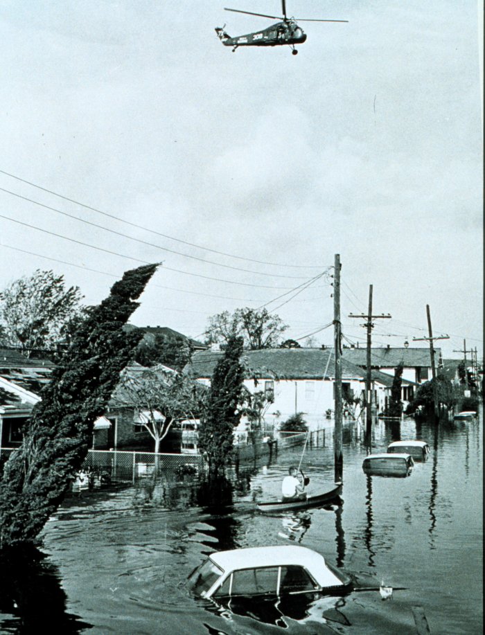 The New Orleans area was still recovering from the
affects of Hurricane Hilda of October 1964. Concerns
were growing about the city's vulnerability to a
hurricane moving just west of the Mississippi River
towards the Greater New Orleans area. During the
latter days of August 1965, a hurricane was moving
across the Atlantic Ocean and began to make a
seemingly harmless curve well of the Florida Atlantic
coast, which would ultimately see the storm go out to
sea. However, Betsy had different ideas and made a
complete loop some 350 miles east of St. Augustine,
Florida and was now heading south towards the Grand
Bahamas. On September 7th, Betsy began to move due
west and crossed extreme south Florida and the Florida
Keys as a Category 3 hurricane. Betsy then accelerated
to the northwest and moved into Barataria Bay on the
evening of the 9th. This placed New Orleans on the
worst side of the storm and sending the storm surge up
the Mississippi River and into Lake Pontchartrain. A
storm surge of 10 feet caused New Orleans to suffer its worst flooding since the hurricane of 1947 and proved
inadequacies in the levee protection system surrounding the area. The resulting levee improvements spared the city
from similar flooding in 1969 when Hurricane Camille impacted the area. Betsy claimed 81 lives and was the first
United States hurricane to produce over $1 billion damage, thus becoming known as Billion Dollar Betsy. The affects
of Betsy were also felt well inland after landfall. The potent hurricane moved up the Mississippi River into Baton
Rouge, where maximum winds were measured as East-Northeast at 58 mph with gusts to 92 mph. The New Orleans area was still recovering from the
affects of Hurricane Hilda of October 1964. Concerns
were growing about the city's vulnerability to a
hurricane moving just west of the Mississippi River
towards the Greater New Orleans area. During the
latter days of August 1965, a hurricane was moving
across the Atlantic Ocean and began to make a
seemingly harmless curve well of the Florida Atlantic
coast, which would ultimately see the storm go out to
sea. However, Betsy had different ideas and made a
complete loop some 350 miles east of St. Augustine,
Florida and was now heading south towards the Grand
Bahamas. On September 7th, Betsy began to move due
west and crossed extreme south Florida and the Florida
Keys as a Category 3 hurricane. Betsy then accelerated
to the northwest and moved into Barataria Bay on the
evening of the 9th. This placed New Orleans on the
worst side of the storm and sending the storm surge up
the Mississippi River and into Lake Pontchartrain. A
storm surge of 10 feet caused New Orleans to suffer its worst flooding since the hurricane of 1947 and proved
inadequacies in the levee protection system surrounding the area. The resulting levee improvements spared the city
from similar flooding in 1969 when Hurricane Camille impacted the area. Betsy claimed 81 lives and was the first
United States hurricane to produce over $1 billion damage, thus becoming known as Billion Dollar Betsy. The affects
of Betsy were also felt well inland after landfall. The potent hurricane moved up the Mississippi River into Baton
Rouge, where maximum winds were measured as East-Northeast at 58 mph with gusts to 92 mph.
August 17, 1969: Hurricane Camille
Only one of two Category 5 hurricanes to landfall on a United States coastline. Hurricane Camille evolved from an
Atlantic tropical wave near the Cape Verde Islands that traveled into the western Caribbean Sea before developing
into a tropical storm on August 14th. After crossing the extreme western tip of Cuba, she took aim on the Mississippi
River delta. On the morning of the 17th, Camille rapidly intensified into a Category 5 system and the entire Mississippi
and southeast Louisiana areas braced for her fury as warnings were extended to include the entire Mississippi Gulf
coast and the New Orleans area. Hurricane reconnaissance aircraft reported a central pressure of 901 millibars, or
26.63 inches of mercury, and winds estimated at 190 mph near its center. Harrison County Civil Defense Director,
Wade Guice, proceeded with a door-to-door evacuation effort in the Gulfport and Biloxi communities. Many adhered
his advice, others didn't. On the night of the 17th, Camille moved just east of the mouth of the Mississippi River then
continued towards the eastern side of Bay St. Louis, making landfall at Pass Christian, MS. Winds sustained over 200
mph at her peak but accurate measurements were not attainable due to failure of wind equipment from the extreme
winds. An unprecedented storm surge of 25 feet crashed into the Mississippi Coast, inundating everything within two
miles of the beach from Henderson Point to Biloxi. Party-goers at the Richelieu Apartments in Pass Christian met their
fate when this multiple story structure was leveled. Ocean-going ships were washed ashore and smaller vessels littered
the area well inland. Train trestles and bay bridges were washed out and large segments of U.S. Highway 90 were
removed from the fierce tides and erosion. Deaths in Mississippi accounted for 135 of the 258 total. Louisiana had 9
deaths. Over 73,000 families suffered losses in Mississippi and Louisiana. Damage estimates exceeded $1.4 billion
along the Mississippi and Louisiana Gulf Coast. After devastating the Gulf Coast, Camille continued into the
Appalachians where many deaths occurred to extensive rainfall and widespread flash flooding. After 30 years, many
natives and long-time residents remember vivid details of this major event of our United States and local history. Local
reminders still exist, such as empty slabs where homes once stood, the St. Timothy Episcopal Church bell tower in
Biloxi, and a beached tugboat named the 'Hurricane Camille' now serves as a souvenir shop along Highway 90.
Hurricane Camille was also selected as one of the top ten weather events of the century for the entire U.S.

|
|

 National Weather Service Forecast Office