
USGS Toxic Substances Hydrology Program, 2000
The U.S. Geological Survey (USGS) Toxic Substances Hydrology
(Toxics) Program provides unbiased scientific information on the behavior
of toxic substances in the Nation's hydrologic environments. Program contributions
improve contaminated-site management and remediation, and enable informed decisions
by industry, management and regulatory agencies, and the public.
The objectives of Program activities are to:
- Develop methods to measure contaminants and their
degradation products at levels low enough to characterize
environmental transport and fate;
- Quantify the physical, chemical, and biological processes that
affect contaminant migration, transformation, and degradation in the
environment;
- Understand the ultimate fate of contaminants in hydrologic systems
and the potential long-term implications for human and environmental health;
- Describe the effects of contaminants on organisms,
ecosystems, and the food chain; and
- Develop simulation models to assess potential exposure to
contaminants and to design waste-disposal facilities, monitoring networks, and
remediation strategies.
Investigations of representative types of environmental contamination are
being conducted across the Nation and focus on:
Point-source subsurface contamination, and
Watershed- and regional-scale contamination.
The Toxics Program coordinates with federal land-management, regulatory, and
science agencies to ensure that current and future science needs are being met.
The Program complements the water-quality monitoring and assessment programs
of the USGS, states, and others by identifying new issues and emerging contaminants,
and by developing the knowledge and methods needed to meet future monitoring
needs. Scientists from universities, other federal agencies, and industry actively
participate in the Program's activities.
Investigations of Point-Source Subsurface Contamination
Point-source subsurface investigations are conducted at sites representative
of common contamination problems and geohydrologic settings. These investigations
are long-term, field-based studies conducted by interdisciplinary research teams.
Comprehensive physical, chemical, and microbial characterizations of the sites
establish field-laboratory conditions that provide fundamental knowledge of
the processes that control specific types of contamination problems. This fundamental
process knowledge is generalized to a wide range of field conditions by specific
field and laboratory experiments at other sites with varied conditions and properties.
The resulting knowledge and methods improve the effectiveness of and reduce
the cost of characterization and remediation at contaminated sites across the
Nation.
A unifying theme of these investigations is characterization of the natural
response of hydrologic systems to contamination. This makes them ideally suited
for assessing potential long-term impacts, evaluating the potential and limitations
of remediation by natural attenuation, and designing remediation-performance
monitoring.

Point-source subsurface investigations include:
- Ground-Water Flow and Transport in Fractured Rock - Mirror Lake, New
Hampshire. Research develops methods for defining the movement of water
and contaminants in fractured-rock aquifers. Contaminant transport and fate
is fundamentally different in fractured rock than in unconsolidated (sand
and gravel) aquifers. In many cases, remedial action is delayed or stymied
by the complexity of these problems.
- Landfill Leachate - Norman Municipal Landfill, Norman, Oklahoma.
Leachate from thousands of active and closed landfills across the Nation may
pose a threat to ground water and its receiving waters. This research is defining
the biogeochemical controls on the migration and fate of the complex mixture
of chemicals found in landfill leachate.
- Subsurface Contamination by Chlorinated Solvents - Picatinny Arsenal,
New Jersey. Knowledge gained from this research of the physical, chemical,
and biological processes that affect transport and fate of contaminants has
improved options for effective remediation of chlorinated solvents in the
subsurface. Studies at the Picatinny Arsenal and at other sites have defined
a range of natural microbial processes that transform chlorinated solvents
to less toxic chemicals.
- Waste Disposal and Contaminant Migration in the Arid Southwest - Amargosa
Desert, Nevada. The movement of moisture and radioactive and organic contaminants
in the thick zone between the land surface and the water table is being studied.
Such sites have been selected for waste disposal in arid areas. Research is
improving knowledge of the potential and the mechanisms for contaminant migration
in these environments.

Vertical shaft (5 feet in diameter and 45 feet deep) installed at the Amargosa
Desert Research Site provides access to measure movement of moisture and contaminants
in the dry zone above the water table.
- Crude Oil Contamination in the Shallow Subsurface - Bemidji, Minnesota.
Knowledge gained at this site of the processes that control migration and
fate of hydrocarbons in the subsurface has facilitated adoption of natural
bioremediation as a widely accepted remediation alternative for hydrocarbon
contamination.
- Subsurface Gasoline Spills may be the most frequently cited cause
of ground-water contamination.
- Conventional Gasoline - Galloway Township, New Jersey. Models
and field methods have been developed to quantify natural attenuation
of contaminants by biodegradation and volatilization, and to enhance natural
attenuation using vapor extraction.
- Oxygenated Gasoline - Laurel Bay, South Carolina. Use of Methyl
tert-butyl ether (MTBE) as a fuel oxygenate challenges the natural attenuation
paradigm for remediation of gasoline spills. MTBE is resistant to degradation
and moves readily in ground water. Research has documented how MTBE persists
in the subsurface and is focusing on the limits of natural attenuation
and alternative remedial strategies.
- Sewage-Contaminated Ground Water- Massachusetts Military Reservation,
Cape Cod, Massachusetts. A plume of sewage-tainted ground water downgradient
of a sewage disposal site is being studied. Measurements of very small-scale
variations in contaminant concentrations and results of field tracer experiments
are being used to improve models of how complex mixtures of contaminants move
and attenuate naturally in the subsurface.
An array of vertical multi-point sampling devices installed to
monitor small-scale subsurface geochemical heterogeneities in a contaminant plume at the Cape Cod, Massachusetts, research site. Knowledge and models developed at this site are employed at many sites with sparse data.
Investigations of Watershed- and Regional-Scale Contamination
Watershed- and regional-scale investigations address contamination problems typical of specific land uses or human activities that may pose a threat to environmental and human health throughout significant parts of the Nation. These studies involve characterizing contaminant sources and their mechanisms for affecting aquatic ecosystems, such as watersheds affected by abandoned mines. These studies involve widespread detection of compounds released to the environment through common use, such as use of agricultural chemicals. Contaminants and degradation products are measured at levels below existing water-quality standards to assess whether they are actually entering the environment and to define the mixtures in which they occur. The information provided by these studies is used for developing regulatory policies and standards, for registering the use of new chemicals, for decisions on what chemicals to manufacture, and for development of usage guidelines.
Investigations of watershed- and regional-scale contamination include:
- Contamination from Agricultural Chemicals - These investigations
address large-scale agricultural activities with similar crops and/or farming
practices. They focus on characterizing processes that affect dispersal of
chemicals in the atmosphere, ground water, and surface water; identifying
persistent degradation products; and developing methods to measure these compounds
in water samples at environmentally relevant concentrations. Results are used
by manufacturers, farmers, regulators, and the public. Two investigations
are under way.
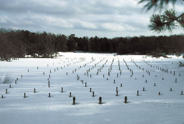
- The Midwest Corn Belt -This area extends across parts of 12 states
and accounts for about 65 percent of the total harvested cropland and
60 percent of herbicide use in the Nation. The project focuses on characterizing
the occurrence, transport, and fate of corn and soybean herbicides and
herbicide degradation products in streams, reservoirs, ground water, rainwater,
and air. Results of the study have influenced agricultural chemical-use
practices.

More than 800 samples from 303 wells in the twelve "corn belt"
states indicate that analyzing for herbicide degradates is essential for
accurate estimation of the total mass and frequency of detection of total
herbicide compounds.
- Cotton Agriculture Across the Southern U.S. - Pesticide usage
for cotton farming typically is three to five times that for corn or soybeans.
The areas of intense cotton growing under investigation - the Mississippi
Embayment, the High Plains of Texas, southern Arizona, and southern California
- have varied hydrologic settings and very different mechanisms for contaminant
migration in the environment.
- Human Influences on San Francisco Bay - Like all urban estuaries
in the world, San Francisco Bay receives toxic substances from a variety of
natural and human sources. Studies here focus on characterizing the interrelated
physical, chemical, and biological processes that affect contamination within
the Bay and the delta ecosystems. Results of these studies are providing an
understanding of the effects of contamination on species throughout the food
chain and of the effectiveness of resource-management strategies.

San Francisco Bay is affected by urban runoff, industrial and
municipal discharges, and agricultural runoff from nearby fertile river valleys.
(Landsat-7 image distributed by USGS EROS Data Center, Distributed Active Archive Center.)
- Contamination from Hard Rock Mining - Thousands of historical hard-rock
mines (such as gold, copper, and zinc mines) exist across the Western United
States. Mine dumps, tailing piles (the residue after ore processing), and
unmined mineral deposits often contaminate the surrounding watershed and ecosystems
when weathering of exposed minerals results in acid drainage and metals-enriched
waters. Research is focusing on the processes that affect migration of contamination
within the watershed and the resulting effects on the ecosystem. Studies are
under way in two areas with differing climate and hydrologic settings. The
results and methods developed at these sites are being used and demonstrated
through the USGS Abandoned Mine Lands Initiative.
- Historical Hard-Rock Mining in Rocky Mountain Terrain - Characterizing
mining contamination in mountain streams is often confounded by the facts
that numerous sources can take obscure pathways to the stream, and much
streamflow can occur within the coarse gravel streambed. Stream tracer
methods, which were developed and tested in the upper Arkansas River,
Colorado, have enabled identification of specific sources of stream
contamination.
- Historical Hard-Rock Mining in Southwest Alluvial Basins - In
this arid area, contaminants often are transported great distances by
ground water, and may threaten regional water supplies. At Pinal Creek,
Arizona, scientists are studying the geochemical evolution of a plume
of metals-laden ground water and its ultimate interaction with Pinal Creek.
The goal is to develop and test improved models of surface- and ground-water
interaction, and ground-water transport that are transferable to other
areas with different physical and chemical characteristics.

Silverton, Colorado, at the mouth of the upper Animas River and its
watershed in the background, where over 1,500 abandoned mine sites affect water and ecosystem quality.
- USGS Abandoned Mine Lands (AML) Initiative - The goal of this Initiative
is to develop a watershed- and science-based strategy for cost-efficient cleanup
of AML. The Initiative is under way in two pilot watersheds: the Upper
Animas River, Colorado, and the Boulder River, Montana. USGS is
working with federal land managers to clean up abandoned mines on or adjacent
to public lands. The watershed approach has enabled remedial actions to target
the most serious contamination sources.
- A National Assessment of Mercury in Aquatic Ecosystems - Recent dramatic
increases in fish-consumption advisories that now are issued in 40 states
demonstrate that mercury is a national concern. Aquatic ecosystems across
the Nation are being studied to identify the controls on accumulation of mercury
to toxic levels in the food chain. Ecosystems are being studied that are affected
by varied sources (mining, natural, and atmospheric sources) and have varying
potential to convert mercury to its most toxic form, methylmercury.
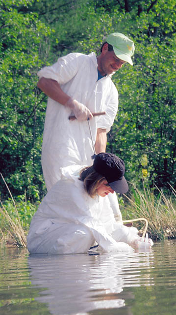
Clean sampling techniques enable measurement of mercury species at sub-nanogram
per liter concentrationsessential for understanding environmental cycling
and bioaccumulation in aquatic ecosystems.
- Amphibian Research and Monitoring Initiative - Program scientists
are providing information on hydrology, ambient water quality, and occurrence
of contaminants in support of this national multi-agency Initiative. Monitoring
is being conducted in seven regions. Information will be used to quantify
amphibian population declines and to identify potential causes.
- A National Reconnaissance of Emerging Contaminants - New compounds
continually enter the environment, either during intended use (such as pesticides
and fumigants) or via industrial, human, or animal wastes (such as detergents,
pharmaceuticals, antibiotics, and synthetic hormones). New low detection-level
methods are being developed, and a national survey of susceptible streams
and wells is under way. This effort will provide the first assessment of these
compounds in the Nation's waters.
- Herbert T. Buxton
|
For more information on the activities of the Toxic Substances Hydrology
Program, visit our web site at:
http://toxics.usgs.gov
Or write to:
USGS Toxics Program
MS 412
12201 Sunrise Valley Drive
Reston, VA 20192
|
The full citation for this fact sheet is:
Buxton, H.T., 2000, USGS Toxic Substances Hydrology Program, 2000: U.S. Geological
Survey Fact Sheet FS-062-00, 4 p.
This fact sheet is also available in pdf format
(1.1Mb file).
U.S. Department of the Interior
U.S. Geological Survey
USGS Fact Sheet FS-062-00
May 2000

|
|
|
