|
 |
 |
| Home | News | Organization |
|
|
Station List Observations Observations via Google Maps Recent Historical Obs Search Ship Obs Report NOAA Obs APEX DART® MMS ADCP TAO DODS HF Radar OSMC Dial-A-Buoy RSS Feeds Email Access Station Status NDBC Maintenance NDBC Platforms Partner Platforms Program Info About NDBC Met/Ocean Moored Buoy C-MAN TAO DART® VOS CSP IOOS® DAC Publications Hurricane Data Plots Mariners Weather Log Observing Handbook No. 1 Science Education FAQ Contact Us Links |
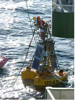
Notice: NDBC plans to conduct testing of its DART (tsunameter) network the week of January 12-16, 2009. Click here for details. Station 62091 - M2 - 20 NM East of Lambay
|
||||||||||||||||||||||||||||||||||||||||||||||||||||||||||||||||||||||||||||||||||||||||||||||||||||||||||||||||||||||||||||||||||||||||||||||||||||||||||||||||||||||||||||||||||||||||||||||||||||||||||||||||||||||||||||||||||||||||||||||||||||||||||||||||||||||||||||||||||||||||||||||||||||||||||||||||||||||||||||||||||||||||||||||||||||||||||||||||||||||||||||||||||||||||||||||||||||||||||||||||||||||||||||||||||||||||||||||||||||||||||||||||||||||||||||||||||||||||||||||||||||||||||||||||||||||||||||||||||||||
Owned by the Irish Department of Transport and maintained by the Marine Institute in cooperation with Met Eireann and the UK Met Office. |
Data from this station are not quality controlled by NDBC
|
Click on the graph icon in the table below to see a time series plot of the last 24 hours of that observation. | ||
 | Wind Direction (WDIR): | SSW ( 200 deg true ) |
| Wind Speed (WSPD): | 15.0 kts |
| Wave Height (WVHT): | 6.6 ft |
| Average Period (APD): | 6 sec |
| Atmospheric Pressure (PRES): | 29.55 in |
| Pressure Tendency (PTDY): | +0.00 in ( Steady ) |
| Air Temperature (ATMP): | 49.5 °F |
| Water Temperature (WTMP): | 49.1 °F |
| Dew Point (DEWP): | 47.3 °F |
| Wind Chill (CHILL): | 43.5 °F |
| Combined plot of Wind Speed, Gust, and Air Pressure | |
Data from this station are not quality controlled by NDBC
|
| | | | | | | | | | | | | | | ||||
| MM | DD | TIME (GMT) | WDIR | WSPD kts |
GST kts |
WVHT ft |
DPD sec |
APD sec |
MWD | PRES in |
PTDY in |
ATMP °F |
WTMP °F |
DEWP °F |
SAL psu |
VIS mi |
TIDE ft | |
|---|---|---|---|---|---|---|---|---|---|---|---|---|---|---|---|---|---|---|
| 01 | 16 | 1900 | S | 18.1 | - | 5.9 | - | 6 | - | 29.55 | +0.00 | 49.5 | 49.1 | 46.8 | - | - | - | |
| 01 | 16 | 1800 | SSW | 22.0 | - | 6.6 | - | 6 | - | 29.55 | +0.02 | 49.3 | 49.1 | 46.9 | - | - | - | |
| 01 | 16 | 1700 | SSW | 22.0 | - | 6.6 | - | 6 | - | 29.55 | -0.02 | 49.5 | 49.3 | 47.3 | - | - | - | |
| 01 | 16 | 1600 | SSW | 25.1 | - | 7.9 | - | 6 | - | 29.54 | -0.04 | 49.3 | 49.3 | 47.1 | - | - | - | |
| 01 | 16 | 1500 | SSW | 24.1 | - | 9.2 | - | 5 | - | 29.57 | -0.04 | 48.6 | 49.3 | 45.9 | - | - | - | |
| 01 | 16 | 1400 | SSW | 29.9 | - | 8.9 | - | 5 | - | 29.57 | -0.07 | 48.7 | 49.1 | 45.1 | - | - | - | |
| 01 | 16 | 1300 | SSW | 31.1 | - | 7.9 | - | 5 | - | 29.58 | -0.09 | 47.7 | 49.1 | 43.0 | - | - | - | |
| 01 | 16 | 1200 | S | 31.1 | - | 7.9 | - | 5 | - | 29.61 | -0.06 | 48.4 | 49.1 | 43.2 | - | - | - | |
| 01 | 16 | 1100 | S | 27.0 | - | 6.9 | - | 5 | - | 29.64 | -0.03 | 49.5 | 49.1 | 43.5 | - | - | - | |
| 01 | 16 | 1000 | SSW | 26.0 | - | 6.6 | - | 5 | - | 29.67 | -0.01 | 49.1 | 48.9 | 41.2 | - | - | - | |
| 01 | 16 | 0900 | SSW | 19.0 | - | 5.6 | - | 5 | - | 29.68 | +0.01 | 48.9 | 48.9 | 43.0 | - | - | - | |
| 01 | 16 | 0800 | SSW | 19.0 | - | 4.9 | - | 5 | - | 29.68 | +0.01 | 48.6 | 49.1 | 42.1 | - | - | - | |
| 01 | 16 | 0700 | SSW | 15.9 | - | 4.3 | - | 6 | - | 29.68 | +0.01 | 47.8 | 49.1 | 42.1 | - | - | - | |
| 01 | 16 | 0600 | SSW | 17.1 | - | 4.3 | - | 6 | - | 29.67 | +0.01 | 48.0 | 49.3 | 44.6 | - | - | - | |
| 01 | 16 | 0500 | S | 15.0 | - | 4.3 | - | 6 | - | 29.67 | +0.01 | 48.2 | 49.1 | 44.4 | - | - | - | |
| 01 | 16 | 0400 | SW | 14.0 | - | 4.9 | - | 5 | - | 29.67 | +0.01 | 48.6 | 49.3 | 44.6 | - | - | - | |
| 01 | 16 | 0300 | SW | 14.0 | - | 6.2 | - | 6 | - | 29.66 | -0.01 | 48.7 | 49.3 | 45.3 | - | - | - | |
| 01 | 16 | 0200 | SSW | 17.1 | - | 7.2 | - | 6 | - | 29.65 | -0.01 | 48.7 | 49.1 | 46.4 | - | - | - | |
| 01 | 16 | 0100 | SSW | 14.0 | - | 6.9 | - | 5 | - | 29.66 | +0.00 | 48.6 | 49.1 | 45.3 | - | - | - | |
| 01 | 16 | 0000 | SW | 12.0 | - | 7.2 | - | 5 | - | 29.67 | +0.01 | 47.3 | 49.3 | 44.4 | - | - | - | |
| 01 | 15 | 2300 | SSW | 22.0 | - | 7.5 | - | 5 | - | 29.66 | +0.02 | 50.0 | 49.3 | 47.3 | - | - | - | |
| 01 | 15 | 2200 | S | 19.0 | - | 7.2 | - | 5 | - | 29.66 | +0.03 | 50.0 | 49.3 | 46.9 | - | - | - | |
| 01 | 15 | 2100 | S | 20.0 | - | 6.6 | - | 5 | - | 29.66 | +0.05 | 50.0 | 49.3 | 47.1 | - | - | - |
| U.S. Dept. of Commerce National Oceanic and Atmospheric Administration National Weather Service National Data Buoy Center 1007 Balch Blvd. Stennis Space Center, MS 39529 Feedback Page last modified: January 15, 2009 |
Disclaimer Credits Glossary |
Privacy Policy About Us Career Opportunities |